| |  |  | | Lake Pontchartrain Atlas: | | | | | | | | | | | | | | | | | | | | | | | | | | | | | | | Environmental Issues |  | | | | | | | | | | | | | |  | | | | | | | | | | |  | Environmental Issues - Bonnet Carré Diversion: March 17 - April 18, 1997 Contributors: Haralampides, McCorquodale The USACE occasionally diverts Mississippi River water into Lake Pontchartrain through the Bonnet Carré Spillway. This action is taken when there is a threat of flooding of New Orleans due to high Mississippi River water levels. The Mississippi typically has much higher nutrient concentrations than Lake Pontchartrain; when these nutrients are discharged into the Lake they can act like a fertilizer, stimulating the growth of algae. Algal blooms have occurred during the summers following some of the Spillway openings and can create adverse conditions for fish in the Lake, as well as a potential human health danger due to toxins. A computer model which predicts the flow patterns and mixing characteristics was applied to the Lake Pontchartrain system to investigate the movement of fresh water entering from the Bonnet Carré Spillway during the 1997 opening (Figure 55). The fresh water moved eastward along the south shore and gradually expanded northward, eventually affecting the entire Lake after four weeks of diversion. The model showed that Lake Borgne started to experience Mississippi River water eight days after the opening of the Spillway. The model included seasonally accurate water inputs from all major rivers and waterways. The average Bonnet Carré input was 167,000 cfs. The maximum flow with all flood gates open was 250,000 cfs. 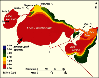 | | Figure 55: Simulated movement of Mississippi River Plume through the Lake Pontchartrain System: Bonnet Carré Spillway opening of 1997. | The Pearl River is a large river that follows the border between Mississippi and Louisiana on its journey south. The River branches before reaching the Lake, with some of the flow entering Lake Borgne and some entering into the Rigolets Pass. North of the Lake, the Pearl River runs through farmland. As it flows south, the water becomes polluted from the contaminants associated with agricultural runoff, as well as bacteria from dairy farming activities. The Pearl River can affect Lake Pontchartrain in two major ways: as a source of contaminants that are detrimental to the biota and recreational uses of the Lake and as an input of fresh water to the eastern region of the system. The Pearl River discharge may displace Gulf of Mexico waters, thus preventing high salinity waters from entering Lake Pontchartrain. 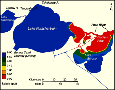 | | Figure 56: Pearl River impact on the Lake Pontchartrain System. | Figure 56 illustrates the output of a computer model which predicts the extent of the Pearl River water into the Pontchartrain system when the flow is equally distributed between the two branches of the river. Wind and river flow conditions observed during the period April 1-15, 1998 were simulated with a tracer used within the Pearl River. The red contour illustrates that the Pearl River water can impact a large portion of Lakes Borgne and St. Catherine, as well as the eastern portion of Lake Pontchartrain. It is important to estimate the movement of this water in order to better predict the impact of the Pearl River on the water quality, salinity patterns and biota of the Lake Pontchartrain system. « Previous | Next » |
