| |  |  | | Lake Pontchartrain Atlas: | | | | | | | | | | | | | | | | | | | Restoration |  | | | | | | | | | | | | | | | | | | | | | | | | | |  | | | | | | | | | | |  | Restoration - Restoration of the Lake Pontchartrain Basin Contributors: Penland, Maygarden, Lake Pontchartrain Basin Foundation 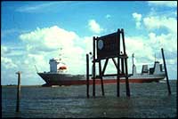 | | Figure 11: Mississippi River Gulf Outlet at Shell Beach. | Saltwater intrusion from the MRGO impacts the Lake and its surrounding wetlands. By causing stratification of the water column, the salty water entering at the IHNC can lead to severe hypoxia, which in turn can create a "dead zone" covering up to 259 km2 (100 mi2). This impacts the benthic organisms and fish populations. The saline water can also reach far into the western portion of Lake Pontchartrain and into Lake Maurepas, where it has a devastating effect on freshwater habitats. LPBF has long fought to address the impacts of the MRGO. It has had recent success by helping to establish a task force with the EPA which is developing plans to phase out the MRGO (Figure 11). « Previous | Next » |
