| |  |  | | Lake Pontchartrain Atlas: | | | | | | | | | | | | | | | | | | | Restoration |  | | | | | | | | | | | | | | | | | | | | | | | | | |  | | | | | | | | | | |  | Restoration - Restoration of the Lake Pontchartrain Basin Contributors: Penland, Maygarden, Lake Pontchartrain Basin Foundation Urban runoff is the largest single pollution source in the Lake Pontchartrain watershed. When it rains, storm water picks up pollution from streets, parking lots and lawns and transports it through the stormwater drainage system. On the south shore, stormwater containing a mixture of oil and grease, sediment and lawn-care chemicals drains into the Lake via drainage canals. On the north shore, as the towns rapidly grow, the impact of urban runoff is increasing. The area of paved land is expanding with the population, so both the volume and rate of polluted rainwater draining into the Lake is increasing on the north shore. 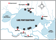 | 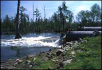 | | Figure 2: LPBF weekly water quality monitoring sites and parameters. Click on the image for a larger version with legend. | Figure 3: Gore pumping station, St. Bernard Parish. | To reduce urban runoff, LPBF has: - Established an extensive program to monitor Lake Pontchartrain's water quality (Figure 2).
- Initiated a project using wetlands to filter pollutants from stormwater and treated wastewater in St. Bernard Parish (Figure 3).
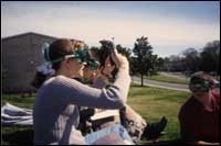
- Coordinated the Water Watch program for junior high and high school students (Figure 4).
- Installed instrumentation to provide continuous water quality monitoring on the Orleans Parish shoreline. These data are used to help further calibrate water quality predictive models which are hoped to eventually lead to a daily swim or no swim decision.
- Coordinated field trips to pumping stations, plus trash pick-ups and storm drain stenciling.
- Assisted Jefferson Parish in re-routing stormwater discharges away from the Lake (Figure 5).
 | 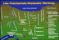 | | Figure 4: Water watch program participants. | Figure 5: Jefferson Parish stormwater system. Click on the image for a larger version. | « Previous | Next » |
