| |  |  | | Lake Pontchartrain Atlas: | | | | | | | | | | | | | | | | | | | Restoration |  | | | | | | | | | | | | | | | | | | | | | | | | | |  | | | | | | | | | | |  | Restoration - Restoration of the Lake Pontchartrain Basin Contributors: Penland, Maygarden, Lake Pontchartrain Basin Foundation 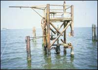 | | Figure 8: Abandoned oil and gas structures have been removed from lake. | 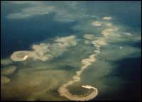 | | Figure 9: Shell dredging was banned in Lake Pontchartrain in 1990. |  | | Figure 10: SAV planting project monitored by UNO researchers and volunteers. | Between 1932 and 1990, the Lake Pontchartrain Basin has lost more than 188,356 acres of wetlands due to a combination of factors including dredging, filling, channelization, storm damage, flood control, natural subsidence and shoreline erosion. Currently, poorly planned development is causing significant loss of and damage to wetlands on the north shore of Lake Pontchartrain. During the 50 years prior to 1990, 75% of the Lake's productive SAV died due to alteration of the shoreline, especially on the south shore, as well as increased turbidity and poor water quality resulting from shell dredging and other sources of pollution. In order to protect habitats in the Basin, the LPBF have been working with others to: - Prevent damage to over 1,000 acres of aquatic and terrestrial habitat by coordinating efforts of five companies proposing new cross-Basin pipelines to combine operations into a single pipeline.
- Assist countless citizens to participate in federal state wetland permitting programs.
- Coordinate the removal of more than 20 abandoned oil and gas structures from the Lake (Figure 8).
- Organized efforts to end shell dredging in the Lake (Figure 9), resulting in a ban in 1990.
- Coordinate ongoing replanting and monitoring of SAV (Figure 10).
« Previous | Next » |
