|
|
Click on the thumbnail images to view Dahlia Shoals perspective images at full size, or use the Location Map at the bottom of the page to navigate to perspective views of other locations.
Figure 7.1- Shaded relief map of Dahlia shoal and southwest side of Ile
aux Galets. The outline of the image is marked by numerous smooth amphitheater-like
features opening to the southwest and northwest. Their original origin
is unknown but at present they appear to be in filling with sediment.
The Dahlia shoal portion of the area southwest of the 500 m wide linear
trough has rough relief, an arcuate ridge, and radiating ridges to the
northest similar to those seen at Gull Island Reef. This area is underlain
by carbonates of the Detroit River Group (Mich. DNR). (See
full-size JPEG--451 kb)
Thumbnails
 |
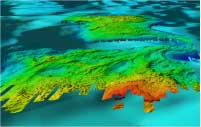
Figure 7.2 - Oblique view looking southeast over Ile
Aux Gallet with Dahlia Shoal in background. The rougher relief (of
cobbles and boulders or outcrop?) occurs in water depths less than
12-15m. Limestone outcrops are reported from Ile Aux Gallet underwater
observations (Somers, 1968). In deeper water patches and re-entrants
of smoother morphology indicate depositional sites (sand?). Distance
across the bottom of image is about 2.1 km. (JPEG
293 kb) |
 |
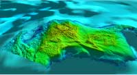
Figure 7.3- Oblique Perspective of Dahlia Shoal looking
west . Two lobe like troughs at the left and shallow portion of the
reef terminate eastward in rough relief and meter-high ridges similar
to Boulder and Gull Island Reefs (Fig. 2 and 3). Sediment sand drapes
the deeper slopes to the south and east, but less so to the west and
south suggesting sediment transport from those directions. Distance
across the bottom of perspective is about 3.9 km. (JPEG 244 kb) |
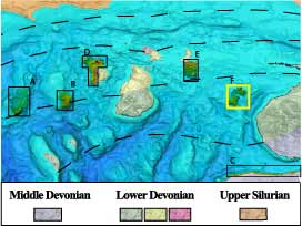
Location Map
Click on the boxes within the Location Map below to view the mapview and perspective images of those locations.

|