USGS - science for a changing world

Open-File Report 03-120

Bathymetry and selected perspective views of 6 reef and coastal areas in Northern Lake Michigan.

Little Traverse Bay
 

Home
Intro
Map Views
  Boulder Reef
  Gull Island Reef
  Little Traverse Bay
  Trout and High Island Reefs
  Hog Island Reef
  Dahlia Shoals
Data
  XYZ
  Grid
Posters

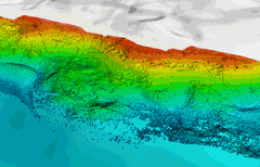
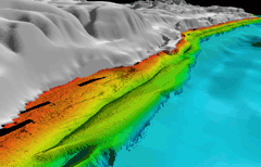
Click on the thumbnail images to view Little Traverse Bay perspective images at full size, or use the Location Map at the bottom of the page to navigate to perspective views of other locations.

Little Traverse Bay Map with Arrows

Figure 4.1 - Shaded relief map of nearshore area along the south coast of Little Traverse Bay. Onshore the surface morphology of this region is marked by glacial drumlins aligned northwest-southeast overlying the Devonian carbonate strata, of the Traverse Group (Fig.1). Nearshore and at the western end of the survey the morphology is irregular and block suggesting possible outcrops of consolidated units of glacial or Devonian strata. Further offshore a series of smooth, shore parallel (east-west) an echelon ridges 1-3m high dominate to the 25-30 m depth of the survey, especially east of Nine Mile Point. This suggests more fine grained materials in the nearshore as you progress east toward the head of the bay. (See full-size JPEG--399 kb)

Thumbnails

Oblique looking SW at Big Rock Point Figure 4.2 - Oblique view looking southwest at nearshore off Big Rock Point. Rough irregular morphology (bedrock outcrop?) draped with shore normal bedforms extends from the coast offshore to the edge of the survey, except in the far left foreground, which appears depositional. Distance across the bottom of image is about 2.1km. (JPEG 266 kb)
Oblique of eastern portion of Little Traverse Bay Figure 4.3 - Oblique view of the eastern portion of the Little Traverse Bay data set looking west along the coast. This view illustrates the rough relief of outcrops (?) and coarser (?) substrate material nearshore (reds and orange depths and the the shore parallel offshore bar (green) in depths of 10-15m over lain by bar-normal bedforms (and shore normal) in the left foreground. Distance across the bottom of image is about 2.2 km.(Black Strips in Lidar data are gaps.) (JPEG 96 kb)

Location Map
Click on the boxes within the Location Map below to view the mapview and perspective images of those locations.

location map with link to detailed reefs Link to Trout and High Island shoals Link to Gull Island Reef link to Hog Island Shoals Link to Dahlia Shoals Link to Little Traverse Bay Link to Boulder Reef


Accessibility FOIA Privacy Policies and Notices

Take Pride in America logo USA.gov logo U.S. Department of the Interior | U.S. Geological Survey
URL: http://pubsdata.usgs.gov/pubs/of/2003/0120/gl-LittleTraverse.html
Page Contact Information: GS Pubs Web Contact
Page Last Modified: Wednesday, 02-Apr-2014 15:38:59 EDT