USGS - science for a changing world

Open-File Report 03-120

Bathymetry and selected perspective views of 6 reef and coastal areas in Northern Lake Michigan.

Trout and High Island Reefs
 

Home
Intro
Map Views
  Boulder Reef
  Gull Island Reef
  Little Traverse Bay
  Trout and High Island Reefs
  Hog Island Reef
  Dahlia Shoals
Data
  XYZ
  Grid
Posters

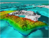
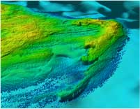
Click on the thumbnail images to view Trout and High Island Reefs perspective images at full size, or use the Location Map at the bottom of the page to navigate to perspective views of other locations.

Trout and High Island Reefs Map

Figure 5.1 - Shaded relief map of Trout Island Shoal (upper left), Trout Island area, and west coast of High Island. The rough nearshore relief west of High Island (bedding in the Devonian Bois Blanc Formation?) transitions abruptly offshore to a smooth depositional substrate (sand?). North of High Island the east-west linear trends similar to those seen on Boulder Reef underlie sediment drapes (sand?). The linear and box work texture is similar to that seen in Boulder and Gull Island reefs (Figures 2 and 3) The morphology of Trout Island Shoal suggests a large sand shoal migrating eastward over underlying units of the Devonian Bois Blanc Formation (Fig.1) or glacial deposits. Two or three gouges or grooves of unknown origin (ice?, man made?) extend east from the south end of the shoal for over 1 km. The slopes of the Shoal are relatively steep, especially on the the eastern edge. (See full-size JPEG--413 kb)

Thumbnails

Oblique looking NE along the west coast of High Island Figure 5.2 - Oblique perspective looking northeast along the west coast of High Island. The rough morphology nearshore (glacial or Bois Blanc Formation) is similar in texture and trend to Gull Island reef (Figure 3.1).This relief abruptly changes to a smooth (sand?) bottom along a 2-3m scarp at about 10 m water depth the bottom of this scarp may represent the location of a previous (glacial?) shoreline. This sharp transition and shoreline-like? feature is not obvious at other mapped sites. Distance across the foreground of this perspective is 5.0 km. (JPEG 242 kb)
Oblique looking SE at Trout Island Shoal Figure 5.3 - Oblique perspective looking southeast at Trout Island Shoal with 3 generations of recurved spits in the right foreground. Pronounced northwest-southeast linear ridges (glacial?) partly obscured by recent patches of smooth sand(?) occur east (left in this figure) of the shoal. Distance across the foreground of this perspective is 3.0 km. (JPEG 336 kb)

Location Map
Click on the boxes within the Location Map below to view the mapview and perspective images of those locations.

location map with link to detailed reefs Link to Trout and High Island shoals Link to Gull Island Reef link to Hog Island Shoals Link to Dahlia Shoals Link to Little Traverse Bay Link to Boulder Reef


Accessibility FOIA Privacy Policies and Notices

Take Pride in America logo USA.gov logo U.S. Department of the Interior | U.S. Geological Survey
URL: http://pubsdata.usgs.gov/pubs/of/2003/0120/gl-trout_high.html
Page Contact Information: GS Pubs Web Contact
Page Last Modified: Thursday, 03-Apr-2014 12:29:45 EDT