Open-File Report 03-120
|
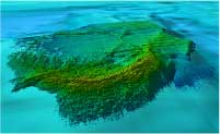
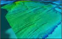
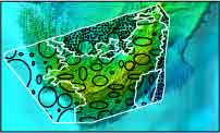
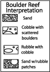
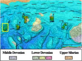
Click on the thumbnail images to view Boulder Reef perspective images at full size, or use the Location Map at the bottom of the page to navigate to perspective views of other locations. 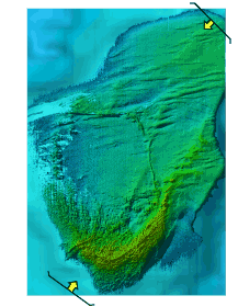 Figure 2.1 - Shaded relief map of Boulder Reef, N. Lake Michigan. The rough relief in the southern, and shallowest, portion of the reef is covered with gravel, cobbles and boulders (Fig 2.2, Edsall et al., 1989 and video data) with rare patches of sand. The coarse bottom material is roughly organized into a boxwork of highs and lows less than a meter high. The arcuate ridge at the south end of the reef is likely a remnant depositional glacial feature from a small lobe of ice moving from the north. The coarse texture material extends to beyond the depths of the survey to the west and south, but transitions to a sand substrate to the east and north. (Video observations by Greg Kennedy, personal communication) The strong east west lineations in depths of 15-20 m in the northern half of the image could be related to either glacial movement but this is transverse to movement suggested by the ridge to the south, or to older glacial events or to the extrapolated underlying Devonian, Bois Blanc Formation (Fig.1). These lineations are drapes overlain by sediment (sand with smooth) morphologies. Clean sand was sampled in this part of the ridge. Underwater observations of Somers (1968) reports, "till generally is covered with sand, gravel, cobbles or boulders" from a dive near the south end of this reef. Note: The faint N-S lineations seen in the central part of the image are artifacts of the data gathering flight lines. (See full-size JPEG--328 kb)
Location Map
|
|||||||||||||

![]() U.S. Department of the Interior |
U.S. Geological Survey
U.S. Department of the Interior |
U.S. Geological Survey
URL: http://pubsdata.usgs.gov/pubs/of/2003/0120/gl-boulder.html
Page Contact Information: GS Pubs Web Contact
Page Last Modified: Wednesday, 02-Apr-2014 15:00:24 EDT