High-resolution seismic-reflection surveys in the nearshore of outer Cape Cod, Massachusetts, USGS Open-File Report 03-235
|
Title Page Introduction Previous Work Geologic Setting DATA ACQUISITION AND PROCESSING Seismic-Reflection Interpretation Integration with Land-based Stratigraphy Conclusions Acknowledgements References Cited |
Data Acquisition and Processing
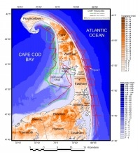
The R/V Rafael, operated by the USGS Woods Hole Field Center (WHFC), was used for data acquisition during two field operations. In the fall of 2000 the survey was conducted on the Cape Cod Bay side of the outer Cape (Fig. 2 and Fig. 4). During the summer of 2001, more data were acquired on the seaward side, east of the outer Cape, and additional lines were collected in Cape Cod Bay (Figs. 2 and 4). The vessel was navigated with a differential global positioning system (DGPS) that provided real-time horizontal positioning accuracy of 10 m or better. Navigational data, along with bathymetric soundings, were digitally logged with Hypack (Coastal Oceanographics, Inc.) hydrographic and navigation software. In addition, navigation from the DGPS was logged on the seismic acquisition computers.
Two single-channel subbottom-profiling systems were used mostly simultaneously during both phases of data acquisition. A dual frequency Knudsen 320BR 3.5 kHz Chirp and 200 kHz echosounder system was deployed using transducers on a side-mount pole. The Knudsen acquisition software recorded the data in standard SEG-Y (Barry and others, 1975) digital format. Shot-point navigation files recorded DGPS position in relation to shot point. The 3.5 kHz Chirp system recorded 67 ms two-way travel time (TWT) of reflection data. The second system, a Boomer seismic-profiling system, provided a higher energy source (100 joules) than the Chirp system. This provided deeper penetration of the subbottom than the Chirp system. However, with a peak frequency of about 1800 Hz, the vertical resolution is not as high as the Chirp. The Boomer data were also acquired in SEG-Y format using a Triton-Elics Delph seismic system. Shot-point navigation recorded DGPS location in the SEG-Y header. The Boomer fired at a rate of 0.5 s and recorded 250 ms TWT of data. All of the digital data acquired were copied to optical CD-R media in the field.
|