Title Page
Introduction
Previous Work
GEOLOGIC SETTING
Data Acquisition and processing
Seismic-Reflection
Interpretation
Integration with
Land-based Stratigraphy
Conclusions
Acknowledgements
References Cited
|
Geologic Setting
 |
| Figure 2. |
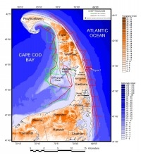
The bedrock geology beneath outer Cape Cod is not well known. It has been presumed to consist of Paleozoic and Precambrian igneous and metamorphic rocks similar to those exposed in southeastern Massachusetts (Hoskins and Knott, 1961; Oldale, 1969; Oldale and O'Hara, 1990). Two deep USGS boreholes (Gerhard and Phillips, 1989), one in North Eastham and the other located in Chatham (Fig. 2), reached granitic bedrock. A rift basin filled with sedimentary rocks of Triassic-Early Jurassic age trends east-west beneath the town of Truro (Ballard and Uchupi, 1975). Sedimentary coastal plain rock has been inferred to overlie bedrock in places beneath Cape Cod Bay (Hoskins and Knott, 1961; Oldale and O'Hara, 1990).
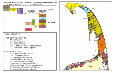 |
Figure 3.
|
Outer Cape Cod was formed between two major ice lobes during the Late Wisconsinan deglaciation. The Cape Cod Bay lobe occupied what is now Cape Cod Bay and was the source for the Harwich outwash plain deposit to the south (Fig. 3). With the retreat of the Cape Cod Bay lobe, a proglacial lake formed as is evidenced by the delta and glaciolacustrine deposits along the northern side of Cape Cod. A readvance of the Cape Cod Bay lobe formed a moraine where there is now a bathymetric high (Fig. 2) known as Billingsgate Shoal (Oldale and O'Hara, 1984).
The South Channel lobe bounded outer Cape Cod to the east and also occupied the Nauset Inlet area. Evidence for the position of the South Channel lobe in the Nauset inlet area is seen in seismic profiles interpreted by Aubrey and others (1982), where shore-parallel seismic lines east of Nauset Inlet show a distinct undulating reflector that pinches out at the sea floor to the north and south. Aubrey and others (1982) interpreted this surface to have formed at the base of the South Channel lobe. The South Channel lobe was a source of a series of outwash plain deposits that form outer Cape Cod (Fig. 3). The Nauset Heights, Wellfleet, Highland, and Truro outwash plain deposits are successively younger in relative age from south to north (Oldale, 1982; Oldale and Barlow, 1986; Uchupi and others, 1996). However, the Eastham outwash plain, deposited between the Nauset Heights and Wellfleet outwash plains, is believed to be the youngest outwash deposit derived from the South Channel lobe. The Eastham outwash plain was probably deposited while part of the South Channel lobe occupied the topographic low at Nauset Inlet.
Sea level was lower than it is at present during the Wisconsinan glaciation, and the Earth's crust was depressed by glacial loading. Sea level rose as the Cape Cod Bay and South Channel lobes retreated north. This marine incursion is evident from glaciomarine deposits in Stellwagen Basin and northern Cape Cod Bay (Oldale, 1988). In Cape Cod Bay there is a prominent seismic reflector between the glaciolacustrine and glaciomarine units. In the outer Cape Cod area, these units only underlie the Holocene Provincetown Hook, as the marine transgression did not reach the remaining outer Cape. Interfingered with the glaciomarine unit and deposited above glacial drift deposits in northern Cape Cod Bay is a predominantly seismically amorphous unit that thickens to south, indicating a southerly source (Oldale and O'Hara, 1990). West of Provincetown this unit contains concave to dipping internal reflectors that suggest a deltaic origin. Oldale (1988) suggests that the unit may have been deposited by a debris flow based on the amorphous seismic signature. An alternate interpretation from Birch (in Oldale and O'Hara, 1990) suggests that the amorphous unit is an ancestral progradational feature similar to the Holocene-age Provincetown Hook. This unit is restricted to the Provincetown area of outer Cape Cod.
Following glacial retreat and the marine incursion, isostatic rebound of the crust exceeded eustatic sea-level rise. As a result, outer Cape Cod and Cape Cod Bay remained above sea level as is marked by a regressive, erosional unconformity observed in seismic profiles in Cape Cod Bay (Oldale and O'Hara, 1990). Fluvial valleys cut into Pleistocene deposits indicate a northward drainage of Cape Cod Bay.
When eustatic sea-level rise exceeded isostatic rebound, relative sea level transgressed Pleistocene glacial deposits and the regressive fluvial deposits in Cape Cod Bay. Oldale and O'Hara's (1990) seismic profiles show a mostly planar reflector resulting from wave-cut erosion during the Holocene transgression. This unconformity underlies the Holocene progradational Provincetown Hook but pinches out where Holocene beaches overlie glacial deposits of the outer Cape Cod area.
The paper by Uchupi and others (1996) summarizes the work of others that have studied the coastal evolution of outer Cape Cod. It is important to note that the post-glacial eastern side of outer Cape Cod initially extended 4 to 2.5 km east of the present erosional bluffs. Therefore, a considerable amount of the stratigraphic section (~30 m) where our seismic profiles are located on the east side of outer Cape Cod has been eroded as a result of the Holocene transgression. A wave cut terrace forms the nearshore on the east side where this wedge of glacial sediment has been removed. The volume of sediment removed during bluff erosion and terrace formation during the last 6,000 years provided the sediment needed for the progradation of Provincetown Hook and the spits along southeastern outer Cape Cod (Zeigler and others, 1965; Uchupi, 1996). Similarly, a wave-cut terrace bounds the Truro shoreline on the Cape Cod Bay side.
|
