High-resolution seismic-reflection surveys in the nearshore of outer Cape Cod, Massachusetts, USGS Open-File Report 03-235
|
Title Page Introduction PREVIOUS WORK Geologic Setting Data Acquisition and processing Seismic-Reflection Interpretation Integration with Land-based Stratigraphy Conclusions Acknowledgements References Cited |
Previous Work
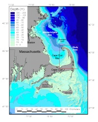
Earlier seismic-reflection surveys of Cape Cod Bay and east of Cape Cod began with Hoskins and Knott (1961) who collected high-resolution seismic profiles in Cape Cod Bay and defined a seismic stratigraphic framework of the region. Oldale and O'Hara (1990) established the relationship of the onshore regional geology of the Cape (Oldale, 1982) and the stratigraphy of the Gulf of Maine to the seismic stratigraphy of Cape Cod Bay. Uchupi and others (1996) have added interpretations of the stratigraphy and coastal evolution of outer Cape Cod. They based their interpretations on their own seismic profiles and those of Aubrey and others (1982) located east of Cape Cod as well as the Cape Cod Bay seismic data collected by Oldale and O'Hara (1990). More recently, water gun profiles were collected in the Stellwagen Bank area (Fig. 1) with profiles that extend to Cape Cod Bay and the Atlantic side of outer Cape Cod (USGS, R. Oldale and R. Rendigs, unpublished data). |