High-resolution seismic-reflection surveys in the nearshore of outer Cape Cod, Massachusetts, USGS Open-File Report 03-235
|
Title Page Introduction Previous Work Geologic Setting Data Acquisition and processing SEISMIC-REFLECTION INTERPRETATIONS Integration with Land-based Stratigraphy Conclusions Acknowledgements References Cited |
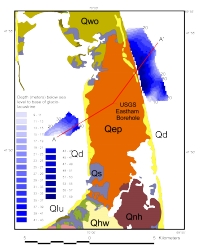
Seismic-Reflection InterpretationsOur interpretation of the seismic profile data utilizes the seismic stratigraphic names used by Oldale and O'Hara (1990). From oldest to youngest they are: bedrock of Paleozoic age (Pz); sedimentary Tertiary age coastal plain deposits (Tcp); undifferentiated glacial drift (Qd) and glaciolacustrine deposits (Qdl) of Pleistocene age; post-glacial fluvial channel fill (Qf) of late pleistocene and Holocene age; and marine deposits (Qm) of Holocene age. Unconformities occur between Pz, Tcp, and Qd. Unconformities, other than bedrock boundaries, include the glacial to post-glacial boundary, a regressive surface (ru), and the Holocene transgressive surface (tu). The Paleozoic bedrock (Pz) surface mapped in Cape Cod Bay by Oldale and O'Hara (1990) could not be mapped closer to shore with our data. The Boomer profiles in the nearshore did not have sufficient penetration to image this surface. Tertiary Coastal Plain (Tcp) was not resolved or is not present in the nearshore area east or west of outer Cape Cod.
A series of 15 in3 water gun seismic profiles (USGS, P. Valentine, unpublished data) that extend from Cape Cod Bay, north of Provincetown, and to the eastern side of the outer Cape were interpreted to map the bedrock surface (Fig. 4). A single water gun line extends along the eastern side of outer Cape Cod approximately 2-3 km from shore (Fig. 4). The bedrock surface rises from about 150 meters below sea level (mbsl) off Provincetown to about 100 mbsl off Chatham. A bedrock high east of Nauset Heights rises to 85 mbsl. A deposit of possible Tertiary coastal plain sediments(Tcp) were interpreted from the water gun profiles north of Provincetown but was not observed east of Cape Cod. There was no evidence of the Triassic rift valley (Ballard and Uchupi, 1975) in this seismic profile. Back to Top
Most of the profiles on both the east and west sides of outer Cape Cod are characterized by discontinuous and chaotic internal reflectors with occasional areas of layered reflectors. The layered reflectors appear to be deformed in some areas. This unit is inferred to represent part of the glacial drift unit (Qd) that Oldale and O'Hara (1990) mapped in Cape Cod Bay. More specifically, the layered portion of this unit is inferred to be stratified drift or glaciolacustine deposits (Qdl).
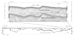
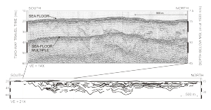
On the east side of outer Cape Cod, east of Nauset Inlet, there is a continuous undulating reflector above glacial drift in two areas, east of Pleasant Bay and east of Nauset Inlet, which pinches out at the sea floor to north and south (Fig. 5). This is the same reflector mapped by Aubrey and others (1982), which they inferred to be the basal surface of the South Channel lobe that formed these depositional lows. They infer that glacial drift lies below this reflector. Above this surface there are numerous cut-and-fill structures within the unit that fills these depressions. The unit above the undulating reflector was originally believed to originate from glaciofluvial outwash. However, it is possible that this unit which contains prograding internal reflectors is Holocene marine fill derived from the erosion of glacial deposits to the north (Aubrey and others, 1982; Uchupi and others, 1996). We do not observe the progradational fill in this unit on our seismic profiles, and the unit seems to be dominated by fluvial cut-and-fill structures. Back to Top
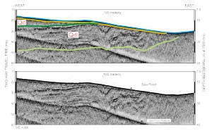
A few locations along the outer Cape Cod nearshore showed a significant seismic facies within the Qd unit. This facies is characterized by closely spaced (rhythmic) internal reflectors and is mapped on the Atlantic Ocean side of South Wellfleet and North Eastham (Fig. 6). These internal reflectors are clearly imaged in the Chirp profiles (Fig. 7). In other areas of the nearshore, Chirp profiles barely penetrated the subbottom, indicating a physically different facies. Poor subbottom penetration and discontinuous-to-chaotic reflectors may represent sand and gravel glacial drift deposits; good penetration and resolution of continuous internal reflectors suggest silt and clay glaciolacustrine deposits (Qdl).
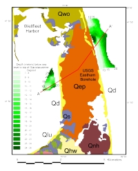
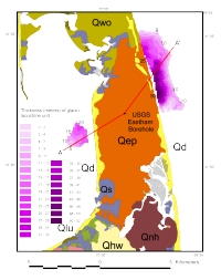
We mapped the depth to the upper surface of glaciolacustrine deposits (Qdl) located east of South Wellfleet and North Eastham (Fig. 8). In this location, the upper part of the unit has been eroded away by the Holocene transgression in parts of the nearshore (Fig. 7 and Fig. 8). The base of the unit (Fig. 9) is not as clearly defined as the upper surface, but the unit is at least 50 m thick (Fig. 10). The glaciolacustrine deposits (Qdl) dip to the southwest, on the Atlantic Ocean side to underlie subaerial glacial drift with no indication of a horizontal facies change (Fig. 7). A similar area of closely spaced reflectors is located close to shore on the Cape Cod Bay side of Eastham (Fig. 11). We mapped the altitude of this upper surface, which is at the same altitude as the surface on the Atlantic Ocean side (Fig. 8). Based on this, the similarities of the seismic facies, and their position beneath the Eastham plain deposit, we infer that they are of the same unit. In Cape Cod Bay, this unit lies above deformed but relatively continuous reflectors. These deeper reflectors are within the glacial drift (Qd), and are likely to be glaciolacustrine deposits that were overridden by readvancing ice that formed the Billingsgate Shoal Moraine. Therefore, the glaciolacustrine facies would have been deposited during or after the readvance. There is an abrupt vertical facies change along the north side of the unit (Fig. 11) that suggests it was deposited close to an ice front (Cape Cod Bay lobe). Alternatively, the glaciolacustrine unit may postdate the readvance of the Cape Cod Bay lobe and the South Channel lobe may have been the source of fine-grained glaciolacustrine deposits. The glaciolacustrine deposit is capped by sand and gravel outwash of the Eastham Plain that was derived from the South Channel lobe (Oldale, 1982). We have no evidence from the offshore seismic profiles that the glaciolacustrine facies extends beneath the Wellfleet outwash plain. The glaciolacustrine unit pinches out to the north along the eastern shore near the Eastham Plain and Wellfleet Plain contact onshore (Fig. 10). There is evidence from onshore boreholes that glaciolacustrine deposits are extensive beneath all of the outwash plains of outer Cape Cod (E. Uchupi, written communication, 2003). Back to Top
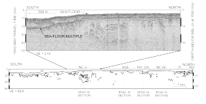
We observe an extensive reflector in the nearshore of Cape Cod Bay that appears to be an extensive erosional surface. This surface is the regressive unconformity (ru) interpreted by Oldale and O'Hara (1990). The surface is preserved as fluvial channels cut into glacial drift beneath Wellfleet Harbor and southeast Cape Cod Bay (Fig. 11). Paleochannels, which are not as well preserved, extend across the wave-cut-terrace in the nearshore area of Truro and Wellfleet of Cape Cod Bay. Most notable is a channel complex that extends west from the Pamet River Valley. East of outer Cape Cod, the regressive unconformity (ru) is not observed in the seismic profiles because much of the upper stratigraphic record east of our seismic profiles was removed by marine erosion during the Holocene transgression.
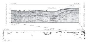
The Holocene transgressive unconformity is the surface (tu) mapped by Oldale and O'Hara (1990) in the deeper water of Cape Cod Bay. This surface is best observed as a flat and continuous reflector that is traced from the deeper water of Cape Cod Bay to the shallow nearshore terrace along the west side of Truro. This surface is at the base of the Holocene marine and progradational deposits comprising the Provincetown Hook (Fig. 12). The surface was traced close to shore near North Truro where it likely continues towards land and pinches out beneath the modern beach. Back to Top | ||||||||||||||||||||||