|

OFR 2004-1003 Home
Introduction
Geologic Setting
 Bathymetry
Data
Acquisition and Processing
Sidescan Imagery
GIS Data Catalog
References
Figures List
Acknowledgments
Contacts
Disclaimer
README
|
BATHYMETRY DISCUSSION
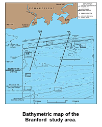
The sea floor in the central and southern parts of the Branford study
area has a relatively smooth gradient that slopes gradually toward the
south-southeast (DiGiacomo-Cohen and others, 1998). However, the sea
floor in the northern part of the study area is more complex.
 Two
isolated bathymetric highs, Townshend Ledge and Branford Reef, occur in
the northwestern and northeastern parts of the study area, respectively.
These bathymetric highs are composed of reworked glacial materials that
represent the offshore continuation of the Madison moraine (Flint and
Gebert, 1976; Needell and others, 1987). Water depths in the study area
range from less than 2 m on the crest of Branford Reef and less than 6 m
on the crest of Townshend Ledge to more than 26 m in the southeast
corner of the study area. Townshend Ledge rises about 10 m over the
surrounding sea floor which progressively shoals toward the
northwest. Branford Reef rises about 8 m above the adjacent sea floor,
but is flanked by shallow, isolated, east-west trending elongate
depressions on its northern and southern sides. Two
isolated bathymetric highs, Townshend Ledge and Branford Reef, occur in
the northwestern and northeastern parts of the study area, respectively.
These bathymetric highs are composed of reworked glacial materials that
represent the offshore continuation of the Madison moraine (Flint and
Gebert, 1976; Needell and others, 1987). Water depths in the study area
range from less than 2 m on the crest of Branford Reef and less than 6 m
on the crest of Townshend Ledge to more than 26 m in the southeast
corner of the study area. Townshend Ledge rises about 10 m over the
surrounding sea floor which progressively shoals toward the
northwest. Branford Reef rises about 8 m above the adjacent sea floor,
but is flanked by shallow, isolated, east-west trending elongate
depressions on its northern and southern sides.
The bathymetric data layer supplied with this report was originally
released by DiGiacomo-Cohen and others (1998). The contours, which
are from NOAA 1:100,000 bathy-topo
sheets and bathy-fishing maps, were digitally obtained partially by
table digitizing and through
scanning and vectorization.
|

