Home Page
Mosaic &
Explanation
GIS Data
Contacts
About this Disk
|
Methods
Click on the figure below to view larger
image.
The sidescan-sonar data were acquired using an AMS (Acoustic Marine
Systems, Inc.) 120-kHz sidescan-sonar system, owned and maintained
by the Woods Hole Oceanographic Institution's Deep Sea Submergence
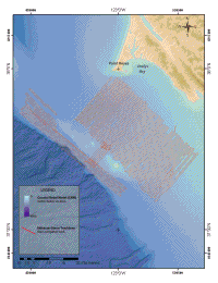
Laboratory durint USGS Cruise F9-89-NC aboard F/V Farnella. Initially, sidescan-sonar data (Figure
4) were collected at a swath width of 500m with 400m trackline
spacing, providing 20% overlap. After the collection of several
lines of sidescan-sonar data, trackline spacing was increased to
500m, and the remainder of the survey was conducted using a 750m
swath width (Karl and others, 1993).
Navigation for the cruise used three systems:
(1) Global Positioning System (GPS); (2) LORAN-C; and (3) shore-based,
line-of-sight transponder net (Del Norte system) (Karl
and others, 1993). For real time positioning, the primary
system was chosen either manually by the navigator or selected
automatically by computer (Karl and others,
1993). Tracklines (see Figure
4 ) were within 100m of preplotted tracks
when using GPS and LORAN-C and within a few meters when navigating
under the Del Norte system (Karl and others,
1993). See GIS data also.
The analog signal from the sidescan-sonar tow vehicle was acquired
with and stored on a QMIPS data acquisition system, manufactured
by Triton
Technologies, Inc. The data were then transferred from QMIPS
to a Masscomp supermicrocomputer for shipboard processing and data
archival (Karl and others, 1992).
The data were processed on board using a suite of software (XSonar
and ShowImage) to remove water column artifacts, correct slant-range
distance to true ground distance, and to apply a linear contrast
enhancement to maximize the dynamic range of the data (Danforth
and others, 1991). Individual sidescan-sonar track lines were
then mapped within a Universal Transverse Mercator (UTM) coordinate
system, printed with a Raytheon 850 thermal display unit, and pasted
to a mylar UTM grid in order to build a hard-copy mosaic while at
sea. The hard-copy mosaic was used as a base for further sampling
and ground-truth efforts.
In 2003, due to the enhancements in computing technologies and improvements
in sidescan-sonar processing software suite, the sidescan-sonar
data collected during the 1989 USGS cruise F9-89-NC
were revisited in order to create a digital sidescan-sonar mosaic
of the Gulf of Farallones sonar data. All raw data were copied from
the archival format of 8 mm tapes to a LINUX computing system. The
Xsonar and ShowImage software packages were used to process the
sonar data as follows: 1) a median filter (2 x 3 boxcar) was applied
to the raw data, effectively minimizing speckle and stripping noise
present in the data; 2) slant-range distance was converted to true
ground distance (using a flat seafloor assumption) and the water
column was removed; 3) navigation was edited and re-merged with
the sonar files; 4) across-track normalization was applied in order
to minimize across-track variation in the data primarily due to
distance from the source; and 5) finally, each sonar line was mapped
at a 4 meter/pixel resolution within a universal transverse mercator
(UTM) coordinate system and saved in raw format (Danforth
and others, 1991; Danforth, 1997).
The processed sidescan-sonar data were then imported into Geomatica
Software Solutions, PCI software in order to create the digital
sonar mosaic. The digital sonar mosaic was mapped at 4 meter/pixel
resolution in UTM coordinate system Zone 10N, WGS84 datum. The mosaicking
procedure was as follows: 1) ground control points, or common features
present in overlapping sonar lines, were chosen to ensure proper
geographic positioning of each sonar line; 2) a stencil, or cutline,
was drawn around individual sonar lines; 3) the outlined sonar line
was then pasted into a ‘master’ mosaic file. This procedure
was followed for each sonar line, to build a sidescan-sonar mosaic
of the study region (Paskevich, 1992).
After completion of the sidescan-sonar mosaic, the data were exported
from PCI in TIFF format with a corresponding ESRI world file in
order to correctly display the image within a Geographic Information
System (GIS). The image file was imported into Adobe Photoshop 6.0.
A linear contrast enhancement was then applied in order to maximize
the dynamic range of the sidescan-sonar mosaic.
To provide a background image for the sidescan-sonar mosaic, bathymetric
and topographic data were extracted from the National Geophysical
Data Center (NGDC) Coastal Relief Model (CRM), Central Pacific Coast,
Volume 7 in ESRI grid format. Using the ArcMap Spatial Analysis
extension, a hillshade was then created from the ESRI grid file
(Azimuth:30; Altitude:45; z-factor:1). After creating a desirable
color scheme, the ESRI grid file and hillshade were combined using
the ArcView extension grid-to-image converter tool, available on
the ESRI Website (www.esri.com),
to create a TIFF image file and world file. The sidescan-sonar mosaic
and coastal relief image were then imported into ESRI ArcGIS and
ArcView GIS software in order to produce a digital, spatially accurate
map of the Gulf of the Farallones sidescan-sonar data.
Interactive Visualization
Software (IVS) Fledermaus software package was used to display
the sidescan-sonar mosaic and coastal relief data within 3-D space.
DMagic, a support application to Fledermaus, was used as an interface
to prepare the ESRI coastal relief grid for three-dimensional visualization.
DMagic was used to create a Digital Terrain Model (DTM) with a desirable
color legend, a shaded imagery file and a georeferencing file from
the imported ESRI coastal relief grid. These files were then assembled
into a Fledermaus object file within DMagic, and imported into the
Fledermaus 3-D visualization program. The sidescan-sonar TIFF image
was imported into Fledermaus to view the sidescan-sonar mosaic along
with a three-dimensional coastal relief background. Using a Polhemus
Isotrack II Bat (3-D input device with six degrees of freedom) supplied
by IVS, a three-dimensional flight path was recorded within the
data space. The flight path was then imported into the IVS Movieclient
application in order to produce an MPEG movie file of the 3-D data.
|