The Gulf of the Farallones: Sidescan-Sonar Imagery, USGS Open-File Report 2004-1082 |
|||||||||
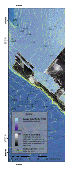
The map above (Figure 5) displays the sidescan-sonar mosaic generated from the data collected in the Gulf of the Farallones in 1989. Dark tones within the mosaic represent low-backscatter of acoustic energy, whereas lighter tones represent high-backscatter of acoustic energy. In general, backscatter energy decreases with diminishing sediment size, therefore darker regions of the mosaic represent areas of finer textures, whereas lighter regions depict areas of coarse sediment texture or outcrop. The sidescan-sonar mosaic shows a variety of intricate patterns and backscatter strength on the continental shelf. Generally, these patterns tend to follow the bathymetric contours of the sea floor (Karl and others, 1993) and are closely tied to the underlying geological structure of the region (Chin and others, 1997). According to Chin and others (1997), beneath the surficial sediments lies a basal unconformity composed of Tertiary and older units that forms a bedrock platform, seen within subbottom profiles as an angular unconformity in the northern region, and a disconformity within the central and southern regions.
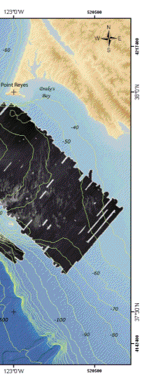
As described by Karl and others (1991), one of the most distinct areas covers the region to the north and east of the Farallon Islands and is composed of a digitate pattern of broad, shallow depressions floored by medium to coarse sand and gravel. These depressions have been interpreted by Karl and others (1991) as erosional features reflecting the regional flow patterns. The northward striking, finger-like extensions (Figures 5a and 5b) are seen as concave up topographic depressions in 3.5 kHz seismic reflection profiles (Chin and others 1997), and can be up to 8 km in length and as narrow as 250 m. According to Karl and others (1991), the linear depressions are floored by 1 m sand waves striking N-NE, which were resolved in earlier reconnaissance surveys using a 100 kHz Klein sidescan-sonar system. Many of the linear depressions are incised to the basal unconformity and upper surface of the underlying bedrock (Chin and others, 1997). Boundaries of depressions tend to become less pronounced in the south region of the mosaic (Figure 5b) where they are covered with a veneer of finer sediment (Karl and others, 1991). Another distinct, high-backscatter feature is found to the north of the Farallon Islands (Figure 5c). Sediment sampling interpretations made by Maher and others (1991) show this area to consist of fine, medium and coarse sands (Figure 2). Like the digitate bedform patterns, this feature generally follows the shape of bathymetric contours. The noticeably curved shape may portray the cross-section of an underlying fold exposed by erosion, alluding to tectonic deformational of the area. Chin and others (1997) indicate that structural folding visible in the mosaic coincides with exposed bedrock seen in 3.5 kHz seismic profile data. High-backscatter features located west of the Farallon Islands near the continental slope margin are also visible within the sidescan-sonar. These areas appear very coarse in texture, and may indicate outcropping units (Figure 5d, 5e, and 5f). Digitate patterns similar to those seen further east on the continental shelf are present (Figure5d) and are possibly erosional features derived from sediment transport by bottom currents. Home Page / Mosaic & Explanation / GIS Data / Contacts / About this Disk [an error occurred while processing this directive] |