Skip past header information USGS Logo with link to USGS Web page
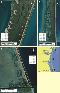
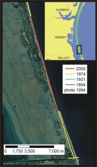
Coastal Vulnerability Assessment of Padre Island National Seashore to
Sea-Level Rise, USGS Open-File Report 2004-1090.

Map of Coastal Vulnerability

Skip past contents informationTable of Contents link to Title Page Link to Abstract Page Link to Introduction Page Link to Data Ranking Page Link to Padre Island National Seashore Page Link to Methology Page Link to Geologic Variables Page Link to Physical Process Variables Page Link to Calculating the Vulnerability Index Page Link to Results Page Link to Discussion Page Link to Conclusions Page Link to References Page

Geologic Variables

Figure 3.  Northern Padre Island National Seashore (very high vulnerability).
Figure 3. Northern Padre Island National Seashore (very high vulnerability). Click on figure for larger image.

The geomorphology variable expresses the relative erodibility of different landform types (Table 1). These data were derived from 1-meter resolution digital orthophotos of Padre Island (Table 2). In addition, field visits were made within the park to ground-truth the geomorphologic classification. Another useful guidebook produced by the Bureau of Economic Geology was used for geomorphologic classification and background information (Weise and White, 1980). The geomorphology of Padre Island was classified such that the northern and southern portions of the seashore are very high vulnerability, and the central portion of Padre was classified as high vulnerability. The northern part of Padre has relatively stable continuous dunes but they are lower in height than the dunes in central Padre ( Figure 3 A-C and Figure 4 A-C). The southern portion of Padre Island consist of discontinous dune ridges with numerous washovers (Figure 5 A-C).

Figure 4.  Central Padre Island National Seashore (high vulnerability).
Figure 4. Central Padre Island National Seashore (high vulnerability). Click on figure for larger image.
Shoreline erosion and accretion rates for Padre Island were calculated from existing shoreline data provided by the USGS National Assessment of Coastal Change project (Table 2). Shoreline rates of change (m/yr) were calculated at 200 m intervals (transects) along the coast using Digital Shoreline Analysis System (DSAS) software (http://woodshole.er.usgs.gov/project-pages/dsas/) to derive the rate of shoreline change over time. The rates for each transect within a 1-minute grid cell were averaged to determine the shoreline change value used here, with positive numbers indication accretion and
Figure 5.  Southern Padre Island National Seashore (very high vulnerability).
Figure 5. Southern Padre Island National Seashore (very high vulnerability). Click on figure for larger image.
negative numbers indicating erosion. Shoreline change rates on Padre Island range from 2 m/yr of accretion (low vulnerability) to greater than 2 m/yr of erosion (very high vulnerability) (Figure 6 A-C). A 14 km gap in shoreline data existed within southern Kenedy County (Figure 7). We chose to extrapolate a rate, which was in agreement with data from another shoreline change estimate for this area (Morton and Pieper, 1977).

The determination of regional coastal slope identifies the relative vulnerability of inundation and the potential rapidity of shoreline retreat because low-sloping coastal regions should retreat faster than steeper regions (Pilkey and Davis, 1987). The regional slope of the coastal zone was calculated from a grid of topographic and bathymetric elevations extending landward and seaward of the shoreline. Elevation data were obtained from the National Geophysical Data Center (NGDC) as gridded topographic and bathymetric elevations at 0.1 meter vertical resolution for 3 arc-second (~90 m) grid cells. Regional coastal slopes for Padre fall within the very high vulnerability category (< 0.3 % slope).

Figure 6. Historic Shoreline positions.
Figure 6. Historic Shoreline positions. Click on figure for larger image.
Figure 7. Location of the 14 km segment of shoreline in Kenedy County.
Figure 7. Location of the 14 km segment of shoreline in Kenedy County. Click on figure for larger image.

Back to Top


Skip Footer Information [an error occurred while processing this directive]