USGS Open-File Report 2004-1400
|
Home Introduction Cruise Data GIS Data Catalog 3D Visualization Acknowledgments Contacts Disclaimer Readme |
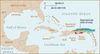
Geologic SettingThe Puerto Rico Trench (Figure 2), located north of Puerto Rico and the Virgin Islands, is the deepest part of the Atlantic Ocean. It is also associated with the
In February-March 2003, we conducted a seventeen day multibeam
bathymetry survey of the Puerto Rico Trench as part of a three
survey effort to provide a complete bathymetric coverage of
the Puerto Rico Trench and its vicinity. The 800-km long trench
was mapped from north of the Dominican Republic in the west
to NE of Anguila in the east at water depths between 2500 meters
and 8400 meters. Field work was funded by the National Oceanic
and Atmospheric Administration (NOAA) Office of Ocean Exploration.
It was carried out aboard the NOAA ship Ron Brown and utilized
the onboard SeaBeam 2112 multibeam bathymetry system. The unprecedented
detail of the bathymetry data and the accompanied back scatter
image resulted in significant scientific discoveries, gave us
insights into the forces that shape this plate boundary, and
provided important information for assessments of the earthquake
and tsunami hazards from the Puerto Rico Trench. A summary
of the scientific results is described in ten Brink, U.S., Danforth,
W., Polloni, C., Andrews, B., Llanes Estrada, P., Smith, S.,
Parker, E., Uozumi, T., New seafloor map of the Puerto Rico
trench helps assess earthquake and tsunami hazards in the northwest
Caribbean, EOS, v., 85, no., 37, p. 349, 354, 2004. For
additional information about the Coastal and Marine Geology
Program Caribbean studies, see the project
Web page. |