|
Despite the Clean Water Act of 1972 that mandated secondary treatment of sewage, the State of Massachusetts continued for nearly the next two decades to discharge metropolitan Boston's sewage sludge, primary-treated effluent, and raw sewage combined with stormwater during storms, directly into Boston Harbor. By the early 1980s, bottom-dwelling animal communities had disappeared from many locations in the harbor, beaches were frequently closed and the harbor was a national shame. In 1985 the Massachusetts Water Resources Authority was federal-court-ordered to meet the Clean Water Act requirements, and began a more than $4.0 billion cleanup project that included elimination of sludge discharge, secondary sewage treatment, and control of combined sewer overflows. One aspect of the project, however, created substantial controversy -- the relocation of the sewage outfall from the mouth of Boston Harbor to a site 15 km offshore in Massachusetts Bay. There was concern that the new outfall might turn Massachusetts Bay into the next Boston Harbor adversely affecting whales and other marine species in the region, which includes the Stellwagen Bank National Marine Sanctuary.
A broad theme of the U.S. Geological Survey (USGS) Coastal and Marine Geology Program is to improve understanding of geologic factors that influence the long-term quality and preservation of environments in their natural state. Toward this goal, the USGS has been a key player in the development of an integrated system of wave, circulation and sediment transport models that can be used to study the movement of polluted material in coastal waters. These models, when properly configured and validated with observational data, are often the best tools for evaluating management scenarios in the coastal ocean. One of the first steps in the development of such a model was implementation of a three-dimensional circulation model in Massachusetts Bay, a prototypical region of interest. Although developed to support sediment transport studies in the Bay, the timing was perfect to help Boston address a major environmental issue-the cleanup of Boston Harbor.
The model used for the effluent dilution simulations was a modified version of the Estuarine and Coastal Ocean Model (ECOM) originally developed by George Mellor and Alan Blumberg at Princeton University (Blumberg and Mellor, 1987). The model simulates currents and water properties in three dimensions (and time), driven by wind, river runoff, offshore discharges of freshwater, surface heating and cooling, tides, and sea-level fluctuations in the open ocean. In Massachusetts Bay, the model was used to study the flushing characteristics of Boston Harbor, to provide input for a bay wide water-quality model, and to assess the impact of possible chlorination failure at the new outfall location, as well as to predict effluent dilution.
The ECOM model was configured to encompass all of Massachusetts and Cape Cod Bays, with a resolution that varied from approximately 1 km in western Massachusetts Bay to about 6 km in the open ocean outside Massachusetts Bay. Simulations were performed over 3 year period from 1990 to 1992, including an 18-month period from January 1990 to July 1991 of particularly intense oceanographic data collection by the EPA-funded Massachusetts Bays Estuary Program (Geyer and others, 1992).
Comparing model results to measured oceanographic data showed that the model reproduced the development of seasonal stratification in the bay and the statistics for currents responsible for effluent transport in western Massachusetts Bay (Blumberg and others, 1993; Signell and others, 1996). The model was therefore judged to be appropriate for use in simulating effluent fields produced by continuous discharge in this region. Comparative dilution simulations for the existing outfalls and for the new outfall (Figures 5.1 and 5.2) projected that effluent concentrations in Boston Harbor would be greatly reduced by using the new outfall site, without significantly increasing concentrations in most of Massachusetts Bay (Signell and others, 2000). Thus, the model simulations supported relocation of the outfall from Boston Harbor to the site 15 km offshore.
These effluent dilution simulations were used to defend the construction of the outfall tunnel during a law suit claiming that the new outfall would endanger right whales in the Stellwagen Bank National Marine Sanctuary. The suit was unsuccessful, and construction of the outfall pipe was completed. The model results also helped MWRA evaluate and gain approval for downsizing of the planned secondary sewage treatment plant. It is estimated that the downsizing saved Boston area ratepayers about $160 million. In addition, the animated displays of model results have been used frequently as educational and outreach tools in public forums.
By utilizing data collected as part of the Massachusetts Bay monitoring program (1992-2004), it has been possible to use the measured concentration of ammonium (NH4+) in seawater as a proxy for the dilution of effluent that was predicted by the computer model. This approach was first used by Mickelson and others (2002) who showed that NH4+ was an effective tracer of sewage effluent over time scales of several days.
The measured effluent concentration of NH4+ at the treatment facility and concentration in the field were divided into pre and post-discharge groups (using the outfall startup date, Sept. 6, 2000) and averaged by season. Maps of effluent were created by dividing the average field concentrations by the average concentration discharged in the effluent (Figures 5.3, 5.4). These ammonium concentration maps mimic the numerical simulations. There is good agreement between model results (Figures 5.1 and 5.2) and field measurements (Figures 5.3 and 5.4).
Because of the complexity of driving forces and topography in Boston Harbor and Massachusetts Bay, computer models have played, and continue to play a critical role in managing these coastal waters. The ECOM model used for the effluent dilution simulations was also used as the basis for a full water quality model of the region (Hydroqual and Normandeau, 1995) and it continues to be used for regulatory purposes by the University of Massachusetts in collaboration with the MWRA (e.g. Jiang and Zhou, 2004). The ECOM model has since been replaced in the sediment transport modeling system used by the USGS with an even more capable three-dimensional model, the results of which are described in Section 6.
|
Click on figures below for larger images (PDF format).
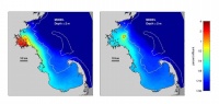 | Figure 5.1.
|
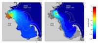 | Figure 5.2.
|
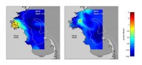 | Figure 5.3.
|
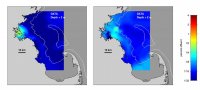 | Figure 5.4. |
|