Open-File Report 2005-1293
|
Appendix 1 - Geographic Information SystemA1.1. Data Access The spatial data on this DVD are delivered in two different forms:
All spatial data in vector form are stored inside a personal geodatabase based on the ArcMarine data model. Refer to section A1.2 below for more details on how to access the geodatabase and information on the ArcMarine data model. Viewing the data:
If you have ArcGIS 9.0 or higher: If you do not have any GIS software: If you have ArcView 3.x: Web Pages: | ||||||||||||||||||||||||||||||||||||||||||||||||||||||||||||||||||||||||
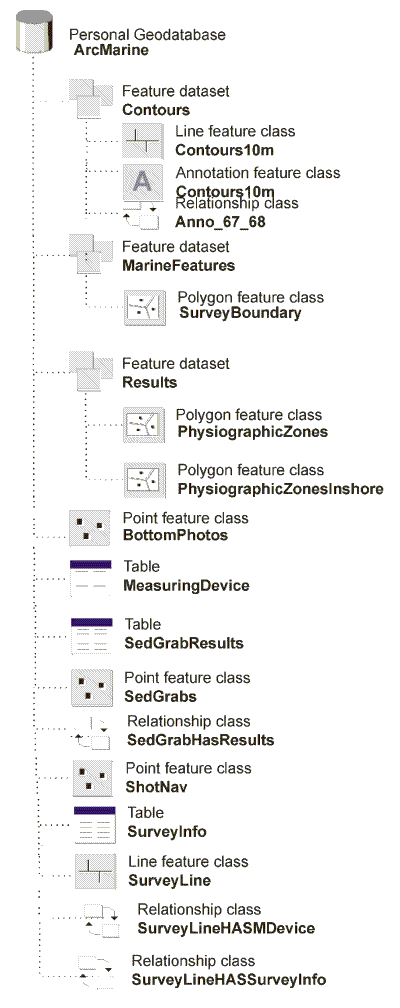
A1.2 Data stored inside the Personal Geodatabase. The data for this project are delivered here in a ArcGIS personal Geodatabase based on the schema of the ArcMarine Data Model. The project personal Geodatabase is accessible through ArcCatalog. A brief description of each feature class, feature dataset, and table is below. The schema of the Geodatabase is based on early drafts of the ArcMarine Data Model that is currently under development by ESRI and other collaborators. The ArcMarine Data Model is designed to provide a basic common data structure, or Geodatabase template, for most types of marine data with in the ArcGIS framework. To learn more about the structure of the data model refer to the ArcMarine Workgroup Web site (http://dusk2.geo.orst.edu/djl/arcgis/) or the ESRI Data Model Web site (http://support.esri.com/index.cfm?fa=downloads.dataModels.filteredGateway&dmid=21 The ArcGIS Marine Data Model represents a new approach to spatial modeling via improved integration of many important features of the ocean realm, both natural and manmade. The goal is to provide more accurate representations of location and spatial extent, along with a means for conducting more complex spatial analyses of marine and coastal data by capturing the behavior of real-world objects in a geodatabase. The model also considers how marine and coastal data might be more effectively integrated in 3-D space and time. Although currently limited to 2.5-D, the model includes "placeholders" meant to represent the fluidity of ocean data and processes 
Note: Figure as modified from the original provided by Michael Zeiler, ERSI. A1.3 Data stored outside the Personal Geodatabase.
This folder contains...
| |||||||||||||||||||||||||||||||||||||||||||||||||||||||||||||||||||||||||
 Back to Acknowledgments
  To Top of Page
  Forward to Next Section