Skip past header information
USGS - science for a changing world
CZM logo with link to CZM home page

U.S. Geological Survey Open-File Report 2007-1373

High-Resolution Geologic Mapping of the Inner Continental Shelf: Cape Ann to Salisbury Beach, Massachusetts


Skip past contents informationTitle Page / Table of Contents / List of Figures / Introduction / Maps / Data Collection/Processing / Interpretation / Summary / Acknowledgments / References Cited / Appendix 1 / Appendix 2 / Appendix 3 / Appendix 4 / Appendix 5
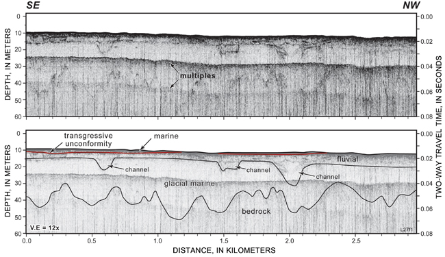

Figure 4.10. Seismic-reflection profile showing three small channels cut into glacial-marine sediment in the central part of the study area. The transgressive unconformity (red line) is eroded into the upper surface of fluvial deposits and locally overlain by a sheet of sandy marine sediment generally less than 1 m thick. See Figure 4.3 for location. A constant seismic velocity of 1500 m/s through water, sediment, and rock was used to convert from two-way travel time to depth.


Figure 4.10.  Seismic-reflection profile showing three small channels cut into glacial-marine sediment in the central part of the study area.  The transgressive unconformity (red line) is eroded into the upper surface of fluvial deposits and locally overlain by a sheet of sandy marine sediment generally less than 1 m thick.  See Figure 4.3 for location.  A constant seismic velocity of 1500 m/s through water, sediment, and rock was used to convert from two-way travel time to depth. 

Download the full size image in PDF format (4.7 MB).


Adobe Reader To view files in PDF format, download a free copy of Adobe Reader.


Skip USGS links group

Accessibility FOIA Privacy Policies and Notices

Take Pride in America logo USAGov logo U.S. Department of the Interior | U.S. Geological Survey
End of USGS links group