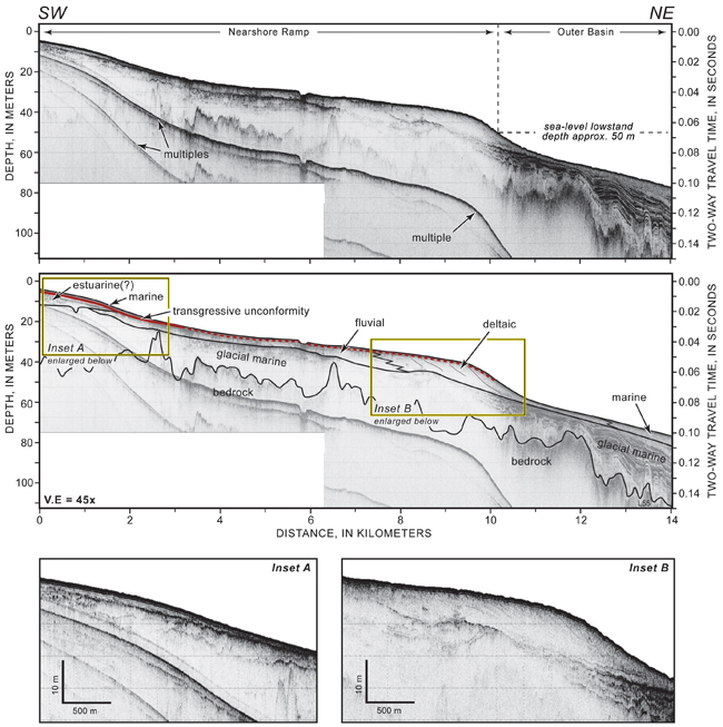
Figure 4.3. Seismic-reflection profile across the inner continental shelf. Stratified glacial-marine sediment rests on bedrock and is overlain by fluvial and deltaic deposits that formed during coastal regression and sea-level lowstand. Seaward-dipping clinoforms (inset B) indicate progradation of the delta offshore into a deep, muddy basin. The prominent transgressive unconformity (red line) is an erosional surface that caps the fluvial/deltaic sequence and grades to conformity below depths of about 50 m. A seaward-thinning wedge of sediment, interpreted as estuarine in origin, underlies shallow parts of the inner shelf (inset A). Holocene deposits of sandy marine sediment locally overlie the transgressive unconformity. See Figure 4.1 for location. A constant seismic velocity of 1500 m/s through water, sediment, and rock was used to convert from two-way travel time to depth.
Download the full size image in PDF format (5.4 MB).
 To view files in PDF format, download a free copy of Adobe Reader. To view files in PDF format, download a free copy of Adobe Reader.
|
 Title Page / Table of Contents / List of Figures / Introduction / Maps / Data Collection/Processing / Interpretation / Summary / Acknowledgments / References Cited / Appendix 1 / Appendix 2 / Appendix 3 / Appendix 4 / Appendix 5