U.S. Geological Survey Open-File Report 2008-1351
USGS Cold-Water Coral Geographic Database—Gulf of Mexico and Western North Atlantic Ocean, Version 1.0
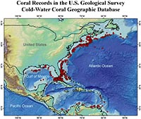
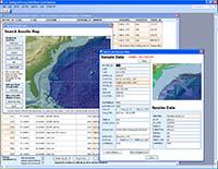
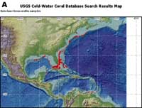
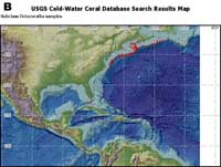
The USGS CoWCoG database, like other databases, can never be complete as long as exploration continues because new data will become available. Also, many publications refer to cold-water coral specimens, but do not give exact locations; some of these data could be included in future versions of the database after obtaining more accurate positional data. As the global importance of cold-water corals becomes clearer, discoveries of new cold-water coral areas are increasing, and new reports are being published. New versions of the CoWCoG database will be planned for release after a substantial number of additions or software updates have been made. A quick analysis of the data included in this database (figure 2) shows many areas where corals are apparently absent These areas may represent an absence of exploration by coral scientists, rather than a true absence of corals. One example of this is the distributions of hexacoral and octocoral data. Hexacorals appear to be distributed throughout the study area (figure 9A), whereas octocorals appear to be abundant in the area off the northeastern United States and absent in the Gulf of Mexico (figure 9B). This pattern results largely because one major source of data for the CoWCoG database was Dr. Les Watling’s deep-water coral database (Watling and others, 2003) which covers the areas off the northeastern U.S. and consists primarily of octocorals (his taxonomic specialty). The pattern in this case is probably a reflection of a particular scientist working in a particular region, rather than a reflection of the true distribution of octocorals. This also highlights a shortcoming of many biological expeditions: the shortage of coral taxonomists to identify specimens or examine video and photographic data. This dataset also includes only entries for which a particular suite of variables was available, primarily taxonomic data at least down to family and accurate geographical positions. Many reports are taxonomically or geographically vague, such as “scleractinians” or “soft corals” from the “Gulf of Mexico” or “Bear Seamount.” These organisms commonly turn out to be bryzoans or other taxa because the scientists on board the collecting cruise may not have been trained in benthic biology. Requiring at least a family name for all data entered (though in fact most entries are identified down to species) helps to ensure that the specimen has been correctly identified at least as either a scleractinian or octocoral. Similarly, standards had to be set for the positional data. For patterns and processes related to cold-water coral distribution and ecology to be examined, all entries needed to be associated with a latitude and longitude; the name of an ocean basin or a geomorphic feature was not sufficient. Even a seamount can cover a very large area on which the coral could be located, and it would be misleading to assign an arbitrary position to include such an imprecisely located record in the database. Because the quality of oceanic navigation data ranged widely (and has improved greatly over the more than 100 years represented in this database), we assigned accuracy rankings to the data in the database. These rankings can be used to exclude the less accurate coral locations. The uses of this database are numerous. From examining the complete data plot (figure 2) it is clear that cold-water corals live in a variety of locations, habitats, and water depths. Refining searches to display data relevant only to an individual species is also simple. For example, a manager wishing to find the best site for a marine protected area can quickly plot on a map the locations of all Lophelia pertusa, drop in his or her own .shp file of the U.S. EEZ boundary (or other relevant file), print the map, and export a spreadsheet of locations and references. If the manager needs to know more details about these reefs (for example, when they were visited, on which cruises, were samples collected, and so on), and how accurate the data are, he or she can select these fields to be displayed and exported. The database can also be searched by taxonomy to reveal biogeographic patterns of cold-water corals. For example, the CoWCoG Database could be used to investigate whether given species are located only in certain habitats, depths, or regions (see figures 7A, 7B, 7C, and 7D for examples). This database can give essential information for planning coral-collection expeditions or for developing models of cold-water-coral occurrences. The wealth of information available for each sample in the database makes many of these analyses possible. It must be emphasized that the database does not include data about the absence of coral observations. The lack of records for a particular location does not necessarily mean that there are no corals at that location; it may simply mean that no one has looked or that the data are not available. This issue would be useful, albeit enormously time-consuming, to address in the future by including locations that have been explored and are known to have no corals. |