U.S. Geological Survey Open-File Report 2008-1351
USGS Cold-Water Coral Geographic Database—Gulf of Mexico and Western North Atlantic Ocean, Version 1.0
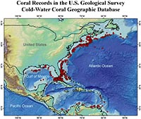
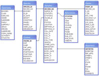
Data CompilationData were compiled from numerous sources, including 20 published reports, 2 museum collections, and 2 previously unpublished sources, for inclusion in the USGS CoWCoG database. All references for entries in this database can be found in Appendix 1 and in the database itself. All data were initially screened to see if accurate supporting information was available, such as how and when the data were collected, who collected the specimen, and who identified it. To maintain data integrity, all data to be entered had to include taxonomy down to family level and geographic positions recorded to within one minute or better to allow for meaningful searches and plotting. Version 1 of this database focuses on the Gulf of Mexico and the northwestern Atlantic Ocean, primarily within the U.S. Exclusive Economic Zone (EEZ) (Fig. 2). These areas were chosen for three reasons: 1) the present high level of interest in this region from U.S. managers, scientists, and non-governmental organizations (NGOs); 2) the wealth of data, including some previously unpublished; and 3) the lack of an existing comprehensive database for this area. Future versions of the database will be expanded to include more of the North Atlantic region and potentially other oceanic realms. In some cases, data for a single entry came from more than one source. For example, we were able to obtain positions and taxonomic information for many entries from Watling and others (2003) but used the online museum databases (for example, the Yale Peabody Museum Collection and National Museum of Natural History Collection) and other publications (such as Deichmann, 1936; Hecker and others, 1980; Theroux and Wigley, 1998; Watling and others, 2005) for additional details about the cruises and collection methods. In these cases, two citations are recorded in the CoWCoG database. This database primarily includes data for the two most common cold-water coral orders – scleractinians and octocorals. Ceriantipatharians and hydroidolinians were also included when they were reported in publications with scleractinians or octocorals, but we did not actively search for them. As a result, few are included in this version; we hope to include more entries from these taxa in future versions. The database is structured to include photographs, and these have been included if non-copyright-protected photos were available. Additional photos from field data and stock photos for each species are planned for a future version. TaxonomyAll taxonomic entries were required to extend to the family level to be included. If a potential entry failed to meet this criterion and further investigation did not result in a reliable identification, the data were discarded. Cnidarian taxonomy, particularly for the cold-water Scleractinia and Octocorallia, is in a constant state of flux. With new species being discovered and old species being synonymized frequently, it was important to find a reliable source for current taxonomic tables. For scleractinian taxonomy, we used the database entitled “Biogeoinformatics of Hexacorals” database (Fautin and Buddemeier, 2006), which is updated on a regular basis and holds a list of current classification, was used. For the octocorals the Biogeoinformatics of Hexacorals database was used to the genus level but another source was consulted for species classification. A combination of other OBIS (Ocean Biogeographic Information System, http://www.iobis.org/about/) databases was used to verify taxonomy, including CoML (Census of Marine Life), ITIS (Integrated Taxonomic Information System), and Species 2000. Positional AccuracyInformation on the accuracy of the navigational system and coral identification is included in the database so that users can select only those data that meet their particular criteria. For example, a scientist planning a cruise might want to use only entries for corals identified by a particular taxonomist and with the most accurate locations, whereas a manager interested in a map showing all the species ever reported in the waters off a particular state may prefer to see all of the data, even if the positions are not highly accurate. To make this easier for the user, a somewhat subjective category named “location quality” was assigned to each entry, with 1 being highest and 3 being lowest. In general, if navigation was by GPS (Global Positioning System), the entry was assigned a 1. If the navigation was by an earlier system such as LORAN or transit satellites it was assigned a 2. Entries assigned a 3 were from cruises in the 1800s or early 1900s or for which no information was available regarding the navigation system. These designations say nothing about the precision of the location; a highly accurate system may have been used, but the location may have been reported with low precision. Available DataEach entry includes a location, taxonomic classification, references, and, when known, details about the cruise and scientists involved in collecting, photographing, and or identifying the coral. See figure 3 for a complete diagram of the database fields and their relationships. Appendix 2 provides a flattened version of the database, with all 96 fields shown for each entry in a spreadsheet without any of the taxonomic or geographic search tools (described in Using the Database) of the database. |