U.S. Geological Survey Open-File Report 2009-1002
Digital Seismic-Reflection Data from Western Rhode Island Sound, 1980
|
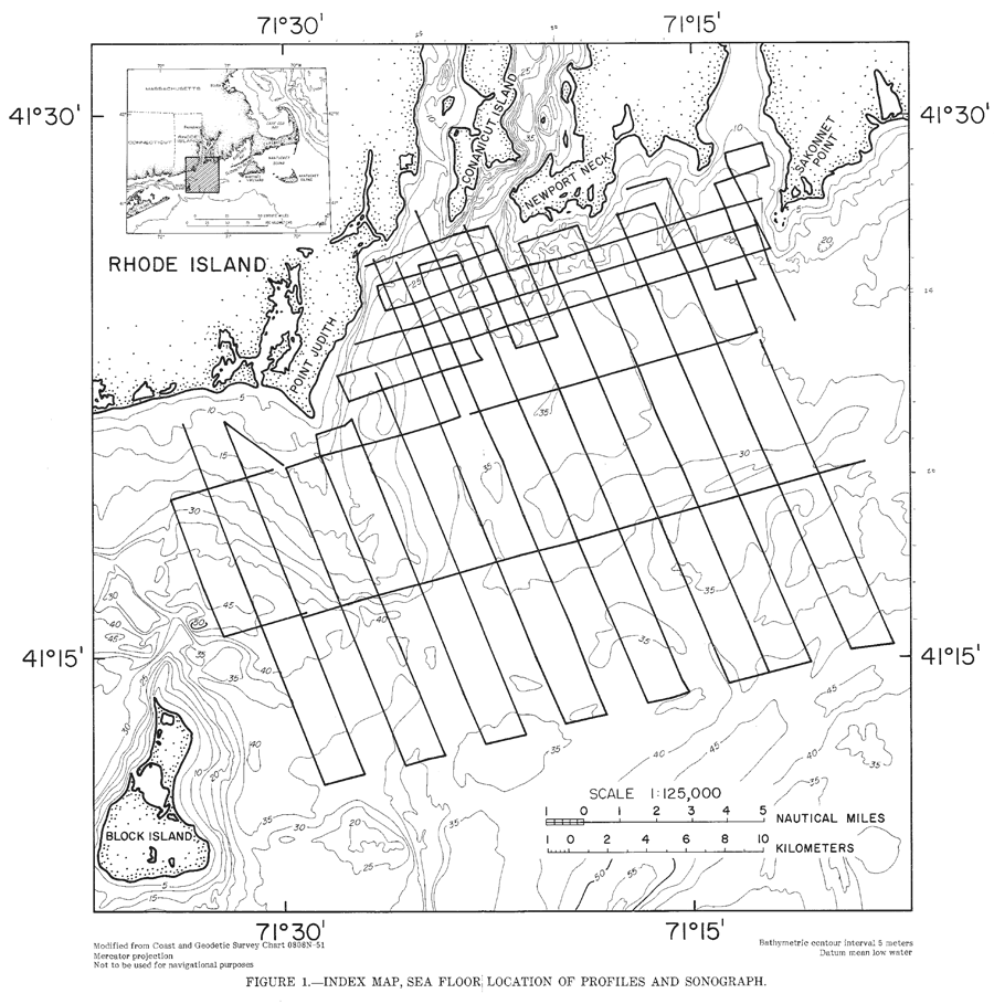
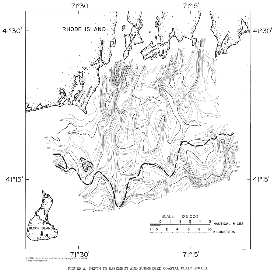
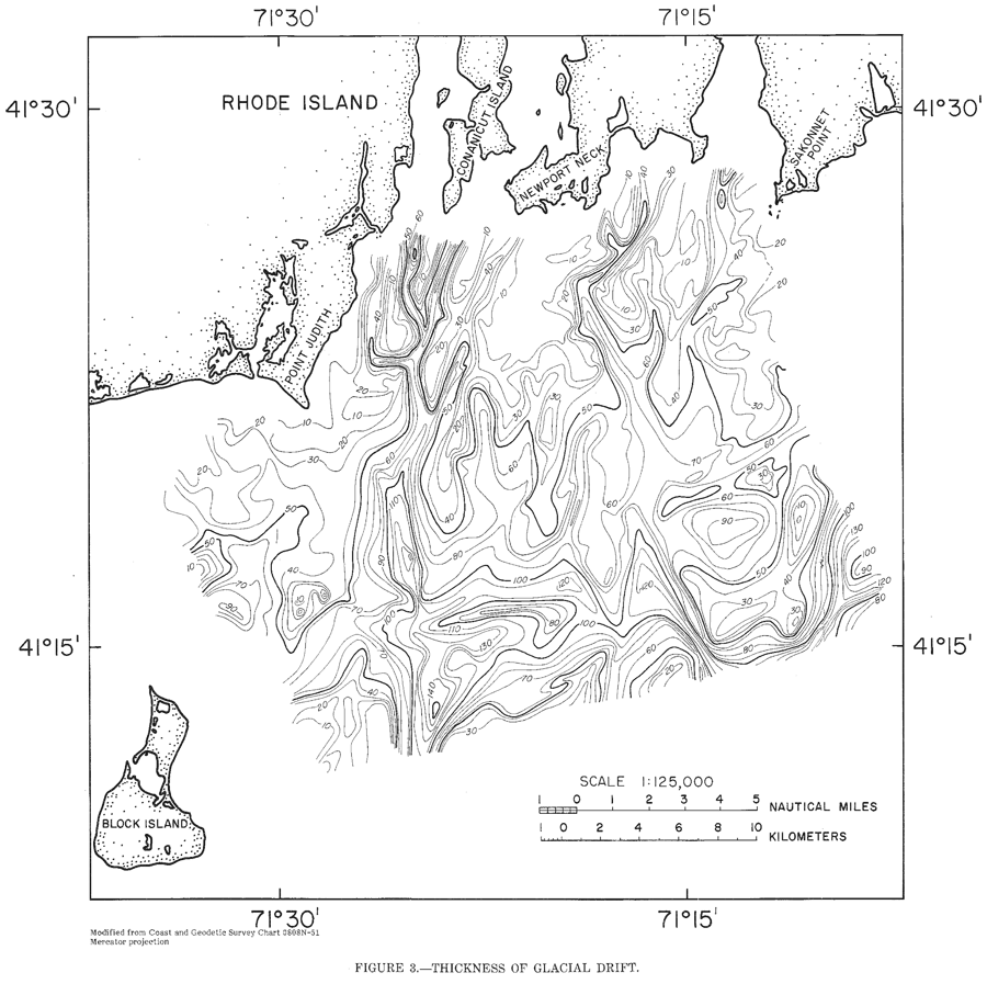
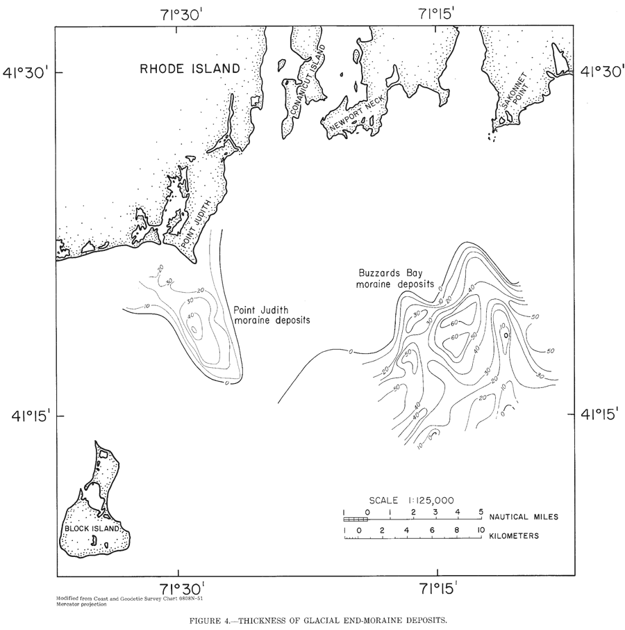
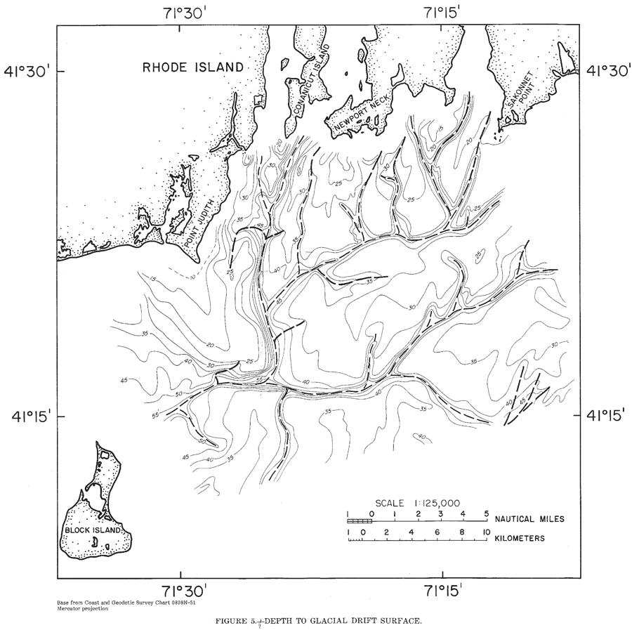
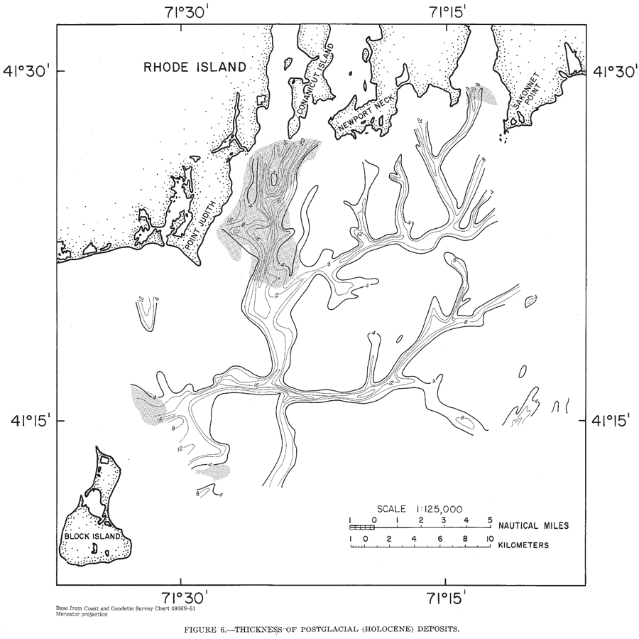
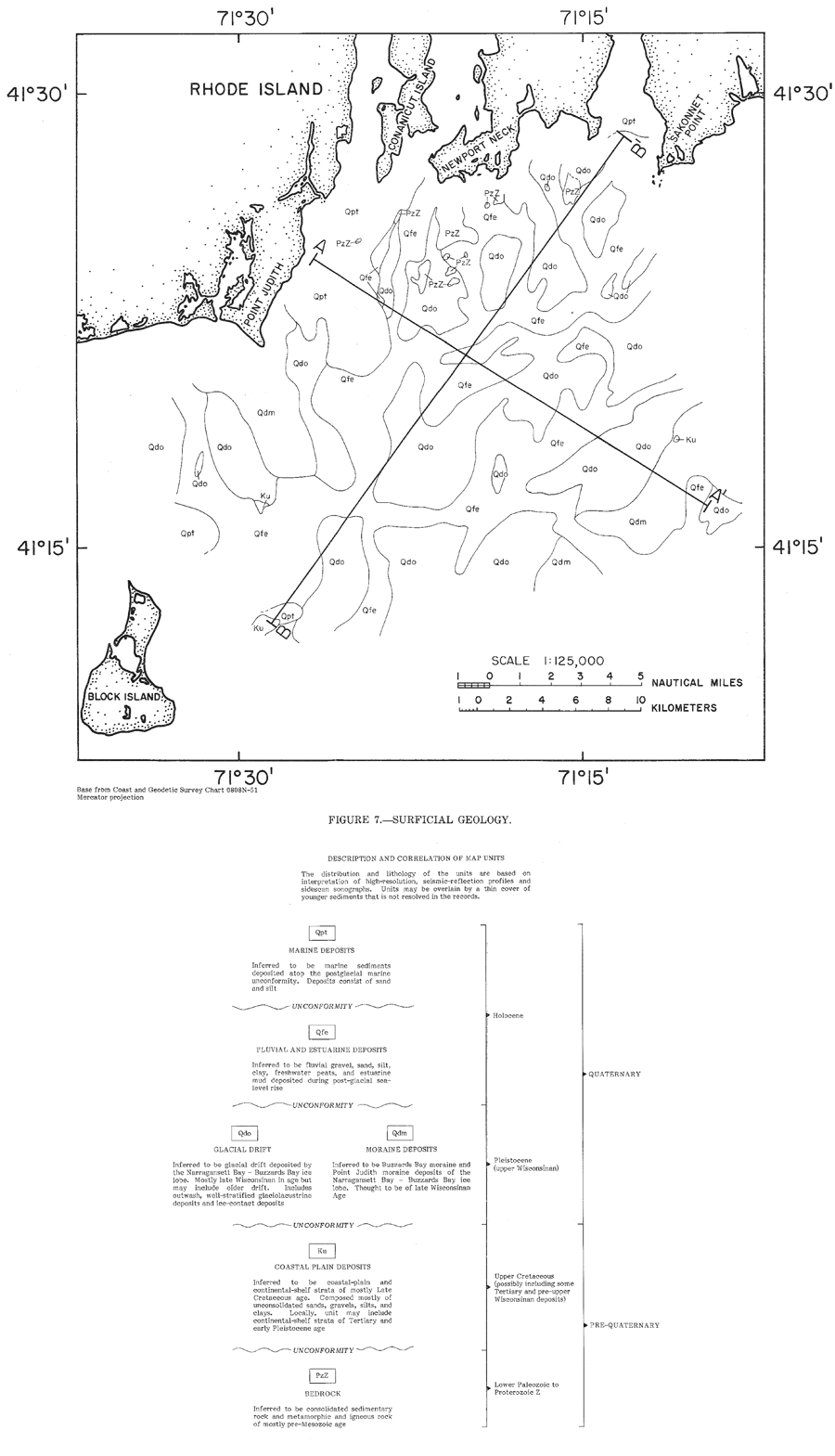
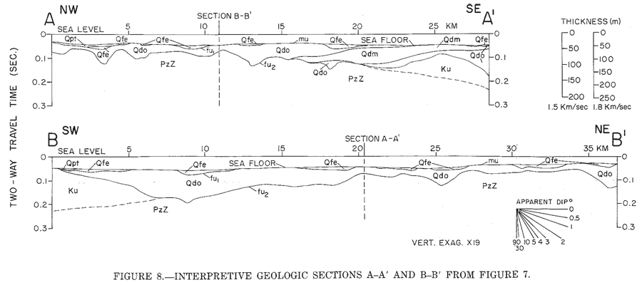
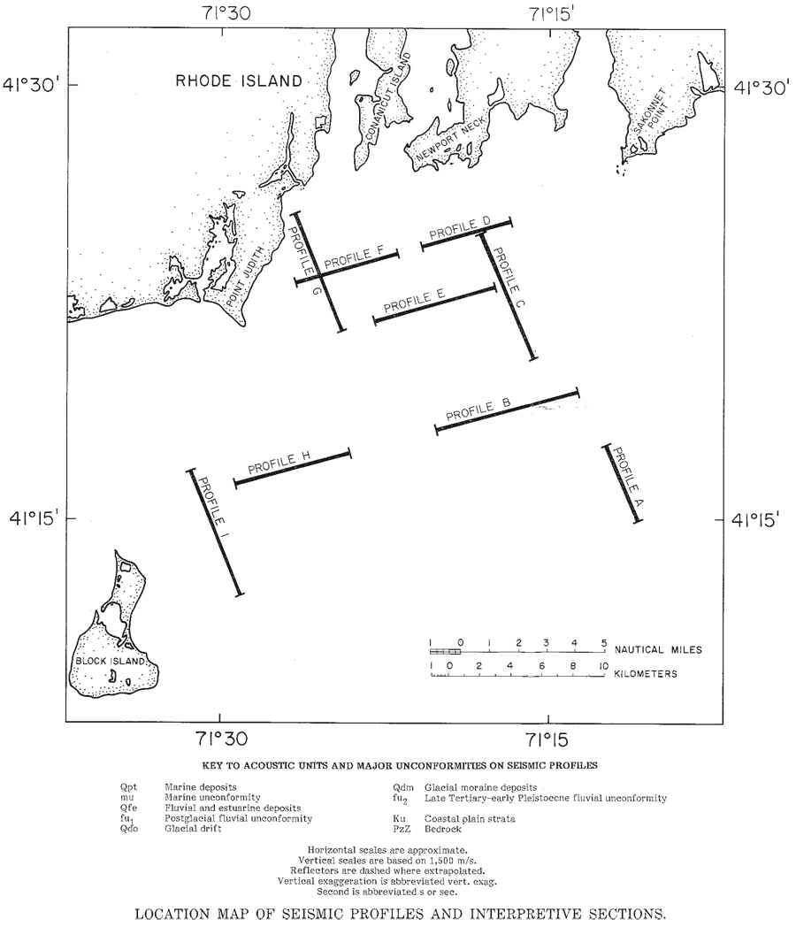
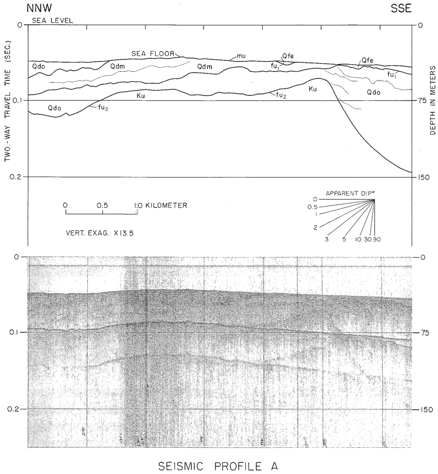
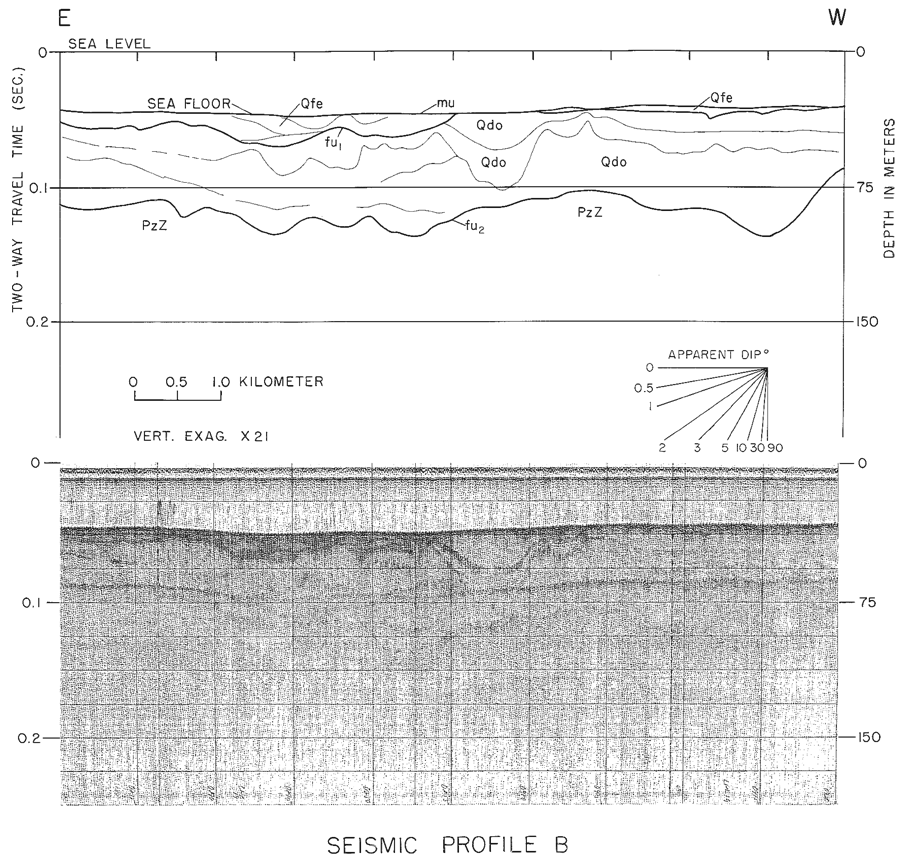
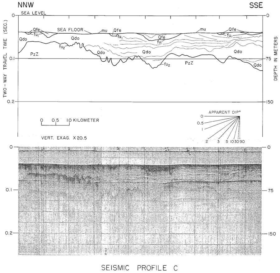
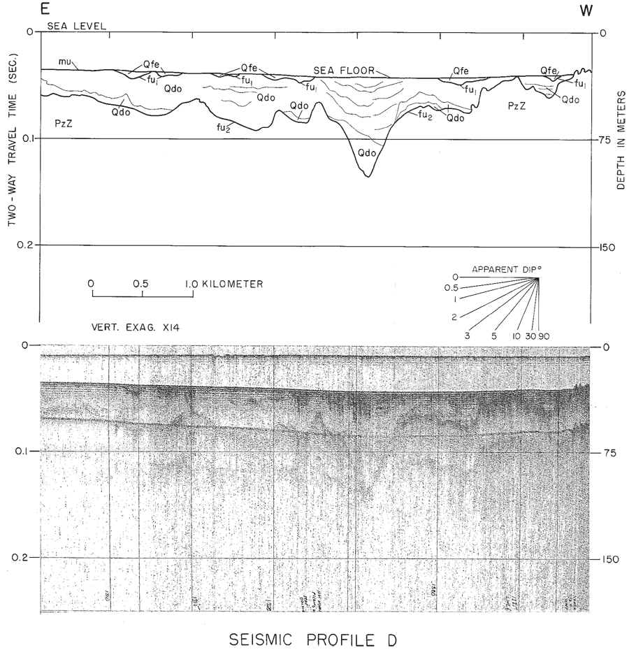
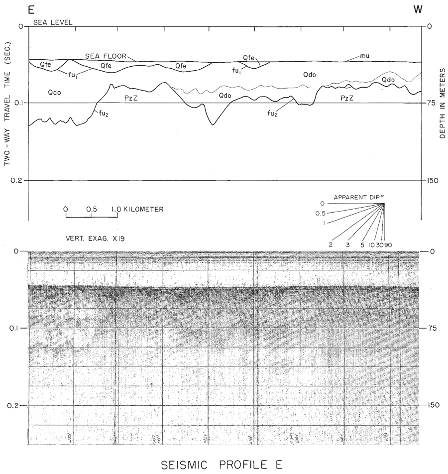
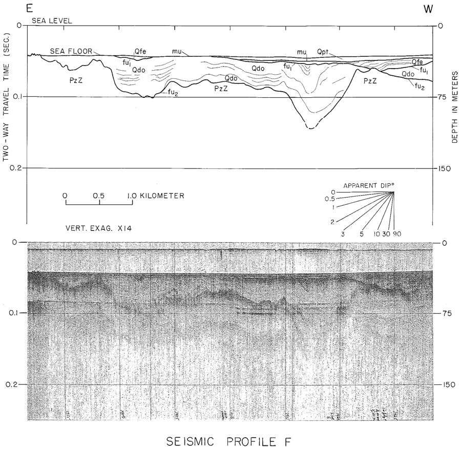
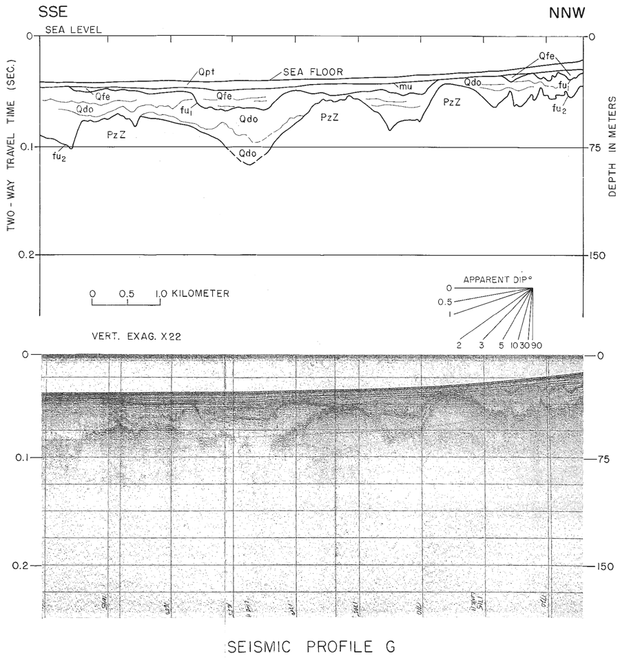
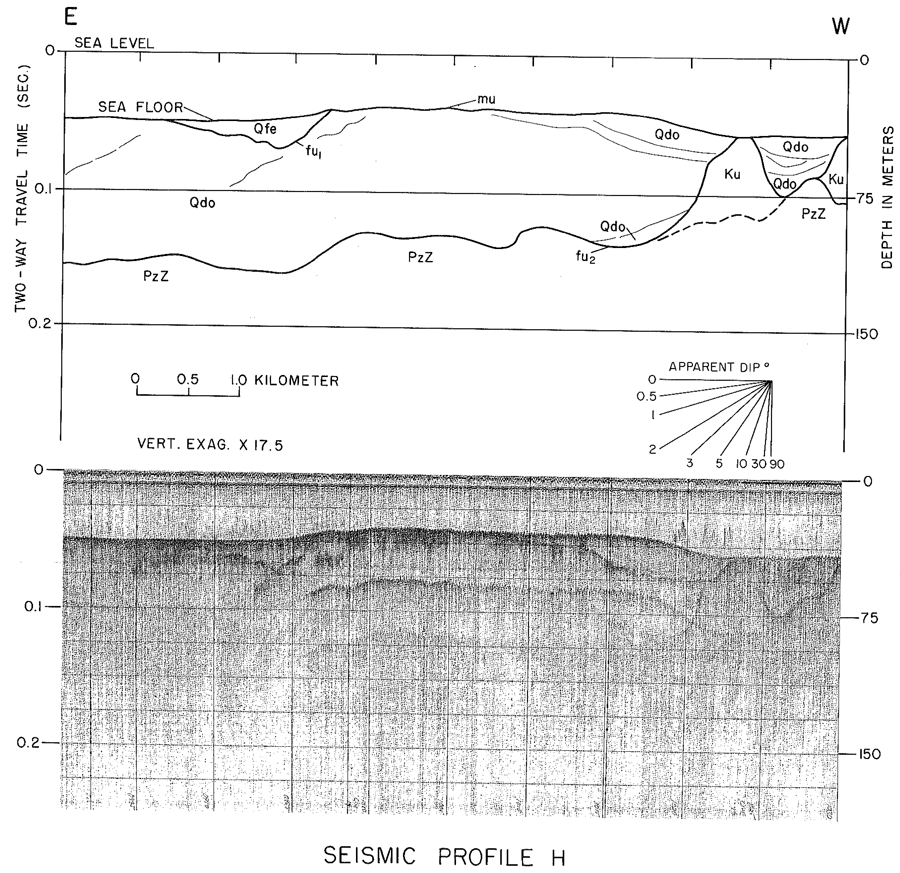
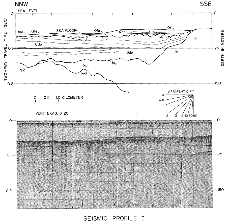
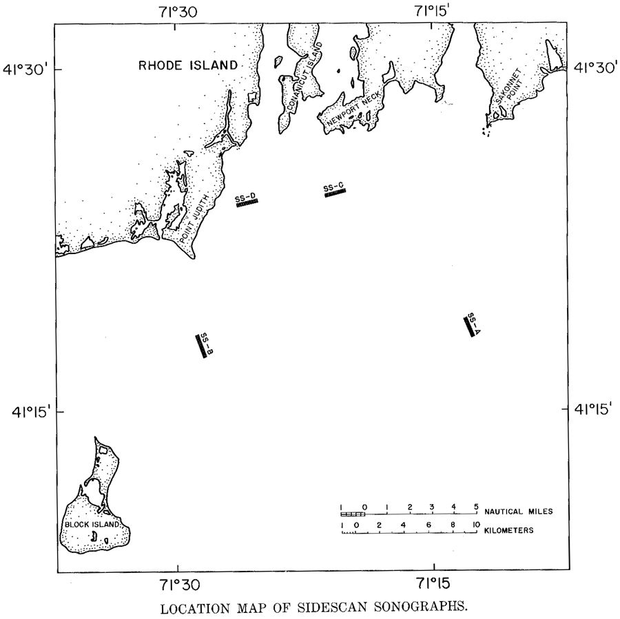
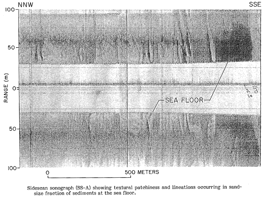
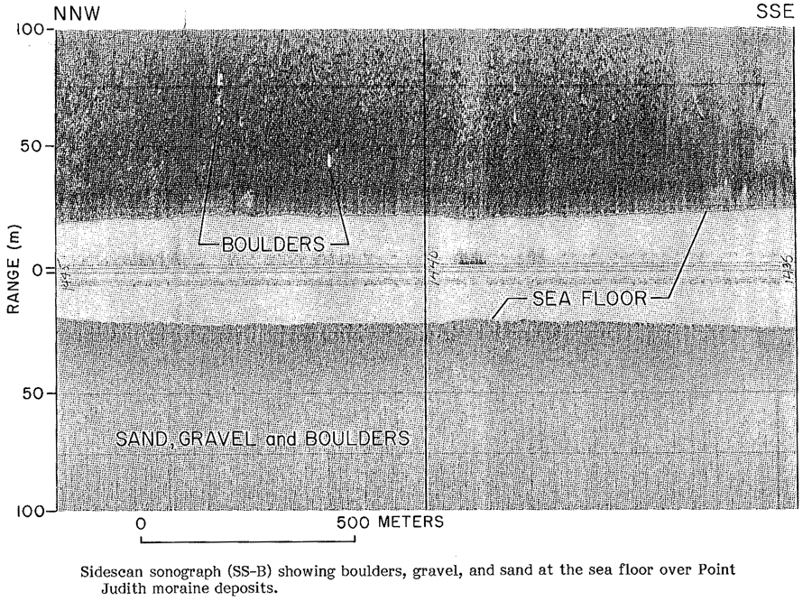
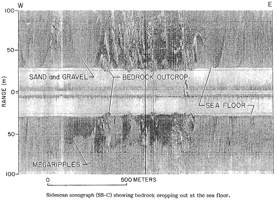
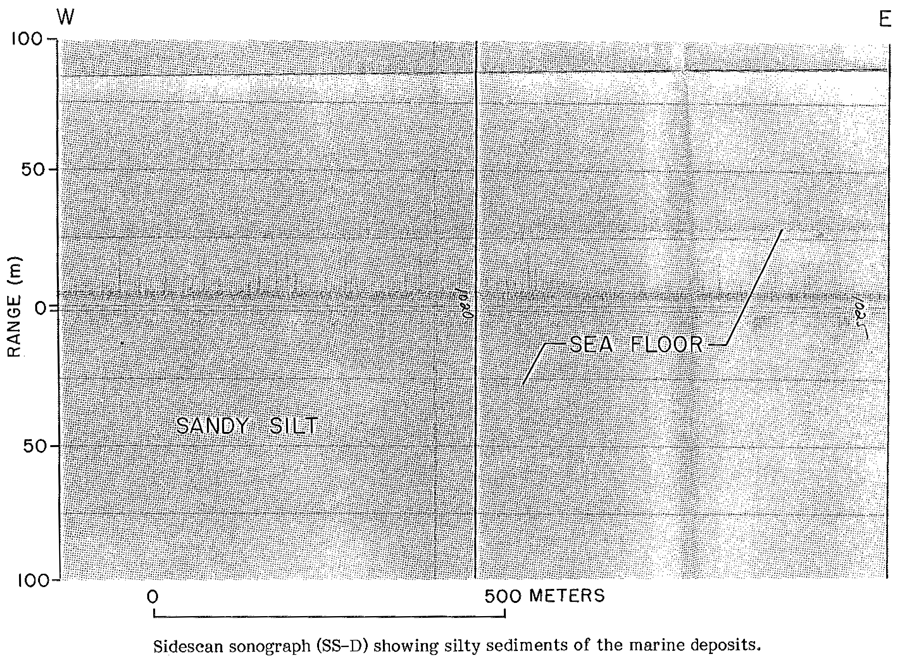
USGS MISCELLANEOUS FIELD STUDIES MAP MF-1537The report presented below (Needell and others, 1983b) was previously published as a Miscellaneous Field Studies Map by the U.S. Geological Survey and is included here solely to broaden the perspective and understanding of those individuals interested in the geologic framework and the Late Quaternary depositional history of Rhode Island Sound. MAPS SHOWING GEOLOGY AND SHALLOW STRUCTURE OF WESTERN RHODE ISLAND SOUND, RHODE ISLAND Sally W. Needell, Charles J. O'Hara, and Harley J. Knebel U.S. Geological Survey Miscellaneous Field Studies Map MF-1537 1983 INTRODUCTION This report presents the results of a high-resolution, seismic-reflection, and sidescan-sonar survey conducted in western Rhode Island Sound south of Narragansett Bay (fig. 1 inset) by the U.S. Geological Survey in 1980. The study defines the geologic framework of the Atlantic Inner Continental Shelf between lat. 41°09' and 41°32'N and long. 71°07' and 71°37'W. A total of 580 kilometers (km) of seismic-reflection profiles and 580 km of sidescan sonographs was collected aboard the RV Neecho. Trackline spacing was 1 to 2 km at the mouth of Narragansett Bay, and dip lines were 2 km apart with widely spaced strike lines in Rhode Island Sound (fig. 1). The maps in this report adjoin those for eastern Rhode Island Sound and Vineyard Sound, Massachusetts, of O'Hara and Oldale (1980). ACKNOWLEDGMENTS The authors wish to thank Jack Bash of the University of Rhode Island for allowing us to use the University docking facility and for providing accommodations during the survey operations. We also wish to thank Susan Pohanka of Colgate University for her assistance in digitizing seismic-reflection data and in preparing preliminary maps. METHODS Subbottom profiles and side-scan sonographs were collected simultaneously. High-resolution, seismic-reflection profiles were collected using an EG&G Uniboom seismic system. Seismic signals were band passed between 400 and 4,000 Hz and were recorded on an EPC facsimile recorder at a quarter-second sweep rate. Seismic resolution was approximately 1 to 2 m. Sidescan sonographs were collected with an EDO Western sidescan-sonar system and were recorded on an EDO facsimile recorder using a 100-meter scan range to each side of the ship. Navigation was by LORAN-C and the ship position was recorded every two minutes. Average ship speed during recording operations was 9.2 km/h (5 knots). The base map (fig. 1) was generated from the U.S. Coast and Geodetic Survey bathymetric map of Block Island and Rhode Island Sounds, number 0808N-51, at a scale of 1:125,000 (U.S. Department of Commerce, 1967). Major acoustic reflectors were interpreted to represent unconformities whose geologic nature was inferred both from outcrops, bottom-sediment samples, and borehole data within the area and in adjacent areas and from stratigraphic positions similar to geologic units in eastern Rhode Island Sound (O'Hara and Oldale, 1980). The depth to the reflectors was determined using an assumed compressional-wave velocity of 1,500 m/s for water and sediments of Holocene age and 1,800 m/s for sediments of Pleistocene age. GEOLOGIC FRAMEWORK The bedrock of Rhode Island and southeastern Massachusetts is predominantly metamorphic and plutonic rock of pre-Mesozoic age except in the eastern third of Rhode Island where several hundred meters of sedimentary and metasedimentary rock of Pennsylvanian age bury the Pennsylvanian Narragansett Basin (Quinn, 1971). This basin, a major structural feature, may extend 16 to 22 km offshore (Miller, 1952; McMaster and others, 1980). The three major bedrock valleys of Narragansett Bay cut into the basin rocks and extend south along the general trend of the metasedimentary rocks (Upson and Spencer, 1964). The general trend of the surrounding rock onshore, however, is northwest (Quinn, 1953). The eroded bedrock surface was unconformably overlain by coastal plain and continental shelf strata during the Late Cretaceous and early Tertiary. These strata, extensively eroded during the late Tertiary and early Pleistocene, occur offshore as a cuesta with a north-facing escarpment which extends from western Long Island Sound to the northern flank of Georges Bank (Weed and others, 1974). During the late Pleistocene, the Laurentide Ice Sheet advanced across the Inner Shelf off southern New England to a terminal position marked by end moraines from Nantucket Island to Long Island (fig. 1 inset; Schafer and Hartshorn, 1965). As the ice advanced, the preglacial landscape was probably only slightly modified, except in major river valleys where thick ice may have overdeepened valley floors (Schafer and Hartshorn, 1965; McMaster and Ashraf, 1973c). As the ice retreated, glacial drift was deposited. A readvance of the ice formed a second system of end moraines from Cape Cod across Rhode Island Sound to Long Island (Schafer, 1961b). After the ice retreated and prior to sea-level rise, the inner shelf was exposed to fluvial erosion. Postglacial valleys were partly filled by fluvial deposits, freshwater peats, and estuarine deposits (O'Hara and Oldale, 1980). As sea level transgressed, the surface sediments were reworked by wave action. Bottom sediments were winnowed by bottom currents and transported offshore or locally deposited over the marine unconformity (Collins, 1976). Sea-floor topography The sea-floor topography of western Rhode Island Sound is varied (fig. 1). A broad, seaward-dipping central depression lies south of Narragansett Bay. It is bounded to the north by an irregular, rocky coast, bedrock ridges, and numerous outcrops, to the west by a ridge that extends 10 km seaward from Point Judith and by Block Island, and to the south by a discontinuous ridge that trends northeast. One of three major depressions that lie adjacent to the central depression is located between Point Judith and Block Island. The other two, a deep and narrow depression trending north, and a deeper, broader depression trending northeast, lie to the south. The sea-floor ridges and depressions reflect the major features of the underlying bedrock and submerged coastal-plain morphology. Glacial erosion and deposition of glacial drift, moraine deposits, and younger deposits have modified the preglacial landscape, as is characteristic of the glaciated shelf of New England (Oldale and Uchupi, 1970). Depth to basement and submerged coastal plain strata Figure 2 shows the depth to the lowest acoustic reflector. The reflector defines a surface inferred to be underlain by crystalline and consolidated sedimentary rock (bedrock) north of the heavy dashed line (fig. 9, unit PzZ in profiles B, C, D, E, F, G, H, and I). South of the line, the depth of the bedrock exceeded the acoustic penetration, and the deepest acoustic reflector is inferred to represent the top of coastal plain and continental shelf strata (fig. 9, unit Ku in profiles A, H, and I). Bedrock Narragansett Bay is underlain by a major structural depression, the Narragansett Basin, that is buried by hundreds of meters of sedimentary and metasedimentary rock of Pennsylvanian age (Quinn, 1971). The basin is thought to extend 16 to 22 km offshore (Miller, 1952; McMaster and others, 1980). The passages of Narragansett Bay and the Sakonnet River are underlain by deep bedrock valleys that cut the basin rock (Upson and Spencer, 1964). However, the bedrock that borders the basin and is exposed along the coast is predominantly plutonic and metamorphic rock of mostly pre-Mesozoic age (Quinn, 1971). Offshore, the Narragansett Basin rocks are thought to be bifurcated by crystalline rock south of Newport Neck (fig. 1, McMaster and others, 1980). Numerous bedrock outcrops are present in the shallow, nearshore waters. The bedrock surface is represented by a prominent, continuous, highly irregular reflector (fig. 9, reflector fu2; in profiles B, C, D, E, F, G, H, and I). The reflector lies at or near the sea floor nearshore (fig. 7, 8, unit PzZ; fig. 10, sonograph SS-C) and can be traced southward to depths up to 180 m, where it passes beneath a thick wedge of coastal plain and continental shelf rocks. The bedrock surface consists of alternating valleys and ridges. Three major bedrock ridges trend south, seaward of Sakonnet Point, Newport Neck, and Point Judith. Deep valleys between the ridges trend generally north. They are extensions of the buried bedrock valleys of the Narragansett Basin. The valleys presumably formed in the more easily eroded sedimentary rock, leaving interfluves of more resistant crystalline rock. The bedrock is overlain in most places by glacial drift of Pleistocene age (fig. 9, unit Qdo in profiles B, C, D, E, F, G, H, and I). Locally it is overlain by fluvial and estuarine deposits (fig. 9, unit Qfe in profile F) and marine deposits of Holocene age. Coastal-Plain Sediments Coastal-plain sediments of Late Cretaceous and early Tertiary age crop out on Block Island (Woodworth and Wigglesworth, 1934; Tuttle and others, 1961; Sirkin, 1976) and on Martha's Vineyard (fig. 1 inset; Woodworth and Wigglesworth, 1934; Kaye, 1964a,b). Unconsolidated nonmarine clays exposed on Block Island have been identified to be of Late Cretaceous age by lithic (Woodworth and Wigglesworth, 1934) and palynologic (Sirkin, 1976) evidence. Seismic data show the unconsolidated sediments to be as much as 260 m thick overlying 230 m of semi-consolidated sediments which may also be Cretaceous in age (Tuttle and others, 1961). Although Tertiary sediments have not been reported, a boulder of Miocene age was found in glacial drift on Block Island (Woodworth and Wigglesworth, 1934). On Martha's Vineyard, a massive bed of clays and greensand identified by lithic evidence to be of Late Cretaceous and Miocene age occurs within a glaciotectonically deformed bed of drift (Woodworth and Wigglesworth, 1934; Kaye, 1964a,b). The landward limit of the coastal-plain strata is defined by a cuesta with a north-facing escarpment that extends from western Long Island to Georges Bank (Weed and others, 1974). The cuesta may underlie the Elizabeth Islands locally and has been traced across eastern Rhode Island Sound approximately 14 km offshore (O'Hara and Oldale, 1980). The surface atop the coastal-plain is represented by a smooth, continuous reflector (fig. 9, reflector fu2 in profiles A, H, and I). Generally, the reflector is deepest (up to 180 m) along its landward limit and shallows seaward. It lies at or near the sea floor in some places (fig. 7,8, unit Ku and fig. 9, profiles H and I). The heavy dashed lines define the landward limit of the cuesta and two outliers of coastal-plain and continental-shelf strata. The escarpment of the cuesta is highly eroded. In the southeastern section of the study area, deep valley floors may be underlain by bedrock. The coastal plain and continental shelf strata are overlain in most places by glacial drift of Pleistocene age (fig. 9, unit Qdo in profiles A, H, and I) and locally by fluvial and estuarine deposits and marine deposits (fig. 9, unit Qpt in profile I) of Holocene age. Tertiary and early Pleistocene drainage The surface shown on the structure-contour map (fig. 2) defines a fluvial and glacial unconformity. The unconformity is inferred to be of late Tertiary to early Pleistocene age because youngest preglacial deposits reported on the southern New England Inner Shelf are Miocene in age. A lowland is defined by the seaward-dipping bedrock surface north of the heavy dashed line and the north-facing escarpment of the cuesta (fig. 2). Streams flowed southward across the bedrock and northward down the escarpment and were tributary to a major river that flowed westward into Block Island Sound. The bedrock and escarpment valleys were deepened and widened by glacial erosion during the Pleistocene (McMaster and Ashraf, 1973a,b,c). Thickness of glacial drift Figure 3 shows the distribution and thickness of the glacial drift (fig. 9, units Qdo and Qdm in profiles A, B, C, D, E, F, G, H, and I). The drift is thought to be primarily of late Wisconsinan Age but may include older drift. Few exposures of drift older than late Wisconsinan Age are reported for Cape Cod, the Elizabeth Islands, or coastal southern New England (Schafer and Hartshorn, 1965), however, older drift has been identified on Long Island, Block Island, Martha's Vineyard, and Nantucket (Woodworth and Wigglesworth, 1934; Kaye, 1964a,b; Sirkin, 1976; Oldale, 1981). The drift was deposited by the Narragansett Bay-Buzzards Bay ice lobe during the advance and retreat of the Wisconsinan ice sheet across the Inner Shelf. Presumably, the drift is composed of till, outwash, and glaciolacustrine deposits similar to the drift sampled in Narragansett Bay (Upson and Spencer, 1964) and eastern Rhode Island Sound (O'Hara and Oldale, 1980). The glacial drift unconformably overlies bedrock (fig. 9, profiles B, C, D, E, F, G, H, and I) in the northern two-thirds of the area and overlies coastal-plain and continental-shelf strata (fig. 9, profiles A, H, and I) in the southern third. The top of the glacial deposits is an unconformity formed by fluvial erosion (fig. 9, reflector fu1 in profiles A, B, C, D, E, F, G, H, and I) during low sea level and by marine erosion during postglacial sea-level rise (fig. 9, reflector mu in profiles A, B, C, D, E, F, G, H, and I). The internal character of the glacial drift is varied. Continuous, flat-lying to gently dipping reflectors probably represent stratified drift deposited by melt-water streams beyond the ice margin. Closely spaced internal reflectors that mimic the unconformity beneath the drift are inferred to represent glaciolacustrine sediments deposited in proglacial lakes. Highly irregular, short, and discontinuous internal reflectors are inferred to be characteristic of tills, ice-contact stratified drift, or drift deformed by overriding ice. Drift covers most of the bedrock and coastal-plain and continental-shelf strata. Drift up to 140 m thick fills the inner lowland and the deep valleys of the bedrock and the coastal-plain escarpment. It is thinnest nearshore, over bedrock highs (for example, the bedrock ridge south of Newport Neck), and atop coastal-plain interfluves. Drift crops out at the sea floor (fig. 7, 8, unit Qdo) except where buried by fluvial and estuarine (fig. 9 profiles A, B, C, D, E, F, G, H, and I) and marine (fig. 9, profiles F, G, and I) deposits of Holocene age. Thickness of glacial end-moraine deposits Figure 4 shows the distribution and thickness of the end-moraine deposits of the Narragansett Bay-Buzzards Bay ice lobe (fig. 9, unit Qdm in profile A). These deposits correlate with the Point Judith moraine deposits and the Buzzards Bay moraine deposits (Schafer, 1961a, b; O'Hara and Oldale, 1980; Oldale, 1981). Buzzards Bay moraine deposits Buzzards Bay moraine deposits crop out on western Cape Cod and the Elizabeth Islands (fig. 1; Mather and others, 1942; Woodworth and Wigglesworth, 1934) and have been traced across western Rhode Island Sound in subbottom profiles (O'Hara and Oldale, 1980). Studies of the internal structure of the moraine and dating of organic material within the deposits indicate that the moraine was formed by a readvance of the Narragansett Bay-Buzzards Bay ice lobe during the final retreat of the late Wisconsinan ice sheet (Woodworth and Wigglesworth, 1934; Schafer, 1961a; Schafer and Hartshorn, 1965; Oldale and O'Hara, 1978; Oldale, 1981; Oldale, written commun., 1981). In the seismic profiles, the base of the moraine deposits is defined by a prominent, continuous, slightly irregular reflector that dips northward. Along the south side of the moraine, the reflection is truncated at or near the sea floor. The top of the deposits lies at or beneath the sea floor (fig. 8, section A-A') and is defined by another northward-dipping, prominent, continuous reflector that, to the north, joins the basal reflector at depth. Northward-dipping, continuous internal reflectors are observed also within the unit. Because the base of the moraine was not observed to the southwest in the seismic-reflection records, the zero contour represents the northern limit of the Buzzards Bay moraine deposits. Bottom samples (McMaster, 1960) and sidescan sonographs across the moraine indicate the presence of boulders, gravel, and coarse sand at the sea floor where the moraine crops out. These sediments are thought to be lag deposits from marine erosion of a till. The moraine deposits vary in thickness from 0 to 60 m. Generally thickest in the central section of the moraine, they thin to the northwest and southeast. The subbottom acoustic reflectors that define the base, top, and prominent internal reflectors of the Buzzards Bay moraine deposits possibly are basal tills deposited as glacial ice overrode previously deposited glacial drift. The moraine may be composed of ice-thrusted sheets of drift and possibly coastal-plain and continental-shelf material similar to the emergent moraine of the Elizabeth Islands (Oldale and O'Hara, 1978; O'Hara and Oldale, 1980; Oldale, written commun., 1981). Point Judith moraine deposits The Point Judith moraine lies onshore as a ridge 8 km long and 1.5 km wide extending north from Point Judith, R.I. (fig. 1; Schafer, 1961a). The moraine is composed of till with thin layers of gravel, sand, and silt, primarily derived from the nearby metasedimentary and crystalline rock of the Narragansett Basin area (Kaye, 1960; Schafer, 1961a). The moraine deposits, ranging in thickness from 3 to 29 m, accumulated as an ablation moraine along the western edge of the Narragansett Bay-Buzzards Bay ice lobe (Schafer, 1961a,b) during the late Wisconsinan (Schafer, 1980). The Point Judith moraine deposits extend to 10 km offshore, overlying a bedrock ridge and locally, overlying older glacial drift. Reflectors inferred to represent the base and top of the moraine show that the base of the moraine is highly irregular and occurs 12 to 50 m below the sea floor. The surface of the moraine lies at the sea floor (fig. 7, unit Qdm) except where unconformably overlain by sediments of Holocene age. Sidescan sonographs (fig. 10, sonograph SS-B) and bottom-sediment samples (McMaster, 1960) show that the deposits are composed of boulders, gravel, and coarse sand at the sea floor. Locally, reflectors within the moraine are highly irregular and discontinuous. Large areas without internal reflectors suggest that much of the moraine is masked by a till cover or is homogeneous in composition. Depth to glacial drift surface After deglaciation of the Rhode Island Inner Shelf and prior to sea-level rise, the glacial drift and outcrops of bedrock and coastal-plain strata were eroded by streams. During the Holocene rise in sea level, the stream-cut channels were filled by fluvial and estuarine sediments. The bottom sediments were reworked subsequently by wave action and bottom currents as the sea transgressed. The glacial drift surface (fig. 5) represents an erosional surface defined by the fluvial unconformity (fu1) and the marine unconformity (mu). In the seismic profiles, the composite unconformity atop the glacial drift is continuous and well-defined. The irregular fluvial unconformity is contiguous with the generally smooth marine unconformity. The fluvial unconformity is overlain by fluvial and estuarine deposits (fig. 9, unit Qfe in profiles A, B, C, D, E, F, G, H, and I) of Holocene age. In most places the marine unconformity corresponds to the sea floor except where overlain by marine deposits of Holocene age (fig. 9, unit Qpt in profiles F, G, and I). The fluvial unconformity is represented by valleys having up to 20 m of relief and thalweg depths of 60 m below sea level (fig. 5). The valleys define a dendritic pattern of postglacial drainage. In the northern section of the study area, the valleys are extensions of buried postglacial valleys of Narragansett Bay and the Sakonnet River (fig. 1). The two major west-trending valleys are part of a drainage system in eastern Rhode Island Sound mapped by O'Hara and Oldale (1980). Drainage was controlled, in part, by the glacial morphology. The Buzzards Bay moraine deposits diverted streamflow to the west and the Point Judith moraine deposits forced streamflow to the south. Thickness of postglacial (Holocene) deposits Fluvial sediments, freshwater peats, and estuarine deposits filled the postglacial stream valleys as the valleys were drowned by rising sea level during the Holocene. The wave action and currents of the transgressing sea reworked the bottom sediments, creating an unconformity that was later covered by marine sediments in some places. Figure 6 shows the thickness and distribution of the postglacial deposits (fig. 9, units Qfe and Qpt in profiles A, B, C, D, E, F, G, H, and I). A stippled pattern shows where the marine unconformity is overlain by marine sediments. The older unit (Qfe) is inferred to consist of fluvial gravel, sand, silt and clay, and freshwater peats overlain by estuarine sand, silt, clay, and marsh deposits similar to the valley fill in eastern Rhode Island Sound and Vineyard Sound (O'Hara and Oldale, 1980) and Buzzards Bay (Robb and Oldale, 1977). In the seismic-reflection profiles, the internal reflectors of the fluvial and estuarine deposits are generally flat-lying to gently dipping and locally are foreset-bedded. The deposits are thickest, up to 20 m, where postglacial valleys are most deeply eroded. The younger unit (Qpt) correlates with the post-marine-unconformity silt and clay and beach- and bar-sand deposits of eastern Rhode Island Sound mapped by O'Hara and Oldale (1980). The seismic reflector at the base of this unit is planar and continuous, whereas the reflector at the surface is slightly irregular and continuous. Internal reflectors, where observed, are continuous and flat-lying. Adjacent to the Rhode Island coast between the entrances to Narragansett Bay and Point Judith, a seaward-thinning wedge of sediments up to 8 m thick overlies the marine unconformity (fig. 9, profiles F and G). Bottom-sediment sampling by McMaster (1960) and sidescan sonographs (fig. 10, sonograph SS-D) show that the deposit is composed of sandy silt and silty sand at the sea floor. The sediments were either transported from Narragansett Bay or eroded from adjacent bottom sediments by bottom currents (McMaster, 1960; Collins, 1976). At the south of the Sakonnet River, the post-transgressive sediments may be fluvial in origin or derived from the Inner Shelf. Sediments offshore are interpreted as beach deposits formed from adjacent bottom sediments that were reworked by waves and currents during sea-level rise and deposited over the marine unconformity. REFERENCES CITED Collins, B.P., 1976, Suspended material transport: Narragansett Bay area, Rhode Island: Estuarine and Coastal Marine Science, v. 4, p. 33-44. Kaye, C.A., 1960, Surficial geology of the Kingston quadrangle, Rhode Island: U.S. Geological Survey Bulletin 1071-1, p.341-396. Kaye, C.A., 1964a, Outline of Pleistocene geology of Martha's Vineyard, Massachusetts: U.S. Geological Survey Professional Paper 501-C, p. C134-C139. Kaye, C.A., 1964b, Illinoian and early Wisconsin moraines of Martha's Vineyard, Massachusetts: U.S. Geological Survey Professional Paper 501-C, p. C140-C143. Mather, K.P., Goldthwait, R.P., and Thiesmeyer, L.R., 1942, Pleistocene geology of western Cape Cod, Massachusetts: Geological Society of America Bulletin, v. 53, p.1127-1174. McMaster, R.L., 1960, Sediments of the Narragansett Bay system and Rhode Island Sound, Rhode Island: Journal of Sedimentary Petrology, v. 30, p. 249-274. McMaster, R.L., and Ashraf, Asaf, 1973a, Subbottom basement drainage system of Inner Continental Shelf off southern New England: Geological Society of America Bulletin, v. 84, p. 187-190. McMaster, R.L., and Ashraf, Asaf, 1973b, Drowned and buried valleys on the southern New England Continental Shelf: Marine Geology, v. 15, p. 249-268. McMaster, R.L., and Ashraf, Asaf, 1973c, Extent and formation of deeply buried channels on the Continental Shelf off southern New England: Journal of Geology, v. 81, p. 374-379. McMaster, R.L., de Boer, Jelle, and Collins, B.P., 1980, Tectonic development of southern Narragansett Bay and offshore Rhode Island: Geology, v. 8, p. 469-500. Miller, E.T., 1952, Inshore marine magnetic investigations—the area from New Jersey to Cape Cod, Massachusetts abs.: Geological Society of America Bulletin, v. 63, p. 1279. O'Hara, C.J., and Oldale, R.N., 1980, Maps showing geology and shallow structure of eastern Rhode Island Sound and Vineyard Sound, Massachusetts: U.S. Geological Survey Miscellaneous Field Studies Map MF-1186, 5 sheets. Oldale, R.N., 1981, Pleistocene stratigraphy of Nantucket, Martha's Vineyard, the Elizabeth Islands, and Cape Cod, Massachusetts, in: Larson, G.J., and Stone, B.D., eds., Late Wisconsinan Glaciation of New England: Dubuque, Kendall/Hunt, p. 1-34. Oldale, R.N., and O'Hara, C.J., 1978, Thrusted coastal end moraines and a Woodfordian fluctuating ice margin; evidence from Massachusetts onshore and offshore areas abs.: Geological Society of America, Abstracts with Programs, v. 10, no. 2, p. 78. Oldale, R.N., and Uchupi, Elazar, 1970, The glaciated shelf off northeastern United States: U.S. Geological Survey Professional Paper 700-B, p. B167-B173. Quinn, A.W., 1953, Bedrock geology of Rhode Island: New York Academy of Science Transactions, series 2, v. 15, p. 264-269. Quinn, A.W., 1971, Bedrock geology of Rhode Island: U.S. Geological Survey Bulletin 1295, 68 p. Robb, J.M., and Oldale, R.N., 1977, Preliminary geologic maps, Buzzards Bay, Massachusetts: U.S. Geological Survey Miscellaneous Field Studies Map MF-889, 2 sheets. Schafer, J.P., 1961a, Surficial geology of the Narragansett Pier quadrangle, Rhode Island: U.S. Geological Survey Geologic Quadrangle Map GQ-140. Schafer, J.P., 1961b, Correlation of end moraines in southern Rhode Island: U.S. Geological Survey Professional Paper 424-D, p. D68-D70. Schafer, J.P., 1980, The last ice sheet in Rhode Island abs.: Geological Society of America, Abstracts with Programs, v. 12, no. 2, p. 80. Schafer, J.P., and Hartshorn, J.H., 1965, The Quaternary of New England, in Wright, H.E., Jr., and Frey, D.G., eds., The Quaternary of the United States: Princeton, NJ, University Press. p. 113-128. Sirkin, Les, 1976, Block Island, Rhode Island; evidence of fluctuation of the late Pleistocene ice margin: Geological Society of America Bulletin, v. 87, p. 574-580. Tuttle, C.R., Allen, W.B., and Hahn, G.W., 1961, A seismic record of Mesozoic rocks on Block Island, Rhode Island: U.S. Geological Survey Professional Paper 424-C, p. C254-C256. U.S. Department of Commerce, 1967, Bathymetric map of Block Island and Rhode Island Sounds: C.&G.S. chart 0808N-51, Mercator projection, scale 1:125,000. Upson, J.E., and Spencer, C.W., 1964, Bedrock valleys of the New England coast as related to fluctuations of sea level: U.S. Geological Survey Professional Paper 454-M, 44 p. Weed, E.G.A., Minard, J.P., Perry, W.J., Jr., Rhodehamel, E.C., and Robbins, E.I., 1974, Generalized pre-Pleistocene geologic map of the northern United States Atlantic continental margin: U.S. Geological Survey Miscellaneous Investigations Series Map I-861, scale 1:1,000,000. Woodworth, J.B., and Wigglesworth, Edward, 1934, Geography and geology of the region including Cape Cod, the Elizabeth Islands, Nantucket, Martha's Vineyard, No Mans Land and Block Island: Harvard College Museum of Comparative Zoology Memoir, v. 52, 322 p. |

![]() U.S. Department of the Interior |
U.S. Geological Survey
U.S. Department of the Interior |
U.S. Geological Survey
URL: https://pubsdata.usgs.gov/pubs/of/2009/1002/html/wris_sum.html
Page Contact Information: Contact USGS
Page Last Modified: Wednesday, 07-Dec-2016 21:55:56 EST