U.S. Geological Survey Open-File Report 2010–1005
Surficial Geology of the Sea Floor in Long Island Sound Offshore of Plum Island, New York
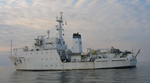
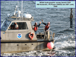
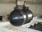
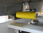
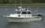
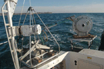
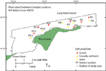
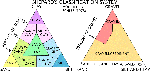
Bathymetric and Sidescan-Sonar DataBathymetric and sidescan-sonar data were acquired during hydrographic survey H11445 on the NOAA Ship Thomas Jefferson from September 16 to October 1, 2008 (fig. 3). The data were collected on two 8.5-meter (m) aluminum launches (3101 and 3102) deployed from the Thomas Jefferson (fig. 4). All positioning was determined by differential global positioning system (DGPS) navigation systems. Vertical datum is mean lower low water. Detailed information on ship specifications and equipment, as well as bathymetry and sidescan-sonar acquisition and processing procedures, are located in the H11445 Descriptive Report (National Oceanic and Atmospheric Administration, 2008). Bathymetric data were acquired with RESON SeaBat 8101 and 8125 multibeam echosounders (operating at frequencies of 240 kilohertz (kHz) and 455 kHz, respectively) hull-mounted on the two launches (figs. 5 and 6). The data were acquired in extended Triton data format (XTF) and recorded digitally through an ISIS data acquisition system. The data were processed by using CARIS Hydrographic Image Processing System (HIPS) software to perform a quality assessment and to incorporate sound velocity and tidal corrections. Sound velocity corrections were derived from frequent SEACAT conductivity-temperature-depth (CTD) profiles. Typically, a CTD cast was conducted every 3 to 4 hours of multibeam acquisition. Tidal zone corrections were calculated from data acquired at the New London, Thames River, CT, tidal gage. The vertical resolution of the multibeam data is approximately 0.5 percent of the water depth. The data were gridded to 2-m resolution and saved as a CARIS HIPS database. An Environmental Systems Research Institute (ESRI) grid was created by using IVS Fledermaus and ArcGIS software. A 4X vertically exaggerated, hill-shaded image (illuminated from 0° north at an angle of 55°) was created by using IVS Fledermaus software. The sidescan-sonar data were acquired with a Klein 5000 sidescan-sonar system, hull-mounted to launch 3102 (fig. 7). The system was set to sweep 100 m to either side of the launch tracks. The system has a vertical beam angle of 40° and transmits at 455 kHz. The data were acquired in XTF, recorded digitally through a Triton ISIS data acquisition system, and processed using CARIS Sidescan Image Processing System (SIPS) software to perform a quality assessment, and to produce a composite sidescan-sonar image at 1-m horizontal resolution. As part of this process, the sidescan-sonar data were demultiplexed and filtered to remove speckle noise and to correct for slant-range distortions. Image 'shine through', to account for areas of overlap, and auto-contrast adjustment were applied. The final mosaic was projected from UTM Zone 18 to WGS84 geographic coordinate systems to produce the final enhanced images in both local and geographic coordinates. Backscatter tones have been inverted from the original image, such that lighter tones indicate higher acoustic reflectivity and darker tones indicate lower acoustic reflectivity. Sediment Samples and Bottom PhotographyU.S. Geological Survey cruise 09059 on the research vessel (R/V) Rafael collected still and video photography and sediment samples from the study area during November 2009 (fig. 8). The small Seabed Observation and Sampling System (SEABOSS), a modified Van Veen grab sampler with attached still and video cameras, collected samples and photographs at 13 stations (figs. 9 and 10). Photography was used to help characterize the sea-floor environments, observe floral and faunal communities, and view gravel and boulder environments where samples could not be taken. A gallery of sea-floor images collected during the cruise is in the Bottom Photography section and location information of each photograph is in the Data Catalog. Surficial sediment samples, obtained from the top two centimeters of the sea floor, were taken at six of the stations in the study area; the other seven stations were located in areas that were too rocky to retrieve a sample and were classified as gravel based on field observations. Grain-size analysis of the sediment samples was performed by using sieves and a Coulter Counter. Samples were wet-sieved to separate the coarse (diameters greater than or equal to 0.0625 millimeters) and fine (diameters less than 0.0625 millimeters) fractions. The fine fraction was analyzed with a Coulter Counter; the coarse fraction was analyzed by dry-sieving. Sediment descriptions are based on Wentworth's (1922) nomenclature and Shepard's (1954) size classifications (figs. 11 and 12). For detailed information on grain-size analysis procedures see Poppe and others (2005). Grain-size analysis data are presented in the Sediments and Data Catalog sections of this report. Interpretations presented in this report are based on bathymetric, sidescan-sonar, sediment, and photographic data. Bedforms are characterized based on morphology and height. Sand waves are higher than 1 m; megaripples are 0.2 to 1 m high; ripples are less than 0.2 m high (Ashley, 1990). Bathymetric data are not to be used for navigation. To view files in PDF format, download a free copy of Adobe Reader. |

![]() U.S. Department of the Interior |
U.S. Geological Survey
U.S. Department of the Interior |
U.S. Geological Survey
URL: https://pubsdata.usgs.gov/pubs/of/2010/1005/html/methods.html
Page Contact Information: Contact USGS
Page Last Modified: Wednesday, 07-Dec-2016 22:35:43 EST