Skip past header information
USGS - science for a changing world
NOAA Logo with link to NOAA Home Page.CT DEP Logo with link to CT DEP Home Page.  

U.S. Geological Survey Open-File Report 2010–1005

Surficial Geology of the Sea Floor in Long Island Sound Offshore of Plum Island, New York


Bathymetry

Skip past contents information
Click on figures for larger images
Thumbnail image of figure 13 and link to larger figure. A map showing hill-shaded multibeam bathymetry obtained during National Oceanic and Atmospheric Administration survey H11445. Warmer colors are shallower areas and cooler colors are deeper areas. Boxes show locations of figures 14, 16, 18, and 20.
Figure 13. Hill-shaded multibeam bathymetry obtained during National Oceanic and Atmospheric Administration survey H11445.
Thumbnail image of figure 14 and link to larger figure. An Illustration showing detailed multibeam bathymetry near Plum Gut, the channel between Orient Point and Plum Island. The sea floor in the channel is hummocky, while the surrounding sea floor is relatively smooth. A tractor-trailer wreck is located in Plum Gut. Location of image shown in figure 13.
Figure 14. Detailed multibeam bathymetry near Plum Gut, the channel between Orient Point and Plum Island.
Thumbnail image of figure 15 and link to larger figure. A map showing the interpretation of multibeam bathymetry and sidescan sonar from National Oceanic and Atmospheric Administration survey H11445. Delineated areas include boulders (red) and sand waves (orange). A wreck, a tractor trailer, is located southwest of Plum Island.
Figure 15. Interpretation of multibeam bathymetry and sidescan sonar from National Oceanic and Atmospheric Administration survey H11445.
Thumbnail image of figure 16 and link to larger figure. An illustration showing detailed multibeam bathymetry of sand waves on the shoal north of Plum Island. Wave asymmetries indicate counter-clockwise net sediment transport maintains the shoal. Boulders are present near the shore. Location of image shown in figure 13.
Figure 16. Detailed multibeam bathymetry of sand waves on the shoal north of Plum Island.
Thumbnail image of figure 17 and link to larger figure. A diagram showing sand-wave profiles of waves on shoal north of Plum Island. Arrows show direction of net sediment transport. Profile A shows waves with asymmetries suggesting a westward net sediment transport. Profiles B and C show waves with asymmetries suggesting an eastward net sediment transport. Profile D shows waves that are symmetrical and are probably not moving. Vertical exaggeration is 6X in profiles A-C and 7X in profile D. Locations of profiles shown in figure 16.
Figure 17. Sand-wave profiles of waves on shoal north of Plum Island.
Thumbnail image of figure 18 and link to larger figure. An illustartion showing detailed multibeam bathymetry image of boulders north of Plum Island, which are part of the Harbor Hill-Roanoke Point-Charlestown-Buzzards Bay moraine. Location of image shown in figure 13.
Figure 18. Detailed multibeam bathymetry image of boulders north of Plum Island, which are part of the Harbor Hill-Roanoke Point-Charlestown-Buzzards Bay moraine.

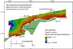
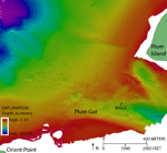
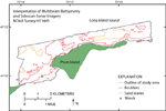
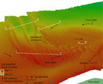
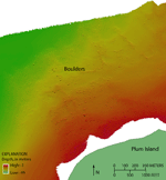
The sea floor in the study area ranges from 1 to 103 m in depth (fig. 13). The deepest area is an isolated depression caused by tidal scour with depths exceeding 100 m. It is located northwest of Plum Island at the northwest corner of the study area. Plum Gut, the channel between Plum Island and Orient Point, is another relatively deep area reaching about 60 m (fig. 14). The sea floor in Plum Gut is hummocky, likely due to currents scouring the submerged moraine in the constricted channel. The shallowest areas occur along the shoreline and north of the eastern arm of Plum Island, on a sand-wave-covered shoal that shallows to about 7 m. In other areas north of Plum Island, the sea floor gradually deepens offshore and is relatively smooth where boulders are not present. Sand waves on the shoal cover an area of 1.4 km² (fig.15). Asymmetries of the sand waves on the western and southern parts of the shoal indicate eastward net sediment transport, while in the northeast they indicate westward net sediment transport (figs. 16 and 17). A boulder on the northeast flank of the shoal exhibits scour marks that indicate westward sediment transport (fig. 16). It is presumed that this counterclockwise movement of sand helps to maintain the shoal. Barchanoid sand waves are located along an east-west transect through the center of the shoal. Four smaller areas (0.1 to 0.2 km²) of sand waves and megaripples surround the basin in the northwest part of the study area (fig. 15). The crests of these sand waves and megaripples tend to be oriented east-west, though those in the southernmost area are oriented northwest-southeast.

Large areas of boulders, covering several square kilometers, flank the shore north of Plum Island and Orient Point (fig. 18). These boulders, some of which reach several meters wide, are a lag deposit of the Roanoke Point-Orient Point-Fishers Island moraine system (Sirkin, 1980). Some of the boulders have scour marks indicating sediment transport directions that are generally eastward. A wreck, a tractor trailer that fell off a ferry in 2002, is visible in the bathymetry imagery in Plum Gut (figs. 14 and 15; National Oceanic and Atmospheric Administration, 2008).


Accessibility FOIA Privacy Policies and Notices

Take Pride in America logo USA.gov logo U.S. Department of the Interior | U.S. Geological Survey
URL: https://pubsdata.usgs.gov/pubs/of/2010/1005/html/bathy.html
Page Contact Information: Contact USGS
Page Last Modified: Wednesday, 07-Dec-2016 22:35:28 EST