Skip past header information
USGS - science for a changing world
NOAA Logo with link to NOAA Home Page.CT DEP Logo with link to CT DEP Home Page.  

U.S. Geological Survey Open-File Report 2010–1005

Surficial Geology of the Sea Floor in Long Island Sound Offshore of Plum Island, New York


Sidescan Sonar

Skip past contents information
Click on figures for larger images
Thumbnail image of figure 19 and link to larger figure. A map showing sidescan-sonar imagery from National Oceanic and Atmospheric Administration survey H11445.Lighter tones represent high backscatter and darker tones represent low backscatter.
Figure 19. Sidescan-sonar imagery from National Oceanic and Atmospheric Administration survey H11445.
Thumbnail image of figure 20 and link to larger figure.An illustration showing detailed sidescan-sonar image of sand waves and boulders in the study area. Also shown are high backscatter (lighter tones) and low backscatter (darker tones). Location of image shown in figure 13.
Figure 20. Detailed sidescan-sonar image of sand waves and boulders in the study area.
Thumbnail image of figure 21 and link to larger figure. Photograph of the sea floor at station PI12 showing a boulder encrusted with sponges, anemones, and hydrozoans. Boulders and gravel on the sea floor are indicated by high backscatter in sidescan-sonar imagery.
Figure 21. Photograph of the sea floor at station PI12 showing a boulder encrusted with sponges, anemones, and hydrozoans.
Thumbnail image of figure 22 and link to larger figure. Photograph of the sea floor at station PI10 showing a gravelly environment. Gravel on the sea floor is indicated by high backscatter in sidescan-sonar imagery.
Figure 22. Photograph of the sea floor at station PI10 showing a gravelly environment.
Thumbnail image of figure 23 and link to larger figure. Photograph of the sea floor at station PI7 showing a sandy environment and a spider crab. Low backscatter in sidescan-sonar imagery from the study area indicates a sandy sea floor.
Figure 23. Photograph of the sea floor at station PI7 showing a sandy environment and a spider crab.

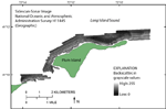
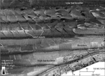
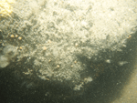
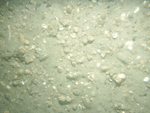
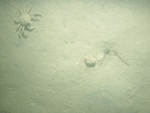
The sidescan-sonar image only covers part of the study area. Areas of higher backscatter appear as lighter tones and are interpreted as consisting of coarser grained material capable of reflecting large amounts of sonar waves. Areas of lower backscatter appear as darker tones and are interpreted as consisting of finer grained materials (fig. 19).

Individual objects of high backscatter with low-backscatter shadows are interpreted as boulders. Tiger-striped patterns of high and low backscatter are produced by sand-wave fields (fig. 20). Both of these features are also visible in the bathymetric imagery and they are further discussed in the Bathymetry section of this report. In the study area, higher backscatter occurs where there is gravel or gravelly sediment on the sea floor, such as at stations 12 and 10 (figs. 21 and 22). Lower backscatter occurs where sand is present, such as at station 7 (fig. 23). High backscatter tends to dominate the survey area, especially near the shore. Low backscatter regions are located north of Orient Point and on the shoal north of the eastern end of Plum Island.


Accessibility FOIA Privacy Policies and Notices

Take Pride in America logo USA.gov logo U.S. Department of the Interior | U.S. Geological Survey
URL: https://pubsdata.usgs.gov/pubs/of/2010/1005/html/sonar.html
Page Contact Information: Contact USGS
Page Last Modified: Wednesday, 07-Dec-2016 22:35:48 EST