U.S. Geological Survey Open-File Report 2010–1005
Surficial Geology of the Sea Floor in Long Island Sound Offshore of Plum Island, New York
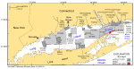
The U.S. Geological Survey (USGS), the Connecticut Department of Environmental Protection (CT DEP), and the National Oceanic and Atmospheric Administration (NOAA) have been working cooperatively to map coastal areas of the Northeastern United States. Prior sea-floor surveys in Long Island Sound (fig. 1) include the previous efforts of NOAA and USGS/CT DEP to survey all of the Long Island Sound sea floor. During September and October of 2004, NOAA completed hydrographic survey H11445 north of Plum Island, New York (fig. 1). The survey, almost 12 square kilometers (km²) in area, includes 11.5 km² of multibeam-bathymetric data and 6 km² of sidescan-sonar data. To better interpret the remote sensing data, the USGS completed a ground-truth survey in this area during November 2009, which consisted of 13 stations where bottom photographs, video, and sediment samples were collected. Together the acoustic and verification data are used to characterize and delineate sea-floor features and environments. Data provided in this report include: bathymetric grids and imagery; sidescan-sonar imagery; bottom photographs; sediment textural data; and an interpretative data layer that can be displayed in a geographic information system (GIS). This information is useful for benthic habitat studies and provides a framework for future management activities. |

![]() U.S. Department of the Interior |
U.S. Geological Survey
U.S. Department of the Interior |
U.S. Geological Survey
URL: https://pubsdata.usgs.gov/pubs/of/2010/1005/html/intro.html
Page Contact Information: Contact USGS
Page Last Modified: Wednesday, 07-Dec-2016 22:35:44 EST