
Core Collection and Radiometric Dating in Deep Creek Lake, Garrett County, Maryland, 2007-08
By William S.L. Banks and Allen C. Gellis
Introduction
Thirty-four sediment cores were collected from Deep Creek Lake in Garrett County, Maryland, between June 9 and 11, 2008 (fig. 1). The primary objective of collecting sediment cores was to estimate the thickness of the sediment that has accumulated on the lake bed since construction of the lake in 1925. The cores also were used to calculate sedimentation rates through the analysis of cesium-137 (137Cs) and to determine sediment grain size as a function of depth. Cores were located in areas where sediment accumulation was expected to be greatest--in coves and downgradient of streams draining into the lake. Additionally, core-collection equipment could only be used in relatively shallow water (less than 30 feet or ft deep), which prevented collection of samples in the central part of the lake.
Click the green sites to view data
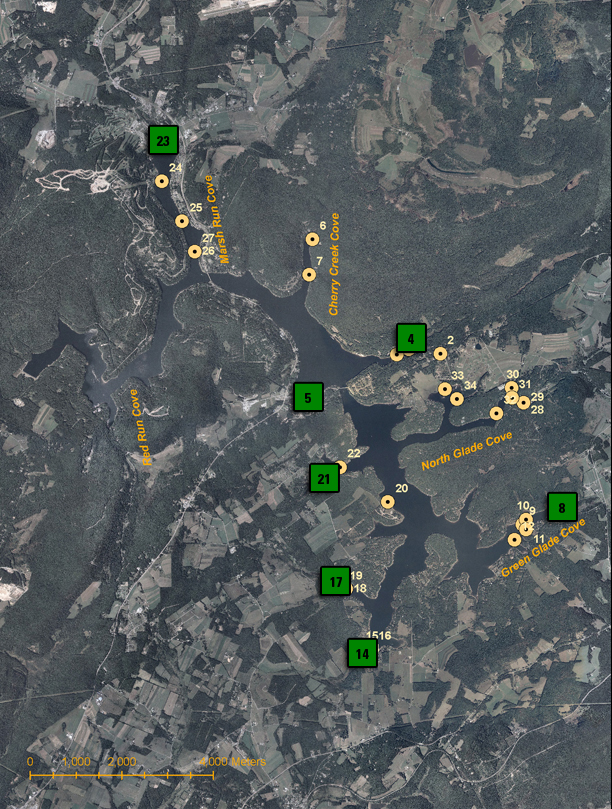
Figure 1. Location of sediment cores collected on Deep Creek Lake, Garrett County, Maryland, 2008.
Methods
All cores were collected from an aluminum-hulled work boat. The methods and tools used to collect cores varied according to water depth. Depths greater than 15 ft required that the field crew use a gravity core. Gravity cores were collected using a 5-ft-long, 3-in. (inch)-diameter stainless-steel barrel with a 2-in. polybuterate liner. The top of the barrel houses a check valve to allow water to flow out during insertion of the barrel into the lake bottom. The valve can be remotely closed once the core is in place to help retain sediment as the barrel is removed from the lake bottom and lifted through the water column.
The bottom of the barrel is fitted with a tapered bit that is designed to push through bottom material while minimally disturbing the surrounding material, and a core catcher that helps retain sediment. Typically, the core barrel was lowered through the water column and held nearly vertical as a 5-lb (pound) hammer weight was raised and lowered by means of a line to drive the core barrel into the bottom sediments. Maximum penetration was generally achieved after 20 hammer blows. To retrieve the core, the check valve was closed by means of a line from the surface and a line attached to the sampler was attached to an on-board winch and davit to pull the core barrel from the lake bottom. Prior to the bottom of the barrel breaking the surface of the water, the liner was removed and capped. Sedimentation rates were not corrected for core shortening, which may occur when gravity cores are used on very soft sediments (Blomqvist, 1985).
In shallow water (less than 15 ft deep), the field crew used a slide hammer to drive the stainless-steel core barrel into the lake bottom until the top of the core barrel was near or at the water surface or until the barrel met refusal. Depending on the water depth, the stainless-steel core barrel was fitted with up to four 5-ft stainless-steel core barrel extensions along with the bit, core catcher, and liner, and was lowered into the water until the assembly contacted the lake floor. Once in place, an 80-lb slide hammer was lowered over the coring assembly and raised and dropped as few as 1 and as many as 10 times. This method did not require the use of a check valve to contain the core, as cores collected in this manner penetrated material to a sufficient depth so that the end of the core barrel was filled with clay or a clay-gravel mix. As with the gravity core method, the barrel assembly was removed by a winch and davit and the core barrel was capped before breaking the water surface. Although a tapered bit was used in an attempt to minimize core shortening, some core shortening may have occurred near the bottom of the core.
Core lengths for both methods ranged from about 2 to 29 in. Gravity cores were typically shorter and some may not have penetrated to the original lake bottom, based on the color and texture of the material collected. Cores collected using a slide hammer tended to be longer and often terminated in very coarse material, sometimes including coarse sands and gravel. If the core sampled coarse sands and gravel, this layer was interpreted to be the original lake bottom or the 1925 time-stratigraphic horizon. All cores were dewatered in the field by means of a small hole drilled in the liner just above the level of consolidated sediment. The liner was then cut and capped to prevent excessive mixing. Once dewatered, the cores were transported upright and returned to the laboratory, where they were frozen in an upright position.
Sample Partitioning and Laboratory Preparation
Five of the frozen cores were analyzed for 137Cs activity and seven of the cores were analyzed for grain-size distributions. Each core was divided vertically into sections using a band saw so that each section would have an approximate mass of fine material (less than 2 millimeters or 0.0787 in.) of about 80 g (grams); this was the mass needed for 137Cs analysis. Typical cores were divided into about 4 to 18 sections. The polybuterate liner was removed from each section and the frozen material was weighed and dried at 60 °C (degrees Celsius) or 140 °F (degrees Fahrenheit) from 24 to 72 hours.
Once dry, the samples were re-weighed and disaggregated using a mortar and pestle, and were then sieved through standard sieves ranging from 2 to 0.063 mm (millimeters) or 0.0787 to 0.0025 in. Care was taken not to over-pulverize the material and artificially affect grain size. Material finer than 2 mm was sent to the U.S. Department of Agriculture (USDA) - Agricultural Research Service laboratory in Beltsville, Maryland, for 137Cs analysis.
After the sediment was processed for 137Cs, the material was passed through a series of sieves to determine grain-size distribution. The sieve sizes used were as follows: 1.0, 0.5, 0.25, 0.125, and 0.063 mm (0.0394, 0.0197, 0.0098, 0.0049, and 0.0025 in.). The final grain-size distribution of the sediment also included the sediment that was greater than 2 mm (0.0787 in.). Sediment grain-size distribution is shown in table 1.
Cesium-137 Analysis
The isotope 137Cs was dispersed in the atmosphere worldwide as a result of above-ground thermonuclear testing conducted in the 1950s through the 1970s, with a peak in bomb testing in 1963 (Perkins and Thomas, 1980). 137Cs is rapidly removed from the atmosphere by precipitation and when it reaches the soil surface, it tends to bond preferentially to silts and clays (Davis, 1963). When these fine-grained sediments are mobilized through erosion and deposited in lakes, the radionuclide signature is conserved. Thus, 137Cs becomes an effective time marker for the period of thermonuclear testing. At the USDA laboratory, the soil samples were again dried and sealed, and radionuclides were analyzed by gamma spectroscopy using either an EG&G Ortec or a Canberra HPGe photon detector and an 8192 multi-channel analyzer. The system is calibrated and efficiency determined using an analytically mixed radionuclide standard (10 nuclides) for which calibration can be traced to the U.S. National Institute of Standards and Technology. 137Cs activity is expressed in becquerels per gram (Bq/g). For more information on 137Cs, see http://www.ars.usda.gov/Main/docs.htm?docid=8865 .
To determine sediment accumulation rates in Deep Creek Lake, three time-stratigraphic horizons were identified in the sediment cores. The first was 1925, the year the lake was impounded. The 1925 horizon was identified in the field when gravel or coarse sand was observed at the bottom of the core. These changes in texture were typically accompanied by a change in color and were interpreted to mean terrestrial sediments had been encountered. The second time-stratigraphic horizon was 1963, the maximum atmospheric concentration of 137Cs. The third time-stratigraphic horizon was the elevation of lake sediment in 2008; in practical terms, the top of the sediment core. Three ranges of time were used to determine the sedimentation rates: (1) the entire period since the lake was formed, from 1925 to the present, (2) the period from 1925 to the 137Cs horizon in 1963; and (3) the period from 1963 to the present.
Using these time-stratigraphic horizons and the thickness of sediment between them, sedimentation rates can be determined for the three time periods using equation 1 below:
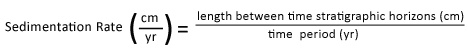 (1)
(1)
where:
cm = centimeters
yr = year
Using the three time-stratigraphic horizons above, sedimentation rates for each time period were determined by first assigning the 1963 horizon to the core section with the highest 137Cs activity. The 1963 time-stratigraphic horizon for any given section was assigned to the geometric middle of the sampled section. This introduces error by assuming that the activity found throughout the section is actually occurring in the middle of the section. Because it is not known precisely where in the section peak 137Cs activity occurs, an error for the sedimentation rate for a given time period was determined by assuming that the 1963 time-stratigraphic horizon could occur at either the top or the bottom of the section. Thus, along with the middle of the section, sedimentation rates were calculated using the top and bottom of the section and compared to the values determined for the middle of the section. This provided a range of sedimentation rates. For the period 1925-2008, the sedimentation rate was determined by dividing the entire length of the sediment core by 83 years - the amount of time Deep Creek Lake has existed. A separate horizon for the onset of 137Cs deposition between 1952-54 was not used as a time-stratigraphic horizon because mixing, desorption, and analytical resolution at the detection level commonly obscure the first occurrence of 137Cs (Peter Van Metre, U.S. Geological Survey, oral commun., January 14, 2009).
Results
Five cores had interpretable 137Cs signatures (table 2). A linear sedimentation rate in centimeters per year (cm/yr) was interpreted using the 137Cs data. Due to compaction of sediment in the deeper layers of the lake, some error may result in using a linear interpolation for sedimentation rates (Van Metre and others, 2004). The highest sedimentation rate, 1.83 cm/yr or 0.06 ft/yr (feet per year), occurred between 1925 and 1963 in core 23 (table 2). The lowest sedimentation rate occurred in core 21 between 1963 and 2008 (0.23 cm/yr or 0.008 ft/yr). Averaging sedimentation rates for all five cores by time-stratigraphic unit showed that the period 1925 to 1963 had the highest average sedimentation rate (1.26 cm/yr or 0.041 ft/yr), and the period 1963 to 2008 had the lowest average sedimentation rate (0.43 cm/yr or 0.014 ft/yr) (table 3). In general, sedimentation rates at any given site are variable with respect to time periods and are variable between sites. Although it is not uncommon for higher sedimentation rates to occur early after impoundment, further investigations into the climatic and land-use history of Deep Creek Lake would be necessary to understand the causes of temporal and spatial variations, in sedimentation rates (Callendar and Robbins, 1993).
Selected References
Blomqvist, S., 1985, Reliability of core sampling of soft bottom sediment an in situ study: Sedimentology, v. 32, no. 4, p. 605-612.
Davis, J.J., 1963, Cesium and its relationship to potassium in ecology, in Schultz, V., and Klement, A.W., Jr., eds., Radioecology: Washington, D.C., Reinhold Publication Corporation,., p. 539-56.
Perkins, R.W., and Thomas, C.W., 1980, Worldwide fallout, in Hanson, W.C., ed., Transuranic elements in the environment: Washington, D.C., Technical Information Center, U.S. Department of Energy,: DOE/TIC-22880, p. 53-82.
Van Metre, P.C., Wilson, J.T., Fuller, C.C., Callender, E., and Mahler, B.J., 2004, Collection, analysis, and age-dating of sediment cores from 56 U.S. lakes and reservoirs sampled by the U.S. Geological Survey, 1992-2001: U.S. Geological Survey Scientific Investigations Report 2004-5184, 120 p., available online at http://pubs.usgs.gov/sir/2004/5184/.
