
Water Use in the Deep Creek Lake Watershed, Garrett County, Maryland, 1980-2007
By Wendy S. McPherson
Introduction
The Deep Creek Lake watershed is in the Appalachian Plateau Physiographic Province in Garrett County, Maryland, and is a subwatershed of the Youghiogheny River watershed, which drains to the Mononghahela River. As the demand for freshwater increases in the watershed, stress is placed on local groundwater and surface-water resources. Availability of freshwater in the watershed depends on factors such as precipitation, geology, and topography. Water availability is also affected by changing population and development patterns that directly influence water use.
Water use within the Deep Creek Lake watershed can be separated into a number of general-use categories, including: public supply, domestic use, industrial, irrigation, and commercial. The U.S. Geological Survey (USGS) aggregates water-use data by each county in the Nation every 5 years; the most recent year is 2005. Additional data also are available for 2006 and 2007.
Methods
To assess water use in the Deep Creek Lake watershed, both permitted and non-permitted water users were considered. Most uses of water in Maryland require a Water Appropriation Permit (WAP) from the Maryland Department of the Environment (MDE). Permitted users with withdrawals exceeding 10,000 gallons per day (gal/d) are required to report monthly withdrawals to MDE. The USGS reviewed and quality-assured the reported monthly withdrawal data by county, and the data from 1980 through 2005 are stored in the USGS Site-Specific Water-Use Data System (SWUDS), a proprietary database. Water withdrawal data from 2006 and 2007 were also retrieved from MDEs database and are included in this report. In addition, permitted use was used as a surrogate of actual use for small users that would otherwise not have been required to report their water-use data.
Domestic water-use withdrawals from individual household wells do not require water-use permits. Records of well-construction permits were examined to estimate the number of individual domestic wells in the watershed. To determine an estimate of domestic water use, a usage coefficient was multiplied by the product of the estimated number of users per well and the number of permitted domestic wells in the Deep Creek Lake watershed.
Permitted Water Use in the Deep Creek Lake Watershed
In the Deep Creek Lake watershed, there were 211 facilities permitted in 2007 for a total of 95,845,180 gal/d. The locations of permitted water users with WAPs issued by MDE are shown in figure 1. The labels show the WAP number issued by MDE. The majority of water use occurs near the lake, with only minor permitted use occurring at greater distances from the lake.
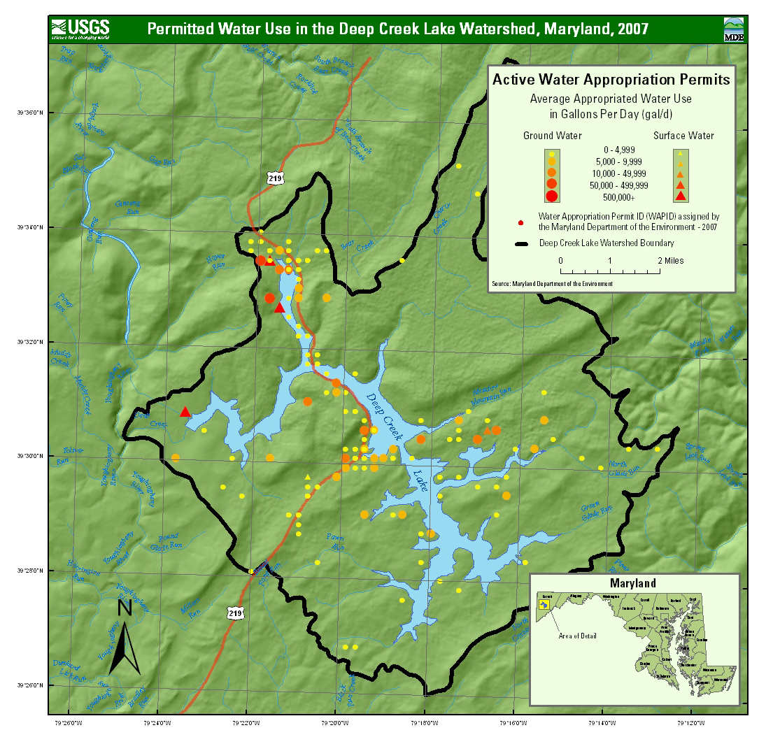
Figure 1. Permitted water use in the Deep Creek Lake watershed, 2007.
Click to view full-size.
Information for sites shown in figure 1 is summarized by water use category in table 1. USGS groups types of water-use into 10 categories. For each water-use category, the total and average permitted water use is shown in table 2, along with the minimum and maximum permit amounts for that category, and the number of facilities.
Table 1. Permitted (appropriated) water use in the Deep Creek Lake watershed, 2007.
Permitted water use in gallons per day for nine water-use categories is shown in figure 2. The single largest water-use category is hydroelectric, which is not shown in figure 2, because at 94,000,000 gal/d, it is several orders of magnitude larger than all other uses. The largest category of water use shown is for recreational purposes (643,000 gal/d). The next-highest category is irrigation, followed by subdivisions, and trailer parks.
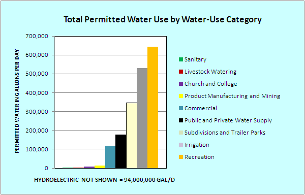
Figure 2. Total permitted water use in gallons per day by water-use category, Deep Creek Lake watershed, 2007.
The MDE permit database does not distinguish between consumptive and non-consumptive water use. Depending on the particular use, some of the withdrawn water is returned to the environment (non-consumptive use) through septic systems, discharges to surface water, or by other means. Some is removed from the watershed (consumptive use) through evapotranspiration, transport via the public sewer system, or by other means. Water used for hydroelectric generation is withdrawn from the lake and released to the Youghiogheny River. It could be considered consumptive use with respect to the lake watershed, and represents the primary route by which water leaves the watershed.
Reported Water Supply Withdrawals
Monthly withdrawals are reported to MDE for 10 groundwater appropriation permits and 4 surface-water WAPs in the Deep Creek Lake watershed, withdrawing more than 10,000 gal/d (table 3). The withdrawals are reported by permit number, although there may be multiple wells covered by a single permit.
Total reported average annual withdrawals under the 14 permits in the watershed were 75.6 Mgal/d in 2007. Excluding hydroelectric releases, water use under the other 13 permits totaled 1.09 Mgal/d. Annual withdrawals show an increasing trend over the period of record for the public supply wells. Water use for recreational facilities (largely snow-making) shows a slight increase over the period of record. Annual withdrawals for hydroelectric generation do not show an increasing trend; the amount of water used varies with annual precipitation over the watershed.
Monthly water withdrawals show variation with time of year. Withdrawals from public supply wells peak twice during the year, in February and August. Peak monthly use may reflect seasonal tourism peaks related to winter sports recreation and summer lake recreation. Withdrawals for the largest recreational user of water peak in January, corresponding to a period when snow-making is expected to peak. Monthly withdrawals for hydroelectric generation are largest from December through March; they are largest in March. The pattern of use over the course of the year likely reflects annual precipitation and run-off patterns.
The locations of the sites in the Deep Creek Lake watershed that report monthly withdrawals are shown in figure 3. The average annual values for these sites, in million gallons per day, are shown in table 3.
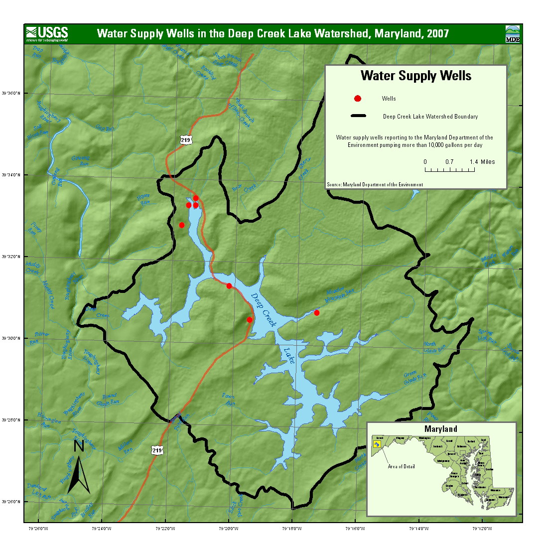
Figure 3. Water-supply well in the Deep Creek Lake Watershed, Maryland, 2007.
Click to view full-size.
Total withdrawals for public water-supply wells are shown in figure 4. Three permits for public supply wells were used in 1988. By 2007, withdrawals for public supply were made under six permits. The amount of water withdrawn has increased since 1988, presumably in response to population growth.
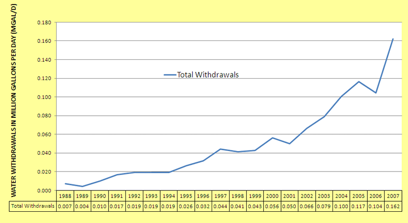
Figure 4. Total annual reported water withdrawals for water-supply wells in the Deep Creek Lake watershed, 1988-2007.
Domestic Water Use from Individual Wells
There were approximately 2,900 wells permitted by MDE in the Deep Creek Lake watershed from 1969 to 2007. Most of the wells (2,720) were domestic or residential wells, 96 were commercial/industrial wells, and 7 were irrigation/farm wells.
The total domestic water use in the Deep Creek Lake watershed (based on 2,720 domestic wells) is estimated to be between 435,200 gal/d (0.43 Mgal/d) and 870,400 gal/d (0.87 Mgal/d). Half (1,390) of the domestic wells are within 1,000 feet of the lake. The Town of McHenry and the WISP resort area are served by public water supplies.
Summary
Water withdrawals have increased with demand from the growing population and water-related activities in the Deep Creek Lake watershed. The water-use category with the largest increase in withdrawals since 1988 is public water supply. Water use for public supply varies seasonally, with peaks during the winter and summer reflecting the seasonality of recreational activities.
Future work might include refining the estimate of domestic water usage by using tax-map information to identify the number of homes with wells. In addition, metered data could be used to provide improved estimates of seasonal water usage.
