
Monitoring of Transient Groundwater Conditions at Deep Creek Lake, Garrett County, Maryland, 2007
By Daniel J. Soeder
Introduction
The potential degree of connection between groundwater levels and lake levels at Deep Creek Lake was investigated during seasonal lake drawdown in fall 2007. Maintenance by the Maryland Department of Environment (MDDNR) at the dam intakes required the lake levels to be drawn down lower than normal during this period, providing an opportunity to observe the possible effects of low lake levels on nearby groundwater levels. Water levels were measured in a number of wells periodically or continuously over several months during drawdown to investigate whether the lake is hydraulically connected to the groundwater system. The goals of this investigation were to improve the understanding of hydraulic connectivity between the lake and the groundwater system, obtain information for future estimations of the water budget in the Deep Creek watershed, and provide insight into the possible effects of groundwater withdrawals on the groundwater supply to the lake.
Hydrogeologic Background
Deep Creek Lake in Garrett County, Maryland lies within the Appalachian Plateau Physiographic Province (Edwards, 1981). The primary geologic structures in the county consist of Paleozoic sedimentary rocks gently folded into a number of broad anticlines and synclines that trend from the northeast to the southwest. The topographic ridges are formed as a result of erosion-resistant rock materials exposed on the flanks of the folds, whereas valleys are formed where softer rocks have been eroded.
Anticlinal and synclinal structures in the area are underlain by Devonian sedimentary rocks and are frequently mined for natural gas (anticlines) and coal (synclines) (Nutter and others, 1980). Deep Creek Lake lies across the Deer Park anticline, and extends to the southern end of the Accident anticline. The Accident anticline has been used for natural gas storage (Amsden, 1953).
The oldest rocks that crop out in Garrett County are Middle to Late Devonian-age shales, siltstones, sandy shales, and thin-bedded sandstones of the Hamilton Group and the Jennings and Hampshire Formations (Amsden, 1953). The Hamilton Group contains the Marcellus Shale, which is currently (2010) of interest for natural gas production. The Jennings and Hampshire Formations are important aquifers in the Deer Park anticline area in the eastern part of Garrett County (Nutter and others, 1980).
The Devonian rocks are overlain by the Mississippian-age Pocono Sandstone, Greenbrier Limestone, and Mauch Chunk Formation (Amsden, 1953). The Pocono Sandstone is an important aquifer in the Deer Park and Accident anticlines, with many springs and wells, including some high-yield wells (Nutter and others, 1980). The Greenbrier and Mauch Chunk Formations are less important sources of groundwater.
The youngest consolidated rocks in Garrett County consist of Pennsylvanian-age coal-bearing units, including the Pottsville Formation, Allegheny Formation, Conemaugh Formation, and Monongahela Formation. The Pottsville and Allegheny Formations were mapped as a single unit in Garrett County by Amsden (1953). These sand-rich units are considered moderately important to important aquifers along the flanks of coal basins (Nutter and others, 1980). The base of the Conemaugh Formation is defined by the Upper Freeport Coal, and the top is marked by the Pittsburgh Coal (Amsden, 1953). The Conemaugh Formation is near the top of the stratigraphic section, has a thickness of 800 to nearly 1,000 ft (feet), a mean yield of 13 gal/min (gallons per minute), is a very important aquifer within the coal basins of Garrett County, and contains numerous wells (Nutter and others, 1980). The Monongahela Formation is only present in small areas on ridgetops in Garrett County, and is not considered an important aquifer. Unconsolidated, Quaternary-age deposits on top of the bedrock such as alluvium and peat are not used as aquifers because of their limited areal extent and thickness.
Methods
The project was completed in two distinct phases. The first phase involved the search of state and county records to identify wells for water-level monitoring. The second phase investigated groundwater interactions with the lake. A survey of well records and water-appropriation records was conducted for the entire Deep Creek Lake watershed, with emphasis on wells within 1,000 ft of the lake shoreline. A summary database of approximately 12,320 well completion reports was obtained from the Maryland Department of the Environment for all of Garrett County. This list was then sorted by "nearest town" and subdivision name to eliminate wells not in the vicinity of Deep Creek Lake. This left approximately 4,763 wells in the lake area. These remaining wells were sorted by latitude and longitude to produce a list of over 3,800 candidate wells within about 1,000 ft of the lake shore. Data on the wells were available through the completion reports submitted by drillers as part of the well-permitting process. The reliability of information in these reports varied considerably. Location data, especially latitude and longitude, were often incorrect or inaccurate. This was discovered when location data obtained from the completion reports were plotted on digital maps. Many wells plotted in the same location, in water bodies, or outside the jurisdiction in which they were reported to have been drilled. Construction data, including depth to the bottom of the cased interval, the open interval, and aquifer information, were often inconsistent or incomplete. In order to resolve the problems associated with using completion reports as a screening tool for well selection, a county employee familiar with the area and development history was consulted on September 9, 2007 (Allen Festerman, Operations Manager of the Garrett County Department of Public Utilities). To select a final group of wells for monitoring, a USGS hydrologist visited a number of well sites with Mr. Festerman, and four candidate wells were selected for instrumentation to monitor possible groundwater-level drops related to lowering of the lake level. These sites were the Willows well (GA Cb 81), the Deep Creek Village well (GA Cb 80), the Thousand Acres well (GA Dc 140), and the Carmel Cove well (GA Cc 66). The locations of the wells are shown in figure 1.
Wells GA Cb 80, GA Cb 81, and GA Cc 66 were auxiliary municipal water-supply wells containing wiring and pumps, but they were not regularly pumped. Well GA Dc 140, located at a development known as Thousand Acres, was a test well at a new construction site, and did not contain any down-hole equipment. Wells GA Cb 80, GA Cc 66, and GA Dc 140 were instrumented with pressure transducers on October 2, 2007. The pump in well GA Cb 81 at The Willows blocked the installation of a transducer. Instrumentation of this well was delayed until November 21, 2007, after a smaller pressure transducer was installed below the pump. The instruments were removed from all four wells on December 14, 2007. Hydrologic technicians from the USGS visited prospective sites for additional periodic water-level measurements to be made with an electric tape. Information on the sites was obtained from completion reports or other sources, and permission was obtained from the land owners to access the nine wells that were selected. The locations of these wells, primarily domestic supply wells for lake cottages and vacation homes, are also shown in figure 1. Periodic measurements of water levels in these wells were made between October 1, 2007 and December 14, 2007.
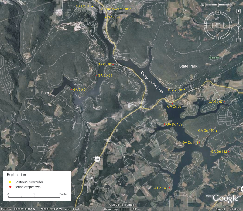
Figure 1. Location of instrumented wells, periodically measured wells, and lake-level monitor at Deep Creek Lake in Garrett County, Maryland, October to December 2007.
Lake-level data were collected by Brookfield Power Company, which is located at the dam (fig. 1). Hourly pool elevations collected at the spillway were made available to the USGS by the Brookfield Power Company, the operator of the dam, and the Deep Creek Hydroelectric Power Plant (http://www.deepcreekhydro.com/default.html). The dam data provided lake levels through the drawdown period, including the low stand of the lake on October 22-23, 2007. Brookfield Power Company supplied data through the end of calendar year 2007. These data showed a gradual recovery of the lake level through November, with a sharper rebound in early December that peaked and flattened out about mid-month. The lake-level data from October 1 through December 31, 2007 are shown in figure 2. Lake levels from the Brookfield Power Company spillway measurements are used in this report and are referenced to ft above the National Geodetic Vertical Datum of 1929 (NGVD 1929) (Brookfield Power Company, oral commun., 2007).
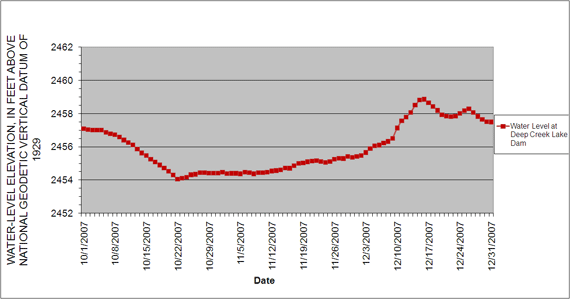
Figure 2. The decline and recovery of the water levels at Deep Creek Lake Dam, Garrett County, Maryland, October through December 2007.
Results
The effects of precipitation and potential recharge on the continuously monitored wells were determined by obtaining National Oceanic and Atmospheric Administration (NOAA) climate and precipitation data for Garrett County during the period of interest (available online at http://www.ncdc.noaa.gov/oa/ncdc.html, accessed November 30, 2009). These data were collected at Oakland, Maryland, to the southeast of Deep Creek Lake, and at Savage River Dam, southwest of Deep Creek Lake. The data at these sites did not include intensity, duration, or extent of precipitation and did not indicate whether it was localized or widespread. Thus, it was not possible to determine if precipitation at either station occurred in the Deep Creek area, nor was it possible to determine (exclusively through the precipitation record) if a specific precipitation impacted groundwater levels at Deep Creek Lake. An average of precipitation from both sites was used in the current study and is shown as daily values in figure 3.
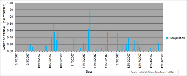
Figure 3. Precipitation data from Garrett County, Maryland during the drawdown of Deep Creek Lake, October through December 2007.
Daily values of Deep Creek Lake levels and water-level data from the four instrumented wells near the lake are shown in table 1. The values in the table are given as water-level elevations above NGVD29. The Willows well (GA Cb 81) was the closest to the lake shore of the four wells instrumented, and the Thousand Acres well (GA Dc 140) was the farthest away. The delay in the start date for collection of water-level data from well GA Cb 81 was caused by the need to obtain a special, smaller pressure transducer that could fit past the pump obstructing access to this well.
Table 1. Daily values for lake level and groundwater wells with continuous data recorders, Deep Creek Lake, Garrett County, Maryland, 2007.
Click to view table
However, the few weeks of recorded data that were obtained show that groundwater levels in this well were slightly higher than and closely tracked water levels in Deep Creek Lake (fig. 4). Well GA Cb 81 is relatively shallow (sounded to 75 ft below land surface), and the aquifer at this location may be in direct hydraulic connection with the lake.
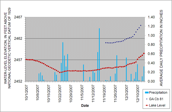
Figure 4. Water levels measured in the Willows well (GA Cb 81) compared to lake levels and precipitation, Garrett County, Maryland, October to December 2007.
Two of the other instrumented wells showed water-level responses that appear to be related to changes in lake levels. Water levels in the well at Deep Creek Village (GA Cb 80), shown in figure 5, exhibit a decline during the period of lake-level decline, a change in slope when the lake reached the late October low-stand, and then a climb in December when the lake began rising rapidly. The well also showed a response to the precipitation events in late October, mid- and late November, and early and mid-December. In addition, well GA Cb 80 showed changes in water levels that do not appear to have been caused by changes in lake level or precipitation. Nonetheless, there appears to be some hydraulic connection between groundwater at this location and the lake.
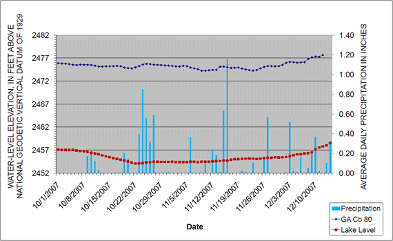
Figure 5. Water levels measured in the Deep Creek Village well (GA Cb 80) compared to lake level and precipitation, Garrett County, Maryland, October to December 2007.
Water levels in well GA Dc 140 at Thousand Acres, the instrumented well farthest from the lake shore, also showed patterns that may be related to changes in lake levels. As shown in figure 6, this well experienced a decline in October that paralleled declining lake levels. At an elevation of about 2,456 ft, well GA Dc 140 appears to stabilize to a potentiometric level not related to lake level. However, between the second week in October until monitoring was discontinued in late December, the dominant influence on water levels in well GA Dc 140 appeared to be several precipitation events, especially the large events of October and November. As lake level rose, however, the overall trend in the water level in well GA Dc 140 also rose. The inflection point, where the slope changes from falling to rising, corresponds within a couple days for both the well and the lake level. The apparent response of the groundwater level in well GA Dc 140 to changes in lake levels is noteworthy because this well is about 400 ft deep and is distant from the lake shore (approximately 1,500 ft) (fig. 6).
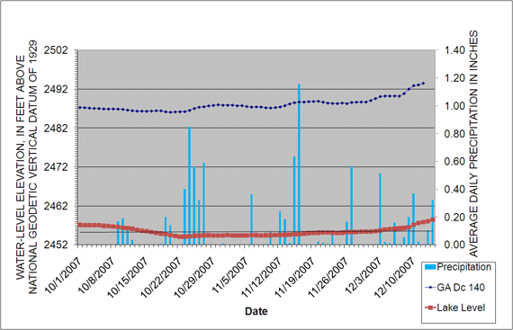
Figure 6. Water levels measured in the Thousand Acres well (GA Dc 140) compared to lake levels and precipitation, Garrett County, Maryland, October to December 2007.
The final instrumented well, GA Cc 66 at Carmel Cove, showed multiple, short-term episodes of drawdown and recovery that are characteristic of a well affected by a nearby pumping well (fig. 7). In addition, the water level in the well seems to have been affected by the precipitation event in mid-November. The periodic low of 2,465.3 ft is a manifestation of the placement of the measurement equipment in the well. Specifically, the device used to measure the water level in the well was set at an elevation above the maximum elevation of drawdown. Each time water levels in the well dropped below the device, an elevation of 2,465.3 ft was recorded. Possible effects on the groundwater level from the low-stand of the lake were obscured by these short-term water-level fluctuations. Undisturbed water levels in the Carmel Cove well did show a steady rise from late October to the end of the record, consistent with the steady rise of the lake surface. Such a rise could also be indicative of groundwater level recovery following cessation of an earlier withdrawal event, however, making it difficult to draw any conclusions about the connectivity of this well to the lake.
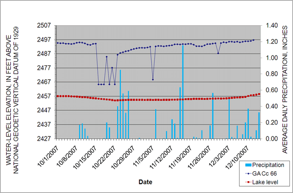
Figure
7. Water levels measured in the Carmel Cove well (GA Cc 66) compared to lake levels and precipitation, Garrett County, Maryland, October to December 2007.
Nine additional wells were measured periodically throughout the study period. To determine the relative effect of lake level on these wells, water-level-elevation data were plotted as a relative increase or decrease with respect to initial elevation. Lake levels also were plotted in a similar manner (fig. 8). Water levels in wells GA Dc 139, GA Cc 67, and GA Cb 82 closely paralleled relative lake-level elevations without showing the effects of precipitation. Water levels in wells GA Cc 88, GA Dc 141, GA Dc 143, and GA Cb 84 showed trends reflecting the general decline and rise of lake levels over the monitoring period. Water levels in wells GA Cc 88 and GA Dc 143 showed a steep rise in early November and a decline in mid-November, respectively; these patterns may or may not be related to the effects of precipitation or pumping. Wells GA Cb 83 and GA Dc 142 appeared to be least affected by lakelevel changes. Water levels in well GA Cb 83 continued to decline in October after Deep Creek Lake reached its lowest level, and then rose markedly after a 5-day precipitation event in late October. The well also showed the effects of a precipitation event in midNovember. Generally, the well seemed to respond to an overall seasonal rise that showed responses to large precipitation events and possibly to nearby pumping. Water levels in well GA Dc 142 exhibited very little response that could be related to lake-level changes or precipitation, indicating that the well may have little or no hydraulic connection to the lake as a result of the local geology or some other factor. The manual water-level measurements collected from the nine observation wells are listed in table 2.
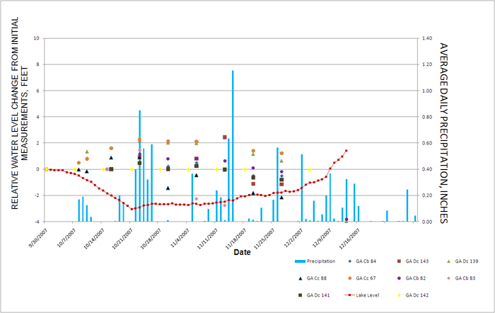
Figure
8. Manual water-level measurements in wells near Deep Creek, Garrett County, Maryland, October to December 2007.
Table 2. Manual, periodic tape-down measurements of water levels in wells at Deep Creek Lake, Garrett County, Maryland, October to December 2007
Click to view table.
Summary and Conclusions
Measurements of groundwater levels in 13 wells near Deep Creek Lake, Garrett County, Maryland, during an episode of greater-than-normal lake drawdown in fall 2007 indicated that at least some of the wells have a hydraulic connection to the lake. Many of these wells are used for domestic water supply. Water levels in wells GA Cb 81, GA Cc 68, and GA Cb 83 showed a strong response between groundwater levels and lake levels. Other wells showed more subtle responses, and several wells showed little or no response at all.
Proximity to the lake does not appear to be the only factor affecting the relation between lake levels and groundwater levels in any particular observation well. The degree of hydraulic connection between the lake and the aquifer is not only a function of proximity to the lake. Well GA Dc 140 at Thousand Acres, located over a quarter of a mile from the lake shore, for example, showed changes in groundwater levels that appeared to be related in timing and trend to lake-level changes. Conversely, well GA Dc 142, located less than 200 ft from the lake shore, showed total water-level fluctuations of only 0.04 ft. A more complex pattern of fractures in the rock, rock type, topography, and other factors may control the degree of hydraulic connection.
Improved well-construction information; more accurate data for total depth, bottom of casing, open or finished intervals; and the results of pumping tests could help to better characterize the factors relating groundwater levels in wells to lake levels. A better understanding of the geology of the Deep Creek Lake area, including stratigraphy, aquifer properties, and geologic structure, would also be helpful in assessing potential hydraulic connections between groundwater and the lake.
References Cited
Amsden, T.W., 1953, Geologic map of Garrett County: Baltimore, Maryland, Maryland Geological Survey, single sheet.
Edwards, J., 1981, A brief description of the geology of Maryland: Maryland Geological Survey, pamphlet series, 1 p.
Nutter, L.J., Smigaj, M.J., and Knobel, L.L., 1980, Garrett County water-well records, chemical quality data, ground-water use, coal test-hole data and surface-water data: Maryland Geological Survey Basic Data Report No. 11, 102 p.
