U.S. Geological Survey Open-File Report 2010-1146
Coastal Vulnerability Assessment of the Northern Gulf of Mexico to Sea-Level Rise and Coastal Change
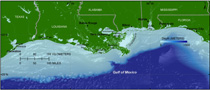
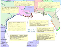
The Northern Gulf of Mexico coastline as defined in this study stretches from Galveston, TX, to east of Panama City, FL, spanning approximately 1,200 km of the Gulf of Mexico, not including inland bays (fig. 2). The length of coastline, including coastal bays, totals just less than 11,000 km, based on the GSHHS (global self-consistent, hierarchical, high-resolution shoreline) database (Wessel and Smith, 1996). The Gulf of Mexico can be divided into morphologic reaches based on wave energy, geology, and lithology (fig. 3). Four of the eight morphologic reaches defined by A. Morang (written communication, January 11, 2010) fall within the Northern Gulf of Mexico CVI study area and are described here. The easternmost morphologic reach stretches from Apalachicola, FL, west through the Mississippi barrier islands, and can be described as relatively sand rich, with numerous barrier islands, and a dominant east to west alongshore transport (fig. 3; G5). Moving westward, the adjacent morphologic reach extends from the end of reach 1 (Pass Christian, MS) to Southwest Pass, LA (fig. 3; G6). This area can be described as being dominated by muddy deltaic sediments delivered by the Mississippi River. Compaction and subsidence of these sediments combined with an inconsistent supply of sediment, due to river avulsion and channelization, have contributed to severe erosion and wetland loss in this area. The third reach covers the Chenier Plain of western Louisiana and eastern Texas to High Island, TX (fig. 3; G7). The Chenier Plain is a marginal-deltaic environment characterized by a muddy substrate with interspersed sand and shell ridges. The last 40 km of the CVI shoreline defined in this study, lie on the Bolivar Peninsula just north of Galveston, TX (fig. 3; G8). This stretch of coast is dominated by sandy barrier islands enclosing shallow bays. |

![]() U.S. Department of the Interior |
U.S. Geological Survey
U.S. Department of the Interior |
U.S. Geological Survey
URL: https://pubsdata.usgs.gov/pubs/of/2010/1146/html/setting.html
Page Contact Information: Contact USGS
Page Last Modified: Wednesday, 07-Dec-2016 22:36:48 EST