U.S. Geological Survey Open-File Report 2010-1146
Coastal Vulnerability Assessment of the Northern Gulf of Mexico to Sea-Level Rise and Coastal Change
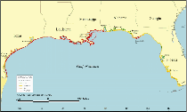
As part of the Northern Gulf of Mexico (NGOM) Ecosystem Change and Hazard Susceptibility project, the U.S. Geological Survey (USGS) conducted a coastal vulnerability assessment of the impacts of future sea-level change to this coast. This report presents the results of a vulnerability assessment for the Northern Gulf of Mexico from Galveston, TX, to Panama City, FL, and highlights areas that are likely to be most affected by future sea-level rise. Published analyses of tide gauge data suggest a 20th century mean rate of global sea-level rise (SLR) to be 1.7 mm/yr (Bindoff and others 2007). Climate modelers predict a future global rise in sea level of 0.25 - 0.5 m by 2100, which for several carbon emission scenarios is more than double the rate of rise for the 20th century (Meehl and others, 2007). Global SLR estimates from satellite altimeter missions suggest a mean rate of rise of 3 mm/yr since 1993 (Milne and others, 2009), and these rates resemble predicted SLR acceleration estimates for the 21st century published by the IPCC (Meehl and others., 2007). The exact rates of present and future global SLR are uncertain; however, the potential coastal impacts of global SLR include shoreline erosion, storm-surge flooding, saltwater intrusion into groundwater aquifers, inundation of wetlands and estuaries, and threats to cultural and historic resources as well as infrastructure (Nicholls and others, 2007). Expected accelerated global sea-level rise and the response of the coastline have become an area of active research. Although a quantitative tool that accurately predicts coastal response to sea-level rise has not yet been perfected due to the complexity of coastal systems, there are many valuable tools that can be utilized including simple inundation models, probabilistic frameworks, and coastal vulnerability assessments. Coastal vulnerability index (CVI) assessments have been used for over a decade to identify areas that may be most vulnerable to impacts of future sea-level rise, and to provide maps and data to support coastal management decisions (Gornitz and others, 1994; Shaw and others, 1998; Hammar-Klose and Thieler, 2001; Pendleton and others, 2010). The CVI combines the coastal system's susceptibility to change with its natural ability to adapt to changing environmental conditions, yielding a quantitative, although relative, measure of the shoreline's natural vulnerability to the effects of sea-level rise. The methodology focuses on six variables which strongly influence coastal response to sea-level rise: 1) Geomorphology 2) Historical shoreline change rate 3) Regional coastal slope 4) Relative sea-level change 5) Mean significant wave height 6) Mean tidal range The geologic variables, including geomorphology, historic shoreline change rate, and coastal slope, account for a shoreline's relative resistance to erosion, long-term erosion/accretion trend, and susceptibility to flooding, respectively. The physical process variables, including sea-level change, mean significant wave height, and tidal range, all contribute to the inundation hazards of a particular section of coastline over time scales from hours to centuries. In order to apply this CVI, it is assumed that these six variables are the primary factors responsible for long-term (tens to hundreds of years) coastal change. An obvious omission to long-term coastal change is storms, which are difficult to define as a variable due to their episodic and local nature. CVI results presented in this report are an indication of vulnerability based on coastal processes and geologic qualities that are ever present and predictable. A relatively simple vulnerability ranking system allows these six variables to be incorporated into an equation that produces a coastal vulnerability index . The CVI can be used by scientists and managers to evaluate the likelihood that physical change may occur along a particular shoreline as sea level continues to rise. The study presented here builds on an earlier CVI assessment that was calculated for the Gulf of Mexico at 3-minute resolution (Thieler and Hammar-Klose, 2000b) (fig. 1). Recent updates to shoreline change datasets and wetland loss observations as well as subsidence and elevations data increase the resolution of the input data and result in an improved CVI assessment. Here we focus on the Northern Gulf of Mexico from Panama City, FL, to Galveston, TX. This portion of the Gulf of Mexico encompasses some of the most fragile coastal and wetland systems in the United States. Intense storms and high rates of relative sea-level rise, especially along coastal Louisiana, make this region, its infrastructure, ecosystems, and natural resources a primary concern for coastal managers. |

![]() U.S. Department of the Interior |
U.S. Geological Survey
U.S. Department of the Interior |
U.S. Geological Survey
URL: https://pubsdata.usgs.gov/pubs/of/2010/1146/html/intro.html
Page Contact Information: Contact USGS
Page Last Modified: Wednesday, 07-Dec-2016 22:36:44 EST