U.S. Geological Survey Open-File Report 2011-1040
Continuous Resistivity Profiling Data From Great South Bay, Long Island, New York
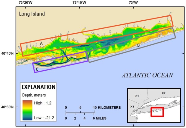 |
| Figure 8. Map showing submarine groundwater discharge (SGD) environments in Great South Bay, Long Island, New York. These SGD environments can be divided into three primary types. The north shore of the bay (box A) is dominated by filled and natural marsh deposits, with adjacent submerged peats and clays that commonly promote flow of low-salinity groundwater to distances of greater than 100 meters (m) offshore. The south central and southeastern shores of the bay (north shore of Fire Island; box B) consist of modern marshes and drowned peats on shallow, sandy overwash fans that result in similarly wide SGD zones. The young, sandy spit that makes up the western end of Fire Island (box C) does not have extensive submarine confining units and therefore has narrow SGD zones less than 10 m wide. The bathymetric data were acquired from the National Oceanic and Atmospheric Administration estuarine bathymetry Web site (accessed April, 2008 at http://estuarinebathymetry.noaa.gov/). |

![]() U.S. Department of the Interior |
U.S. Geological Survey
U.S. Department of the Interior |
U.S. Geological Survey
URL: http://pubsdata.usgs.gov/pubs/of/2011/1040/html/figurepages/fig8.html
Page Contact Information: GS Pubs Web Contact
Page Last Modified: Thursday, 08-Dec-2016 00:30:19 EST
