U.S. Geological Survey Open-File Report 2012–1004
Sea-Floor Geology in Central Rhode Island Sound South of Sakonnet Point, Rhode Island
![]() Title |
List of Figures |
Conversion Factors |
Abstract |
Introduction |
Setting |
Methods |
Bathymetry |
Sediments |
Bottom Photography |
GIS Data Catalog |
Summary |
Acknowledgments |
References |
Contacts
Title |
List of Figures |
Conversion Factors |
Abstract |
Introduction |
Setting |
Methods |
Bathymetry |
Sediments |
Bottom Photography |
GIS Data Catalog |
Summary |
Acknowledgments |
References |
Contacts
 |
||
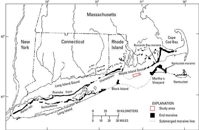
Figure 2. Map of end moraines (black polygons) and submerged ridges (dashed lines) in southern New York and New England (modified from Gustavson and Boothroyd, 1987) with study-area location (red polygon). The Ronkonkoma-Block Island-Nantucket end moraine represents the maximum advance of the Laurentide Ice Sheet about 20,000 to 24,000 years ago, while the Harbor Hill-Roanoke Point-Charlestown-Buzzards Bay end moraine, of which a submerged segment crosses through the study area, represents a retreated ice-sheet position from about 18,000 years ago (Uchupi and others, 2001). |
||


