Open-File Report 2014–1012
![]() Title |
List of Figures |
Conversion Factors |
Abstract |
Introduction |
Methods |
Bathymetry |
GIS Data Catalog |
Summary |
Acknowledgments |
References |
Contacts
|
Index
Title |
List of Figures |
Conversion Factors |
Abstract |
Introduction |
Methods |
Bathymetry |
GIS Data Catalog |
Summary |
Acknowledgments |
References |
Contacts
|
Index
 |
||
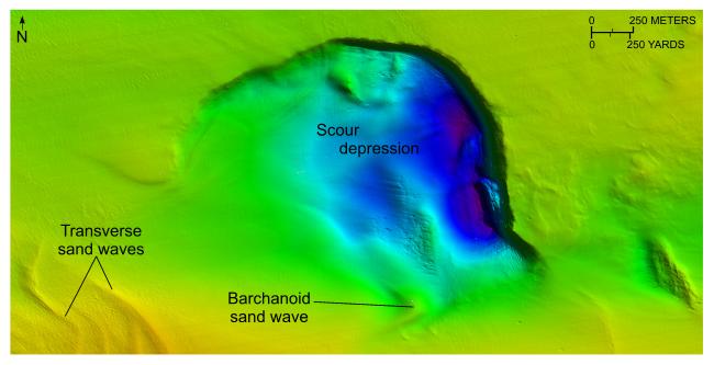
Figure 14. Detailed planar view of the sun-illuminated bathymetry from the combined National Oceanic and Atmospheric Administration surveys in Rhode Island and Block Island Sounds showing a deep isolated scour depression in a channel south of the eastern end of Fishers Island. The depression is more than 101 m deep and has been eroded into glaciolacustrine sediments underlying this part of Block Island Sound. Location of view is shown in figure 11. Warmer colors denote shallower areas; cooler colors denote deeper areas. Depth key is shown in figure 9. |
||

![]() U.S. Department of the Interior |
U.S. Geological Survey
U.S. Department of the Interior |
U.S. Geological Survey
URL: http://pubsdata.usgs.gov/pubs/of/2014/1012/html/fig14.html
Page Contact Information: GS Pubs Web Contact
Page Last Modified: Wednesday, 07-Dec-2016 19:33:17 EST
