Open-File Report 2014-1012
![]() Title |
List of Figures |
Conversion Factors |
Abstract |
Introduction |
Methods |
Bathymetry |
GIS Data Catalog |
Summary |
Acknowledgments |
References |
Contacts
|
Index
Title |
List of Figures |
Conversion Factors |
Abstract |
Introduction |
Methods |
Bathymetry |
GIS Data Catalog |
Summary |
Acknowledgments |
References |
Contacts
|
Index
 |
||
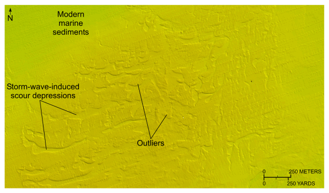
Figure 19. Detailed planar view of the sun-illuminated bathymetry from the combined National Oceanic and Atmospheric Administration surveys in Rhode Island and Block Island Sounds showing storm-wave-induced scour depressions on an isolated bathymetric high in southwestern Rhode Island Sound. Note the presence of outliers of modern marine sediments. Location of view is shown in figure 11. Warmer colors denote shallower areas; cooler colors denote deeper areas. Depth key is shown in figure 9. |
||

![]() U.S. Department of the Interior |
U.S. Geological Survey
U.S. Department of the Interior |
U.S. Geological Survey
URL: http://pubsdata.usgs.gov/pubs/of/2014/1012/html/fig19.html
Page Contact Information: GS Pubs Web Contact
Page Last Modified: Wednesday, 07-Dec-2016 19:33:19 EST
