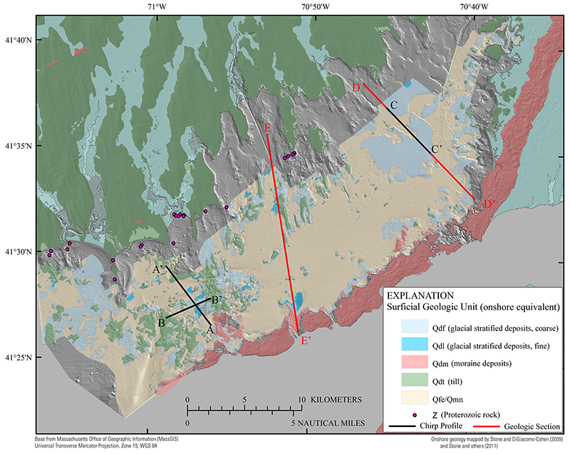
Figure 16. Map showing the surficial geology of Buzzards Bay with equivalent onshore glacial surficial geology (adapted from Stone and DiGiacomo-Cohen, 2009; Stone and others, 2011). The areal extents over which offshore subsurface geologic units crop out at the sea floor were interpreted from seismic-reflection data. See figure 9 for detailed descriptions of the offshore geologic units. Holocene sediment veneers too thin to be detected in the seismic-reflection data (less than approximately 0.5 m) might overlie outcrops of Pleistocene units locally. The bathymetry hillshade relief map is modified from the composite bathymetry of Buzzards Bay (fig. 3). Chirp profile locations are shown with black lines. Qmn/Qfe, undifferentiated Holocene nearshore marine and Holocene fluvial and estuarine; Qdt, undifferentiated Pleistocene glacial till and ice contact; Qdm, Pleistocene glacial moraine (Buzzards Bay moraine); Qdf, Pleistocene glaciofluvial (outwash and glaciodeltaic); Qdl, Pleistocene glaciolacustrine deposits (glaciodeltaic and lake floor).
|