Open-File Report 2014-1224
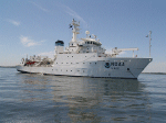
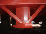
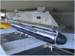
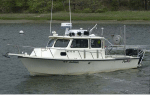
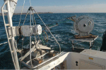
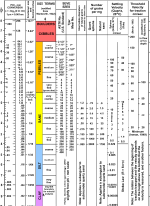
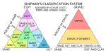
MethodsMBES and sidescan-sonar data were collected between August and November 2011 on the NOAA ship Thomas Jefferson (fig. 3) and two of its survey launches, 3101 and 3102 (fig. 4), during hydrographic survey H12298. RESON SeaBat 7125 systems (400 kilohertz [kHz]; fig. 5) were used aboard all three vessels to collect MBES data. Klein 5000 sidescan-sonar systems (455 kHz; fig. 6) were used aboard the survey launches to collect sidescan-sonar data in the study area near the shore. Water depths are referenced to mean lower low water level and have been corrected for tides by using National Water Level Observation Network stations in Newport, Rhode Island; New London, Connecticut; and Montauk, N.Y. Horizontal positioning was determined by using differential global positioning system (DGPS) equipment that used corrections from DGPS stations in Sandy Hook, New Jersey, and Moriches, N.Y. MBES data were acquired with Hypack software and converted to Computer Aided Resource Information System (CARIS) data format. Field Sheets processed by NOAA in CARIS were read back into CARIS by the USGS and exported as an Esri American Standard Code for Information Interchange (ASCII) raster grid and a color, hill-shaded Geospatial Tagged Image File Format (GeoTIFF). The 2-meter (m) grid was converted to an Esri binary grid in ArcGIS. Sidescan-sonar data were acquired with Klein SonarPro software and converted to CARIS data format. CARIS SIPS software was used to correct the slant range and beam pattern and create a mosaic of the sidescan-sonar data with 1-m resolution. More detailed information on the data acquisition and processing of MBES and sidescan-sonar data can be found in the metadata files in the Geographic Information System Data Catalog section of this report and in the data acquisition and processing and descriptive reports (National Oceanic and Atmospheric Administration 2011a, b). Sediment samples, bottom video, and still photographs of the sea floor were collected by the USGS during cruise 2013-005-FA from June 17 to 20, 2013, aboard the research vessel (RV) Rafael (fig. 7). The small Seabed Observation and Sampling System (SEABOSS), a modified Van Veen grab sampler with attached video and still cameras, was used to take samples and collect photography (fig. 8). At each station the SEABOSS drifted over the sea floor for several minutes, collecting bottom video along the transect while the operator took still photographs. Generally, a sediment sample would be obtained at the end of the station transect unless the sediment on the sea floor was too coarse or sea-surface conditions were too rough for sample collection. Sediment samples taken from the top 2 centimeters (cm) of the sea floor were analyzed for grain size at the USGS Woods Hole Coastal and Marine Science Center’s Sediment Lab following the methods of Poppe and others (2005). Coarse fractions (sand and gravel; diameters equal to or greater than 0.0625 millimeters [mm]) of the samples were analyzed with sieves; fine fractions (silt and clay; diameters less than 0.0625 mm) were analyzed with a Beckman Coulter Multisizer 3. Gravel-sized shells were removed from the samples because they form in situ, are generally not considered to be reflective of the sedimentary environment, and do not hydraulically behave in the same manner as similarly sized sediment. Sediment descriptions are based on the modified nomenclature of Wentworth (1922; fig. 9) and modified size classification of Shepard (1954; fig. 10). At each station, 1 to 8 photographs of the sea floor were taken at the discretion of the operator. Photographs were taken with a Canon PowerShot G12 from an ideal height of about 60 cm above the sea floor, which resulted in images showing 30-cm to 1-m widths of the sea floor. Images of the still photographs can be seen in the Bottom Photography section of this report and mid- and full-resolution photographs and location data are available in the Geographic Information System Data Catalog section of this report. Bottom video can be obtained from the Data Library at the USGS Woods Hole Coastal and Marine Science Center, Woods Hole, Massachusetts. Interpretations in this report are based on MBES, sidescan-sonar, sediment, and photographic data. Bedforms are characterized by their morphology and height; sand waves are higher than 1 m, megaripples are 0.2 to 1 m high, and ripples are less than 0.2 m (Ashley, 1990). |

![]() U.S. Department of the Interior |
U.S. Geological Survey
U.S. Department of the Interior |
U.S. Geological Survey
URL: http://pubsdata.usgs.gov/pubs/of/2014/1224/html/ofr2014-1224-methods.html
Page Contact Information: GS Pubs Web Contact
Page Last Modified: Wednesday, 07-Dec-2016 20:07:00 EST