Open-File Report 2014-1224
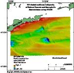
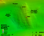
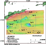
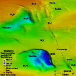
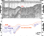
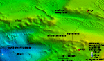
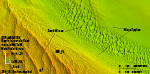
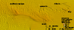
BathymetryWater depths in the study area range from 1 m just offshore of Fishers Island to 102 m in a bathymetric depression in the center of the study area (fig. 11). A small shelf borders the southern coast of Fishers Island, where water depths are shallower than 30 m for a distance of about 2 kilometers (km) away from the island. Further offshore, water depths increase to about 40 to 50 m in a couple of east-west-oriented channels. Several isolated bathymetric highs are throughout the study area, and within the channels are three isolated bathymetric depressions. Bedforms and trawl marks are also seen in the bathymetric data. Bathymetric HighsThe surface of an isolated bathymetric high in the northwest has numerous, low ridges oriented north-northwest to south-southeast that are clearly visible in the bathymetric data (figs. 12 and 13). These ridges roughly parallel similarly oriented ridges, grooves, and striations described on the bedrock of southwest Rhode Island (Schafer, 1965), southeast Connecticut (Goldsmith, 1962), and offshore of southeast Connecticut (Poppe and others, 2006, 2007). Rocky, elongate bathymetric highs south of the eastern end of Fishers Island are oriented in a north-northwest to south-southeast direction, roughly parallel to the Laurentide Ice Sheet’s flow direction in this area and the ridges on the bathymetric high in the northwest (fig. 14). Individual bathymetric highs have lengths of about 500 m to 1 km, widths of about 200 m, and heights of several meters. A seismic line over one of these features shows unstratified, acoustically opaque sediment (fig. 15; Needell and Lewis, 1984). Bathymetric DepressionsThree bathymetric depressions are in the study area (fig. 11); one is along the western edge of the study area, and two are in the center of the study area to the south of the eastern end of Fishers Island—the deepest and largest of which is called the Deep Hole by Bertoni and others (1977). The depressions are about 800 to 1500 m wide and range from 30 to 60 m in depth below the surrounding sea floor. The two central depressions have steep walls on their eastern (and northern, in the case of the Deep Hole) sides and gradually inclined slopes on their western sides (fig. 14). The bathymetric depression along the western edge of the study area has gradually inclining sides (fig. 16). BedformsTransverse sand waves with wavelengths between 100 and 200 m are in the southern and western parts of the study area (fig. 17). The flanks of these sand waves are composed of megaripples with wavelengths of tens of meters. Megaripples are also along the sides of the east-west-oriented channel in the northern part of the study area. Most of the sand waves have crests that are oriented roughly north-south, and many of the crests bifurcate. Most sand waves and megaripples in the study area are asymmetrical, with westward-oriented, steep, slip faces and eastward-oriented, gently sloping, stoss slopes. Trawl MarksTrawl marks are visible in several areas in the eastern part of the study area (fig. 18). These anthropogenic features appear as narrow, linear to curvilinear channels scoured into the sea floor by fishing gear dragging along the bottom. |

![]() U.S. Department of the Interior |
U.S. Geological Survey
U.S. Department of the Interior |
U.S. Geological Survey
URL: http://pubsdata.usgs.gov/pubs/of/2014/1224/html/ofr2014-1224-bathy.html
Page Contact Information: GS Pubs Web Contact
Page Last Modified: Wednesday, 07-Dec-2016 20:06:37 EST