Open-File Report 2014-1224
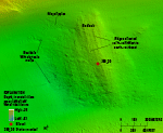
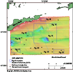
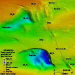
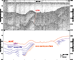
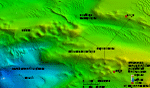
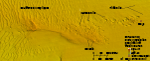
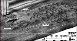
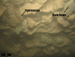
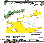
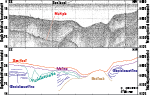
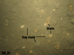
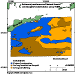
InterpretationWe interpret a number of sea-floor features in the study area from the bathymetric, sidescan-sonar, sediment, and photographic data. These include bedrock, drumlins, boulders, ridges of cobbles and gravel, large bathymetric depressions, obstacle marks, glaciolacustrine sediments, sand waves and megaripples, and trawl marks (fig. 28). BedrockThe rocky bathymetric high in the northwestern part of the study area with ridges oriented north-northwest to south-southeast is interpreted to be glacially striated bedrock (fig. 12). Although Needell and Lewis (1984) mapped this feature as a moraine, their interpretation was based on a single seismic profile that revealed only a hard surface reflection that forms acoustic basement (fig. 29). Because the bathymetric high has distinct linear features that parallel those of nearby glacially striated bedrock outcrops and the inferred flow of the Laurentide Ice Sheet, we interpret the bathymetric high to be exposed, glacially carved bedrock with a thin, discontinuous, overlying layer of sand, gravel, and scattered boulders. DrumlinsThe shape, size, and orientation of the bathymetric highs south of the eastern end of Fishers Island suggest that they are drumlins (fig. 14). Seismic lines over these features show unstratified, acoustically opaque sediment suggestive of glacial deposits exposed on the sea floor (fig. 15). Sediment and photographic data confirm that the bathymetric highs are covered with boulders, gravel, and sand. Although we interpret them to be drumlins, it is also possible that these features are exposures of bedrock that are draped with sand and gravel and covered with boulders, like the area to the west that we interpreted to be bedrock. BouldersBoulders are found along the southern shore of Fishers Island and in the southern part of the study area on several isolated bathymetric highs, in addition to being in the areas we interpret to be exposed bedrock and drumlins. Boulders that are visible in the bathymetry data are generally several meters wide. Boulders along the coast of Fishers Island form the submerged flanks of a section of the Harbor Hill-Roanoke Point-Charlestown-Buzzards Bay end moraine deposited around 20,400 to 22,400 years ago (Balco, 2011). Several rocky areas that form bathymetric highs are exposed glacial deposits, bedrock, and winnowed, basal-till-capped coastal plain strata (Needell and Lewis, 1984). Two rocky areas in the southeast corner of the study area have low relief and are east-west-elongated boulder fields (fig. 18). Although they are southeast of, and in line with, the drumlins, these rocky areas have lower profiles (around a meter in height) than the drumlins, irregular shapes, and trends normal to those of the drumlins. They have been interpreted as exposed coastal plain sediments capped by a thin layer of winnowed basal till by Needell and Lewis (1984). Other bouldery bathymetric highs in the southwestern part of the study area are found in irregularly shaped boulder fields among areas of sand waves. These areas are likely composed of winnowed glacial deposits found between the Ronkonkoma-Block Island-Nantucket and Harbor Hill-Roanoke Point-Charlestown-Buzzards Bay moraines, or they could be composed of coastal plain sediments capped by basal till like similar areas in the southeast part of the study area. CobblesThe northern and eastern flanks of the western bathymetric depression have a smooth appearance in the bathymetry and, according to sediment and photographic data, are covered with cobbles and gravel (fig. 16). The northwestern flank connects to a feature interpreted to be a moraine to the west of the study area (Poppe and others, 2006, 2007) and is likely an extension of it. The southern part of this feature may not be part of the moraine as it has an orientation dissimilar to that of the moraine, thus we interpret the southern part of the cobble and gravel pavement to be undifferentiated glacial deposits. Gravel appears to be forming barchanoid-shaped ridges with horns pointing toward the west. We would argue, however, that these ridges differ in mode of formation from barchanoid dunes, being simply piles of gravel excavated from the adjacent scour depression to the west. Large Bathymetric DepressionsEast-west-oriented channels in the study area and the bathymetric depressions within them are likely maintained by strong tidal currents (White and White, 2012) passing through The Race. The western bathymetric depression is the relatively shallow, eastern end of a large scour depression located along the eastern side of a moraine that lies perpendicularly across a channel east of The Race (Poppe and others, 2006, 2007). The presence of gravel and cobbles on the northern and eastern flanks of the depression indicates that turbulence associated with strong tidal currents likely forms eddies and scours the surrounding sea floor, leaving a coarse lag and forming gravel ridges (fig. 16). The two central bathymetric depressions are just to the west of the line of drumlins (fig. 14). The northern depression has boulders at the bottom and along the eastern slope, which has likely eroded into the western edge of a drumlin and underlying glacial deposits. The steep (19-degree) walls of the Deep Hole are composed of laminated reddish brown and gray semiconsolidated silty clay, which was observed as outcrops and rip-up clasts (station 298_36; fig. 23). Seismic lines (Needell and Lewis, 1984; Poppe and others, 2002) in the area show thick layers of laminated sediments, interpreted by Needell and Lewis (1984) to be glaciolacustrine sediments that underlie a thin layer of fluvial, estuarine, or marine deposits (fig. 30). These glaciolacustrine sediments are exposed along the northern and eastern walls of the Deep Hole where they have been eroded by strong currents. Rip-up clasts can also be seen in photographs of an area east of the bathymetric low (station 298_6; fig. 31), showing that the clasts are being removed from the depression and scattered on the surrounding sea floor. These depressions were likely formed when the glacial lake in present-day Block Island Sound was drained and fluvial channels were cut into underlying strata (Needell and Lewis, 1984). The positions of the bathymetric depressions, especially the northern one, may be related to the line of drumlins located just to the east. The drumlins likely formed a barrier to fluvial flow, which consequently changed direction and eroded the outside of the bends, scouring deeply into the underlying glaciolacustrine sediments where the depressions are located. Strong tidal currents funneling through channels in this area scour the sea floor around obstacles such as the drumlins and form eddies in the bathymetric depressions, which maintains and continues to erode the depressions, exposing the laminated glaciolacustrine sediments on the steep eastern wall of the Deep Hole and the flanks of a drumlin and underlying glacial deposits to the east of the northern depression. Mottled AreasMottled areas in the sidescan-sonar data represent hummocky areas of the sea floor with possible variations in sediment texture (fig. 20). The low-backscatter areas are slightly elevated according to the bathymetry data and are likely composed of outcropping sediments that are finer grained but more resistant than sediments in the high-backscatter areas. Net Sediment TransportNet sediment transport directions in the study area can be determined by asymmetry in obstacle marks and bedforms. Obstacle marks are visible in the bathymetric data around many boulders in the study area (figs. 12, 14, and 18). As currents pass around boulders and form eddies, areas of the sea floor around the obstructions are scoured and form obstacle marks. In the study area, many obstacle marks are asymmetrical, with longer marks on the western side of boulders indicating westward net sediment transport. The asymmetry of sand waves and megaripples in the study area, with westward-oriented slip faces, also indicates generally westward net sediment transport (fig. 13). Trawl MarksTrawl marks tend to be seen in sandy areas without sand waves, where featureless modern marine sediments cover the sea floor; however, they can also be seen along the edges of sand-wave fields where sand has not yet filled them (fig. 18). Sedimentary EnvironmentsThe three sedimentary environments in the study area are those characterized by the processes of erosion or nondeposition, coarse-grained bedload transport, and sorting and reworking (fig. 32). Environments of erosion or nondeposition are found where tidal currents are strongest in the east-west-oriented channels, where there is a prevalence of boulders and gravel on the sea floor, and in large scour depressions, such as Deep Hole. Coarse-grained bedload transport occurs where there are sand waves and megaripples, which is throughout much of the southern part of the study area and in parts of the northeast. Environments characterized by sorting and reworking are in eastern parts of the study area, where tidal current speeds are generally low, the sea floor is sandy, and there are no distinct sea-floor features, other than some areas of trawl marks, which are preserved in these relatively low-energy environments. |

![]() U.S. Department of the Interior |
U.S. Geological Survey
U.S. Department of the Interior |
U.S. Geological Survey
URL: http://pubsdata.usgs.gov/pubs/of/2014/1224/html/ofr2014-1224-interp.html
Page Contact Information: GS Pubs Web Contact
Page Last Modified: Wednesday, 07-Dec-2016 20:06:59 EST