 |
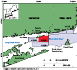
Figure 1. Map showing the location of National Oceanic and Atmospheric Administration (NOAA) survey H12298 (red-shaded polygon) offshore of Fishers Island, New York. Also shown are other NOAA surveys (gray-shaded polygons) that have been interpreted in this series in Rhode Island and Block Island Sounds, including H12299 (McMullen, Poppe, Danforth, and others, 2014); H12296 (McMullen, Poppe, Ackerman, and others, 2014); H12023 (McMullen and others, 2013); Block Island Sound survey, a combination of surveys H12009, H12010, H12011, H12015, H12033, H12137, and H12139 (Poppe and others, 2012); and H12250 (Poppe and others, 2007). |
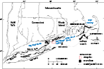 |
Figure 2. Map of end moraines (black-shaded polygons) and submerged ridges associated with the offshore extensions of these moraines (dashed lines) in southern New York and New England (modified from Gustavson and Boothroyd, 1987) along with the study area (red-outlined polygon). The Ronkonkoma-Block Island-Nantucket terminal moraine represents the maximum advance of the Laurentide Ice Sheet about 25,500 to 28,100 years ago, whereas the Harbor Hill-Roanoke Point-Charlestown-Buzzards Bay end moraine represents a retreated ice-sheet position from about 20,400 to 22,400 years ago (Balco, 2011). |
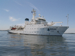 |
Figure 3. Photograph of the National Oceanic and Atmospheric Administration (NOAA) ship Thomas Jefferson, which collected bathymetric data in the study area. Photograph courtesy of NOAA. |
 |
Figure 4. Photograph of National Oceanic and Atmospheric Administration (NOAA) launch 3102, one of two survey launches used to collect bathymetric and sidescan-sonar data in the study area. Photograph courtesy of NOAA. |
 |
Figure 5. Photograph of the RESON SeaBat 7125 multibeam-echosounder transducer used to collect bathymetric data in the study area. Photograph courtesy of the National Oceanic and Atmospheric Administration. |
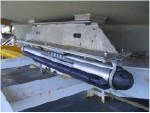 |
Figure 6. Photograph of the Klein 5000 sidescan-sonar system hull-mounted on a survey launch. Photograph courtesy of the National Oceanic and Atmospheric Administration. |
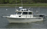 |
Figure 7. Photograph of the U.S. Geological Survey research vessel (RV) Rafael used to collect bottom photography and sediment samples in the study area. |
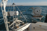 |
Figure 8. Photograph of the small Seabed Observation and Sampling System (SEABOSS), a modified Van Veen grab sampler with attached video and still cameras. The SEABOSS is deployed from the starboard side of the U.S. Geological Survey research vessel Rafael by using a winch, mounted on a davit (left), and a take-up reel for the video-signal and power cable (right). |
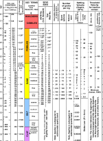 |
Figure 9. Chart showing the relations among phi sizes, millimeter diameters, size classifications (Wentworth, 1922), and American Society for Testing and Materials (ASTM) and Tyler sieve sizes. Chart also shows the corresponding intermediate diameters, grains per milligram, settling velocities, and threshold velocities for traction. Abbreviations in the image include cm/sec, centimeter per second; d, diameter; m, meter; mg, milligram; mm, millimeter; µm, micrometer; no., number; °C, degrees Celsius; and ", inch. Chart produced in the Woods Hole Coastal and Marine Science Center Sediment Lab. |
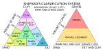 |
Figure 10. Sediment-classification scheme from Shepard (1954), as modified by Schlee (1973) and Poppe and others (2004). Special characters include %, percent; <, less than. |
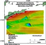 |
Figure 11. Hill-shaded multibeam bathymetry of National Oceanic and Atmospheric Administration survey H12298. Bathymetry is color-coded for depth, with warm colors (reds) representing shallow water and cool colors (blues) representing deep water. |
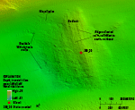 |
Figure 12. Detailed multibeam-bathymetric image of exposed bedrock on the sea floor of the study area. Bedrock has ridges oriented north-northwest to south-southeast that parallel nearby onshore and offshore glacially striated bedrock (Goldsmith, 1962; Schafer, 1965; and Poppe and others, 2007). Location of image is shown in figure 13. |
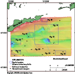 |
Figure 13. Map of the study area showing locations of the detailed multibeam figures (dark blue rectangles), seismic profiles (light blue lines), and interpreted directions of net sediment transport based on sand-wave and obstacle-mark asymmetry (black arrows). Fig., figure. |
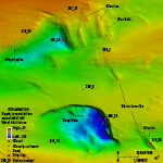 |
Figure 14. Detailed multibeam-bathymetric image of the two eastern bathymetric depressions in the study area and the drumlins to their east. The southern depression, Deep Hole, has a steep eastern and northern wall composed of silty clay (see figure 23). The northern depression has gravel and boulders at the bottom and along the eastern wall where it has likely eroded into the nearby glacial drift topped with features we interpret to be drumlins. Location of image is shown in figure 13. |
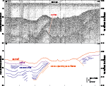 |
Figure 15. Seismic-reflection profile (Needell and Lewis, 1984; Poppe and others, 2002) and interpretation of a section of line a81_218, which crosses the study area to the east of the eastern bathymetric depressions and through glacial sediments. Unstratified glacial deposits underlie drumlins and are surrounded by laminated glaciolacustrine sediments with overlying modern marine deposits. Location of profile is shown in figure 13. |
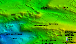 |
Figure 16. Detailed multibeam-bathymetric image of the western bathymetric depression and the ridges of cobbles along its eastern and northern sides. Sand waves and megaripples can also be seen in the image. Some of the cobble ridges have barchanoid shapes. The northern section of cobble ridges connects to a moraine located to the west of the study area and is thought to be an extension of it. Location of image is shown in figure 13. |
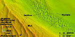 |
Figure 17. Detailed multibeam-bathymetric image of sand waves and megaripples in the southwestern part of the study area. Sand waves in this area generally have wavelengths of about 100 meters, whereas the megaripples have wavelengths that are tens of meters. Location of image is shown in figure 13. |
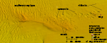 |
Figure 18. Detailed multibeam-bathymetric image of boulders, many with obstacle marks, sand waves and megaripples, and trawl marks, in the southeast part of the study area. Although this area was mapped by Needell and Lewis (1984) as exposed coastal plain sediments, the presence of numerous boulders indicates that the underlying deposits are covered by at least a thin layer of winnowed basal till. Sand waves and megaripples with steep, westward-facing slip faces and asymmetry of obstacle marks around boulders indicate westward net sediment transport. Trawl marks caused by dragging fishing gear appear as grooves on the sea floor in the eastern part of the image. Location of image is shown in figure 13. |
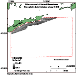 |
Figure 19. Image of sidescan-sonar data collected in the National Oceanic and Atmospheric Administration survey H12298 study area. Sidescan-sonar data were only collected within 1 to 2 kilometers of Fishers Island. Light tones indicate areas with higher backscatter and generally coarser grained sediments than those in areas of dark tones. |
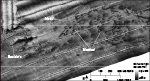 |
Figure 20. Detailed image of boulders and mottled areas in sidescan-sonar data. Boulders appear as high-backscatter (light tones) targets with low-backscatter (dark tones) shadows. Mottled areas are patches of high and low backscatter reflecting a hummocky sea floor and possible differences in sediment texture. In each line, the nadir, or area directly under the launch when data are collected, is also visible. Location of image is shown in figure 13. |
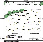 |
Figure 21. Map showing locations of sediment samples collected in the study area during cruise 2013-005-FA on the research vessel (RV) Rafael. Samples are color-coded according to grain size. |
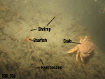 |
Figure 22. Photograph of a boulder at station 298_33. Hydrozoans cover a boulder, and shrimp, starfish, and a crab are present. Photograph location is shown in figure 25. |
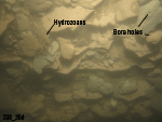 |
Figure 23. Photograph from station 298_36 showing an outcrop and rip-up clasts of silty clay that make up the steep eastern wall of Deep Hole, the largest and deepest bathymetric depression within the study area. The varved glaciolacustrine sediment, which has been exposed by erosion, is composed of alternating layers of gray and reddish brown sediments that cleave into clasts. The clasts have bio-eroded bore holes in them and hydrozoans are present. Photograph location is shown in figure 25. |
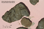 |
Figure 24. Photograph of semiconsolidated clasts of glaciolacustrine sediment obtained in the grab sample at station 298_36. Clasts have bio-eroded bore holes and are gray and reddish brown. |
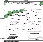 |
Figure 25. Map of the locations of bottom photographs taken in the study area during cruise 2013-005-FA on the research vessel (RV) Rafael. |
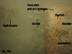 |
Figure 26. Photograph of a boulder at station 298_20. The boulder is covered with anemones, hydrozoans, barnacles, starfish, and tunicates and (or) sponges. Gravel and sand with scattered shell hash can be seen on the sea floor. Photograph location is shown in figure 25. |
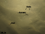 |
Figure 27. Photograph of a sandy sea floor at station 298_9. Sand is rippled, and burrows, scattered shell hash, and snails are present. Photograph location is shown in figure 25. |
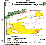 |
Figure 28. Interpretation of the sea floor in the National Oceanic and Atmospheric Administration survey H12298 study area. Features include bedrock, boulders, cobbles, drumlins, glaciolacustrine sediment, trawl marks, and sand waves and megaripples. Areas of the study area that are not outlined appear generally featureless in the multibeam bathymetry data and are interpreted to be modern marine sediments. Interpretations are based on multibeam-bathymetry, sidescan-sonar, sediment, and photographic data collected in the study area. |
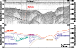 |
Figure 29. Seismic-reflection profile (Needell and Lewis, 1984; Poppe and others, 2002) and interpretation of a section of line a81_224, which crosses the west-central part of the study area. Stratified glaciolacustrine sediments are draped over acoustic basement interpreted to be bedrock. A fluvial unconformity can be seen cutting into the glaciolacustrine sediments southeast of the bedrock. Modern marine sediments overlie the glaciolacustrine and fluvial/estuarine sediments. Location of profile is shown in figure 13. |
 |
Figure 30. Seismic-reflection profile and interpretation of a section of line a81_225 (Needell and Lewis, 1984; Poppe and others, 2002), which crosses two of the eastern bathymetric depressions. These depressions are eroded into glaciolacustrine sediments, and the southern depression has formed between moraine and coastal plain sediments and filled with fluvial and estuarine sediments. A layer of fluvial and estuarine sediments overlies the glaciolacustrine sediments between the two depressions, and elsewhere modern marine sediments overlie the glaciolacustrine sediments. (Interpretations after Needell and Lewis, 1984). Location of profile is shown in figure 13. |
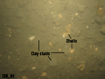 |
Figure 31. Photograph of clay clasts and scattered shells on the sea floor at station 298_6, located to the east of a bathymetric depression with walls composed of silty clay glaciolacustrine sediment. The clasts at station 298_6 are likely derived from the depression and carried downcurrent where they are deposited on the sea floor. Photograph location is shown in figure 25. |
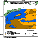 |
Figure 32. Map of sedimentary environments in the National Oceanic and Atmospheric Administration survey H12298 study area, interpreted from multibeam-bathymetric, sidescan-sonar, sediment samples, and bottom photography data. Sedimentary environments in the study area include those characterized by processes of erosion or nondepostion, coarse-grained bedload transport, and sorting and reworking. |

