Open-File Report 2014-1224
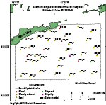
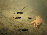
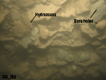
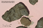
SedimentsSediment DistributionThe sea floor in the study area is mostly composed of sand with gravel and gravelly sediment on bathymetric highs (fig. 21). One station (298_33; fig. 22) in the bottom of the northern bathymetric depression is classified as gravel on the basis of photography because a sample could not be obtained. Sand waves and megaripples cover much of the southern, western, and northeastern parts of the study area; they tend to be coarser grained in the west, where the mean grain sizes are about 1 to 2 phi, than in the east, where mean grain sizes are about 3 phi. A station (298_7) on the side of an east-west channel, in moderately deep water near the eastern border, has a sea floor of silty sand. The steep eastern wall of the Deep Hole (station 298_36) is composed of layered semiconsolidated outcrops and rip-up clasts of gray and reddish brown silty clay sediments (figs. 23 and 24). Sediment DataThe sediment grain-size dataset provided in this report contains information on the collection, description, and texture of sediments at 36 stations in the study area. The sea floor was sampled at only 25 of the stations owing to either coarse-grained sediment or a rough sea state that prevented a sample from being obtained. Stations where samples could not be obtained were visually classified on the basis of video and still photography obtained at the station. These stations have no-data values (-9999) in the textural and statistical sections of the sediment dataset. The basic structure of the dataset is a matrix where rows represent individual samples and columns (fields) contain sample- and station-specific information. This matrix consists of 42 fields that are defined in the “Data Dictionary” below. Data DictionaryAn integral part of any database is the dictionary that explains the structure and content. It contains a list of the fields and definitions of parameters measured. This compilation defines abbreviations and lists field names, which makes the data easier to use. LABNO - Unique sample identifier assigned in the laboratory STATIONID - Sample name or number assigned in the field PROJECT - Project under which samples were taken or data were generated CRUISEID - Name or number of cruise on which the sample was collected or station was occupied PRINCIPAL - Name of the principal investigator LATITUDE - Latitude in decimal degrees (north latitudes are positive values) LONGITUDE - Longitude in decimal degrees (west longitudes are negative values) DEPTH_M - Depth of water overlying sediment at the time of sampling, measured by a hull-mounted fathometer, corrected for draft, but not corrected for tides, in meters T_DEPTH - Top depth of the sample below the sediment-water interface, in centimeters B_DEPTH - Bottom depth of the sample below the sediment-water interface, in centimeters DEVICE - Device used to collect the sample MONTH - Number of calendar month during which the sample was collected DAY - Calendar day on which the sample was collected YEAR - Calendar year during which the sample was collected WEIGHT - Dry weight of sample, in grams ZGRAVEL - Gravel content in percentage of dry weight of the sample (particles with nominal diameters greater than 2 mm; -1 phi and larger) ZSAND - Sand content in percentage of dry weight of the sample (particles with nominal diameters less than 2 mm but greater than or equal to 0.0625 mm; 0 through 4 phi, inclusive) ZSILT - Silt content in percentage of dry weight of the sample (particles with nominal diameters less than 0.0625 mm but greater than or equal to 0.004 mm; 5 through 8 phi, inclusive) ZCLAY - Clay content in percentage of dry weight of the sample (particles with nominal diameters less than 0.004 mm; 9 phi and smaller) SEDCLASS - Sediment description based on a rigorous definition (Shepard, 1954; Schlee, 1973; Poppe and others, 2004)
MEDIAN - Middle point in the grain-size distribution, in phi units MEAN - Average value in the grain-size distribution, in phi units STDDEV - Standard deviation (root mean square of the deviations) of the grain-size distribution, in phi units (that is, sorting) SKEWNESS - Deviation from symmetrical form of the grain-size distribution KURTOSIS - Degree of curvature near the mode of the grain-size distribution PHI_11 - Weight percentage of the sample in the 11-phi fraction (nominal diameter of particles greater than or equal to 0.0005 mm but less than 0.001 mm); fine clay PHI_10 - Weight percentage of the sample in the 10-phi fraction (nominal diameter of particles greater than or equal to 0.001 mm but less than 0.002 mm); medium clay PHI_9 - Weight percentage of the sample in the 9-phi fraction (nominal diameter of particles greater than or equal to 0.002 mm but less than 0.004 mm); coarse clay PHI_8 - Weight percentage of the sample in the 8-phi fraction (nominal diameter of particles greater than or equal to 0.004 mm but less than 0.008 mm); very fine silt PHI_7 - Weight percentage of the sample in the 7-phi fraction (nominal diameter of particles greater than or equal to 0.008 mm but less than 0.016 mm); fine silt PHI_6 - Weight percentage of the sample in the 6-phi fraction (nominal diameter of particles greater than or equal to 0.016 mm but less than 0.031 mm); medium silt PHI_5 - Weight percentage of the sample in the 5-phi fraction (nominal diameter of particles greater than or equal to 0.031 mm but less than 0.0625 mm); coarse silt PHI_4 - Weight percentage of the sample in the 4-phi fraction (nominal diameter of particles greater than or equal to 0.0625 mm but less than 0.125 mm); very fine sand PHI_3 - Weight percentage of the sample in the 3-phi fraction (nominal diameter of particles greater than or equal to 0.125 mm but less than 0.25 mm); fine sand PHI_2 - Weight percentage of the sample in the 2-phi fraction (nominal diameter of particles greater than or equal to 0.25 mm but less than 0.5 mm); medium sand PHI_1 - Weight percentage of the sample in the 1-phi fraction (nominal diameter of particles greater than or equal to 0.5 mm but less than 1 mm); coarse sand PHI_0 - Weight percentage of the sample in the 0-phi fraction (nominal diameter of particles greater than or equal to 1 mm but less than 2 mm); very coarse sand PHIM1 - Weight percentage of the sample in the -1-phi fraction (nominal diameter of particles greater than or equal to 2 mm but less than 4 mm); very fine pebbles (granules) PHIM2 - Weight percentage of the sample in the -2-phi fraction (nominal diameter of particles greater than or equal to 4 mm but less than 8 mm); fine pebbles PHIM3 - Weight percentage of the sample in the -3-phi fraction (nominal diameter of particles greater than or equal to 8 mm but less than 16 mm); medium pebbles PHIM4 - Weight percentage of the sample in the -4-phi fraction (nominal diameter of particles greater than or equal to 16 mm but less than 32 mm); coarse pebbles PHIM5 - Weight percentage of the sample in the -5-phi fraction (nominal diameter of particles greater than or equal to 32 mm); very coarse pebbles to boulders
|

![]() U.S. Department of the Interior |
U.S. Geological Survey
U.S. Department of the Interior |
U.S. Geological Survey
URL: http://pubsdata.usgs.gov/pubs/of/2014/1224/html/ofr2014-1224-seds.html
Page Contact Information: GS Pubs Web Contact
Page Last Modified: Wednesday, 07-Dec-2016 20:07:02 EST