
|
List of Figures
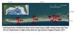 |
Figure 1. Locations of sites on Dauphin Island, Alabama, used to monitor water levels, atmospheric pressure, and temperatures from July 22 through November 20, 2013. Red dots on map indicate locations of sites. Inset base from the National Atlas of the United States, 2009. Aerial photo base from the U.S. Department of Agriculture, National Agricultural Imagery Program, 2011. |
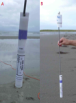 |
Figure 2. Photographs of RBR DR1060 pressure logger used on Dauphin Island, Alabama, in 2013. A, Close-up of RBR DR1060 pressure logger. B, RBR DR1060 pressure logger connected to well cap by threaded stainless-steel rod. The pressure senor is inserted into well casing and cap is screwed onto top of well (fig. 5E). |
 |
Figure 3. Photograph of the RBR Virtuoso D|wave sensor used on Dauphin Island, Alabama, in 2013. |
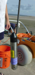 |
Figure 4. Photograph of one of the Onset Hobo U20 pressure loggers and threaded stainless-steel rod used on Dauphin Island, Alabama, in 2013. |
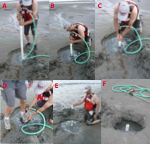 |
Figure 5. Photograph of one of the Onset Hobo U20 pressure loggers and threaded stainless-steel rod used on Dauphin Island, Alabama, in 2013. A–C, well casing being jetted into the sand; D, well casing at the end of jetting; E, pressure sensor inserted into the casing; and F, completed installation with pressure sensor inserted and cap screwed into the well casing. |
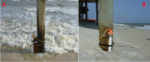 |
Figure 6. Photographs of well casings strapped to pilings of porches on Dauphin Island, Alabama, in 2013. A, The well casing at site 968 after being buried and strapped to a piling on the porch of a private residence. B, The well casing at site 971 after being buried and strapped to a porch piling. |
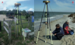 |
Figure 7. Photographs of Global Position System (GPS) base station and rover on Dauphin Island, Alabama, in 2013. A, Base station near the entrance of Fort Gaines on the eastern side of Dauphin Island. B, U.S. Geological Survey Scientists surveying the well at site 972 with a GPS rover before recovering the sensor from the well. Erosion of the beach on the Mississippi Sound side of the island beach between deployment and recovery left the top of the well at site 972 exposed. |
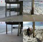 |
Figure 8. Photographs illustrating burial of well at site 968. A, View of porch piling and the well at site 968 immediately after deployment; the well is at the base of the piling the farthest to the left in the picture. B, The well at site 968 strapped to piling shortly after deployment. C, View of porch piling with well completely buried just before recovering sensor from well. D, U.S. Geological Survey scientist digging out the well at site 968. |
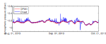 |
Figure 9. Atmospheric pressure time series from National Oceanic and Atmospheric Administration station DPIA1 and USGS measurements from an Onset Hobo U20 pressure sensor at site 965 on Dauphin Island, Alabama, in 2013. Although the study covered from July 22 through November 20, 2013, this graph only shows August 1 through October 1, 2013, to highlight the difference between the two sensors. dbar, decibars. |
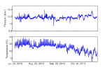 |
Figure 10. Atmospheric pressure and temperature time series from an Onset Hobo U20 atmospheric pressure sensor mounted on a residential porch railing at site 965 on Dauphin Island, Alabama, in 2013. dbar, decibars; °C, degrees Celsius. |
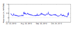 |
Figure 11. Water-level time series from an RBR DR1060 pressure logger mounted in a buried well at site 966 on Dauphin Island, Alabama, in 2013. m, meters; NAVD88, North American Vertical Datum of 1988. |
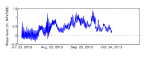 |
Figure 12. Water-level time series from an RBR Virtuoso D|wave pressure logger mounted in a buried well at site 968 on Dauphin Island, Alabama, in 2013. m, meters; NAVD88, North American Vertical Datum of 1988. |
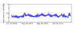 |
Figure 13. Water-level time series from an Onset Hobo U20 pressure logger mounted in a buried well at site 969 on Dauphin Island, Alabama, in 2013. m, meters; NAVD88, North American Vertical Datum of 1988. |
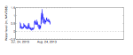 |
Figure 14. Water-level time series from an RBR DR1060 pressure logger mounted in a buried well at site 970 on Dauphin Island, Alabama, in 2013. m, meters; NAVD88, North American Vertical Datum of 1988. |
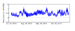 |
Figure 15. Water-level time series from an RBR DR1060 pressure logger mounted in a buried well at site 971 on Dauphin Island, Alabama, in 2013. m, meters; NAVD88, North American Vertical Datum of 1988. |
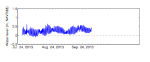 |
Figure 16. Water-level time series from an RBR DR1060 pressure logger mounted in a buried well at site 972 on Dauphin Island, Alabama, in 2013. m, meters; NAVD88, North American Vertical Datum of 1988. |
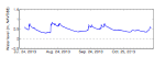 |
Figure 17. Water-level time series from an Onset Hobo U20 pressure logger mounted in a buried well at site 973 on Dauphin Island, Alabama, in 2013. m, meters; NAVD88, North American Vertical Datum of 1988. |
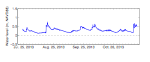 |
Figure 18. Water-level time series from an Onset Hobo U20 pressure logger mounted in a buried well at site 974 on Dauphin Island, Alabama, in 2013. m, meters; NAVD88, North American Vertical Datum of 1988. |
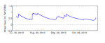 |
Figure 19. Water-level time series from an Onset Hobo U20 pressure logger mounted in a buried well at site 975 on Dauphin Island, Alabama, in 2013. m, meters; NAVD88, North American Vertical Datum of 1988. |
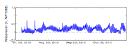 |
Figure 20. Water-level time series from an Onset Hobo U20 pressure logger mounted in a buried well at site 976 on Dauphin Island, Alabama, in 2013. m, meters; NAVD88, North American Vertical Datum of 1988. |
|

