Open-File Report 2014-1245
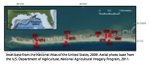
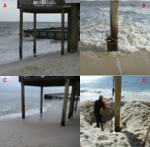
Site DescriptionDauphin IslandDauphin Island is a populated, low-lying barrier island in the northern Gulf of Mexico (fig. 1). It is bordered by Mobile Bay to the east, Mississippi Sound to the north and west, and the Gulf of Mexico to the south. Dauphin Island is frequently exposed to the force of hurricanes from the Gulf of Mexico, the most recent of which was Hurricane Katrina in 2005, which breached the western portion of the island. Site 965Site 965 was at a residence off St. Stephens Street. An Onset Hobo U20–001–04 atmospheric pressure sensor was mounted in a PVC tube that was hose clamped to the second floor porch railing of the residence. Site 966Site 966 was in a small channel in an empty lot on the Mississippi Sound side of the island about 200 m to the west of St. Stephens Street. An RBR DR1060 pressure sensor was mounted in a well buried in the beach. Site 967Site 967 was on the beach on the Mississippi Sound side of the island and to the north of the public parking lot at the western end of the island. An RBR DR1060 pressure sensor was mounted in a well buried in the beach. The sensor at site 967 could not be located for recovery, so the data were lost. Site 968Site 968 was on the Gulf of Mexico side of the island at a residence on Bienville Boulevard. An RBR Virtuoso D|wave was mounted in a well buried in the beach and strapped to a piling on the southeastern side of the residence. The piling the instrument was strapped to was in the swash zone of the beach at high tide when the instrument was deployed. About 0.6 to 0.8 m of sediment had accumulated at this site between deployment and recovery, completely burying the well (fig. 8) and making recovery difficult. Site 969Site 969 was on the Mississippi Sound side of the island in a small channel near Sam Houston Road. An Onset Hobo U20–001–01 pressure sensor was mounted in a well buried in the beach. Site 970Site 970 was on the Gulf of Mexico side of the island at a residence on Bienville Boulevard. An RBR DR1060 was mounted in a well buried in the beach and strapped to a piling on the southeastern side of the residence. Site 971Site 971 was on the Gulf of Mexico side of the island at a residence on Seneca Street. An RBR DR1060 was mounted in a well buried in the beach and strapped to a piling on the southwestern side of the residence. Site 972Site 972 was along the beach on the Mississippi Sound side of the island. An RBR DR1060 pressure sensor was mounted in a well buried in the beach. Site 973Site 973 was directly between sites 971 and 972 in the middle of the island. An Onset Hobo U20–001–04 pressure sensor was mounted in a well buried in the sand. Site 974Site 974 was in the middle of the island between sites 967 and 968 in a lot behind a home on Bienville Boulevard. An Onset Hobo U20–001–01 pressure sensor was mounted in a well buried in the sand. Site 975Site 975 was in the middle of the island in a channel in an empty lot just off St. Stephens Street and between sites 966 and 970. An Onset Hobo U20–001–04 pressure sensor was mounted in a well buried in the sand. Site 976Site 976 was along the beach on the Mississippi Sound side of the island very near the inlet of the canal next to St. Stephens Street. An Onset Hobo U20–001–01 pressure sensor was mounted in a well buried in the beach. Sometime before recovery, a large pile of sand (about 1 m high by 2 m in diameter) was placed over the sensor location and had to be removed so the instruments could be recovered. |
|

![]() U.S. Department of the Interior |
U.S. Geological Survey
U.S. Department of the Interior |
U.S. Geological Survey
URL: http://pubsdata.usgs.gov/pubs/of/2014/1245/ofr2014-1245-site-description.html
Page Contact Information: GS Pubs Web Contact
Page Last Modified: Wednesday, 07-Dec-2016 20:05:50 EST