Open-File Report 2015-1238
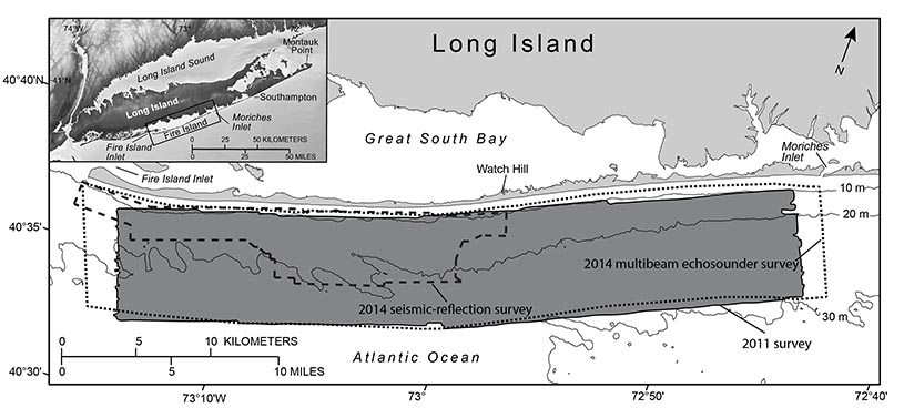
IntroductionHurricane Sandy, the largest storm on historical record in the Atlantic basin (Blake and others, 2013), made landfall in southern Long Island, New York, and surrounding areas in October 2012 (Hapke and others, 2013). Before this strong storm event, starting in 1996, the U.S. Geological Survey (USGS) had long been involved in research in the region to evaluate the influence of the regional geologic framework on coastal evolution and formulate a conceptual model of sediment flux in the coastal ocean (Schwab and others, 2000, 2013, 2014). In May 2011, the USGS conducted a high-resolution marine geophysical survey of the lower shoreface and inner continental shelf offshore of Fire Island (fig. 1), a barrier island on the southern side of Long Island, using interferometric sonar and seismic-reflection techniques (Schwab, Denny, and Baldwin, 2014). Ultimately, the 2011 survey served to document conditions on the inner continental shelf at Fire Island approximately 6 months before the passage of Hurricane Sandy. The USGS conducted additional surveys in 2014, initially in January and February, to document conditions after the storm in cooperation with the U.S. Army Corps of Engineers (USACE), which served to resurvey the 2011 study area using a high-resolution multibeam echosounder. In October 2014, another survey focused on a series of shoreface-attached sand ridges offshore of western Fire Island, using a high-resolution seismic-reflection profiler (fig. 1). The objectives of the 2014 surveys were to determine the impact of Hurricane Sandy on the inner continental shelf morphology and modern sediment distribution and to broaden the baseline geospatial framework for sediment transport and coastal change model development (U.S. Geological Survey, undated). This report documents the changes in seabed morphology and modern sediment thickness measured between the mapping investigations from the 2011 (Schwab, Baldwin, and Denny, 2014) and 2014 surveys. Hurricane Sandy produced sustained winds of 25.1 meters per second (m/s) and wave heights as sizeable as 9.7 meters (m), measurements about 25 and 50 percent higher, respectively, than most other large storms during the previous 17 years (Goff and others, 2015; National Oceanic and Atmospheric Administration, undated a). The single exception was Hurricane Irene (August 2011), which impacted the area shortly after the 2011 survey (Schwab, Baldwin, and Denny, 2014) and produced sustained winds of 19.2 m/s and significant wave heights of 7.9 m (Goff and others, 2015; National Oceanic and Atmospheric Administration, undated b). Although Hurricane Sandy was a larger storm event and likely had the greatest impact to the sea floor, Hurricane Irene is also likely to have contributed to the changes to the sea floor revealed by the analyses presented in this report. |

![]() U.S. Department of the Interior |
U.S. Geological Survey
U.S. Department of the Interior |
U.S. Geological Survey
URL: http://pubsdata.usgs.gov/pubs/of/2015/1238/ofr2015-1238-introduction.html
Page Contact Information: GS Pubs Web Contact
Page Last Modified: Wednesday, 07-Dec-2016 21:49:35 EST