Skip past header information
USGS - science for a changing world

Open-File Report 2015–1238
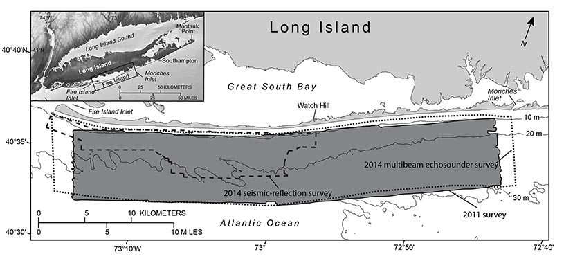
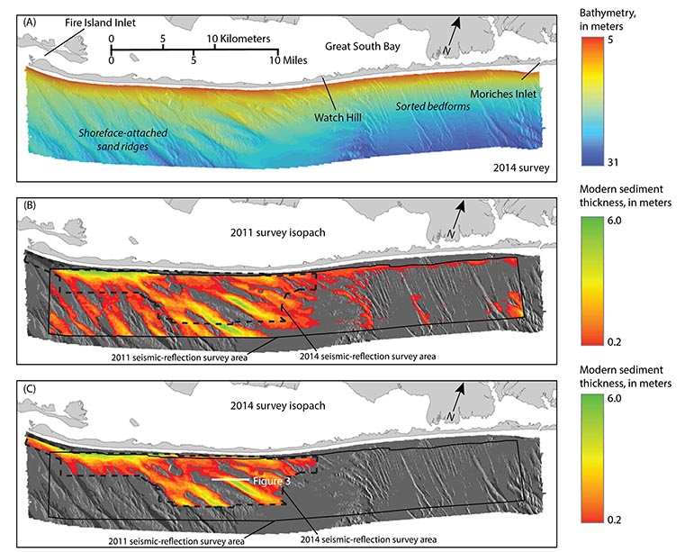
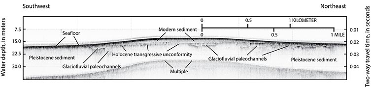

Assessing the Impact of Hurricanes Irene and Sandy on the Morphology and Modern Sediment Thickness on the Inner Continental Shelf Offshore of Fire Island, New York


Skip past contents information
Map showing the 2011 and 2014 surveys offshore of Fire Island, New York

Figure 1. Map showing the 2011 (shaded in dark gray) and 2014 (multibeam echosounder survey outlined by dotted line and seismic-reflection survey outlined by dashed line) surveys offshore of Fire Island, New York. Inset map shows location of study area (outlined in black). Bathymetric contours are in meters (m) below the North American Vertical Datum of 1988 (NAVD 88). Figure modified from Schwab, Baldwin, and Denny (2014).

Map showing the interpolated bathymetric surface generated from multibeam echosounder data collected offshore of Fire Island, New York, in January 2014.

Figure 2. A, Map showing the interpolated bathymetric surface generated from multibeam echosounder data collected offshore of Fire Island, New York, in January 2014 (Denny and others, 2015). Bathymetry is in meters (m) below the North American Vertical Datum of 1988 (NAVD 88). B and C, Maps illustrating the thickness of modern sediment derived from seismic-reflection data collected in 2011 (Schwab, Baldwin, and Denny, 2014) and 2014, respectively. These isopachs are overlain on the sun-illuminated bathymetric surface derived from the bathymetric surface shown in A. West of Watch Hill, the modern sand deposits are organized into a series of shoreface-attached sand ridges oriented obliquely to the shoreline. The Pleistocene glacial outwash units are exposed in the troughs between the ridges and across other portions of the inner continental shelf where the modern deposits are absent. The presence of sorted bedforms on the inner continental shelf east of Watch Hill is indicative of this active erosion of the glacial outwash units (Schwab, Baldwin, Denny, and others 2014).

Chirp seismic-reflection profile illustrating the stratigraphic features and geometries discussed in this report

Figure 3. High-resolution chirp seismic-reflection profile illustrating the stratigraphic features and geometries discussed in this report. Location of the profile is shown in figure 2C. Approximate water depth in meters was converted from two-way travel time assuming a seismic velocity of 1,500 meters per second.

Geologic Setting

The southern shore of Long Island west of Southampton, N.Y., consists of reworked glacial outwash associated with the Wisconsinan Laurentide glacial advance (Stone and Borns, 1986) and includes shallow back-barrier bays, marshes, and low-relief, sandy barrier islands (Leatherman and Allen, 1985). Located within this barrier-island system is Fire Island, a 0.5-kilometer (km)-wide, 50-km-long barrier island that is bound by two tidal inlets, Moriches Inlet to the east and Fire Island Inlet to the west (fig. 1), that are managed as navigation channels.

Complete reviews of the major inner continental shelf sedimentary sequences offshore of Fire Island are provided by Schwab, Denny, and Baldwin (2014) and Schwab, Baldwin, Denny, and others (2014). The shallow geologic framework south of Fire Island primarily composes Pleistocene glaciofluvial outwash deposits that are exposed over much of the inner continental shelf (figs. 2 and 3). The upper surface of the outwash is incised by paleochannels (fig. 3) that are filled with a transgressive sequence composing reworked outwash and, in places, caps of lower Holocene muddy estuarine sediment. Where modern sandy deposits unconformably overlie portions of the Pleistocene and lower Holocene units, they clearly define a regional unconformity (termed the Holocene transgressive unconformity) that is interpreted to be a product of Holocene marine transgression (fig.3). The modern sandy sediments (fig. 2) are derived through erosion of the older sedimentary deposits exposed at the sea floor as the transgression continues (Schwab, Baldwin, Denny, and others 2014).

Accessibility FOIA Privacy Policies and Notices

Take Pride in America logo USA.gov logo U.S. Department of the Interior | U.S. Geological Survey
URL: http://pubsdata.usgs.gov/pubs/of/2015/1238/ofr2015-1238-geologic_setting.html
Page Contact Information: GS Pubs Web Contact
Page Last Modified: Wednesday, 07-Dec-2016 21:49:35 EST