Skip past header information
USGS - science for a changing world

Open-File Report 2016–1119


Shallow Geology, Sea-Floor Texture, and Physiographic Zones of Vineyard and Western Nantucket Sounds, Massachusetts


Skip past contents information/ Title Page / List of Figures / Conversion Factors / Abbreviations / Abstract / Introduction / Methods / Results / Discussion / Summary / Acknowledgments / References Cited / Appendix 1 — Geospatial Data / Citation Page /


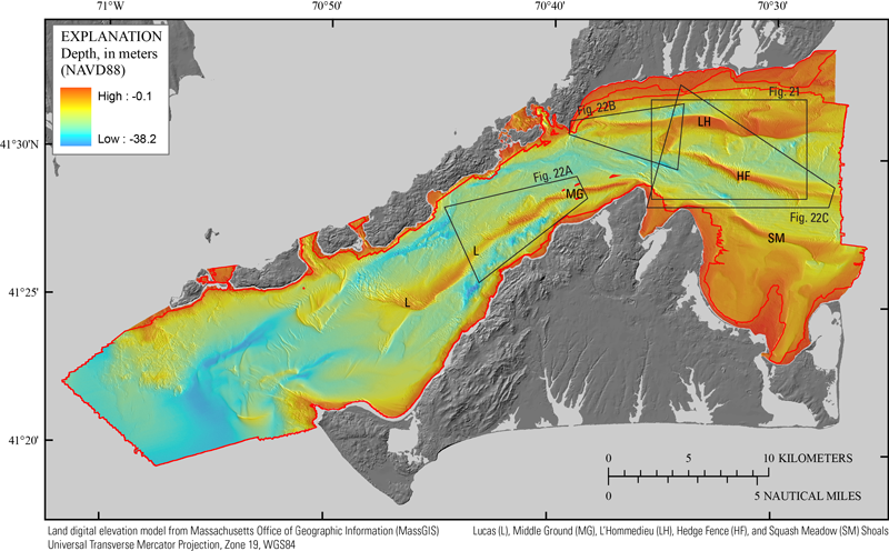
A digital elevation model produced from swath and single-beam bathymetric data gridded at a 10-meter-per-pixel horizontal resolution.


Figure 3. A digital elevation model (DEM) produced from swath (interferometric, multibeam, and lidar; collected within the red polygon) and single-beam (collected outside the red polygon) bathymetric data gridded at a 10-meter-per-pixel horizontal resolution (table 1). Black polygons indicate areas of figures 21 and 22. Depth is referenced to the North American Vertical Datum of 1988. The locations of Lucas (L), Middle Ground (MG), L'Hommedieu (LH), Hedge Fence (HF), and Squash Meadow (SM) Shoals are also indicated.

Accessibility FOIA Privacy Policies and Notices

Take Pride in America logo USA.gov logo U.S. Department of the Interior | U.S. Geological Survey
URL: http://pubsdata.usgs.gov/pubs/of/2016/1119/ofr20161119_figure3.html
Page Contact Information: GS Pubs Web Contact
Page Last Modified: Wednesday, 11-Oct-2017 17:56:32 EDT