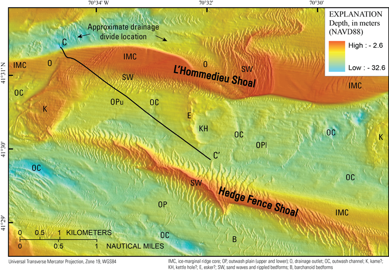
Figure 21. Detailed bathymetric map of Nantucket Sound in the vicinity of L’Hommedieu and Hedge Fence Shoals. The presence of large sand waves (SW) with fields of smaller rippled bedforms superimposed upon them clearly identify the extents of the sandy shoal deposits. Where the sandy sediments thin, deglacial morphologies, including the ice-marginal drift ridge cores (IMC) underlying the shoals, drainage outlets cut through the ice-marginal cores (O), outwash plains (OP; OPu, upper; Opl, lower), outwash channels (OC), ice-contact deposits possibly in the form of kame (K) and esker (E), and kettle holes (KH), are clearly identifiable across the adjacent sea floor. While the deglacial morphologies are well preserved between these shoals, they are significantly subdued within the main channel of the sound to the south of Hedge Fence Shoal, presumably due to differential erosion of the sea floor by wave and tidal currents during marine transgression. Barchanoid bedforms (B) are indicative of sediment transport in the presence of strong tidal currents within the main channel of the sound. Black arrows identify the inferred directions of drainage entering Nantucket Sound from the Mashpee Pitted Plain (fig. 1) as flow was divided upon intersecting L’Hommedieu Shoal. Black line indicates location of seismic reflection profile C - C’ (fig. 12). See figure 14 for map location.
|
