Open-File Report 2017-1165
| Field Data Collection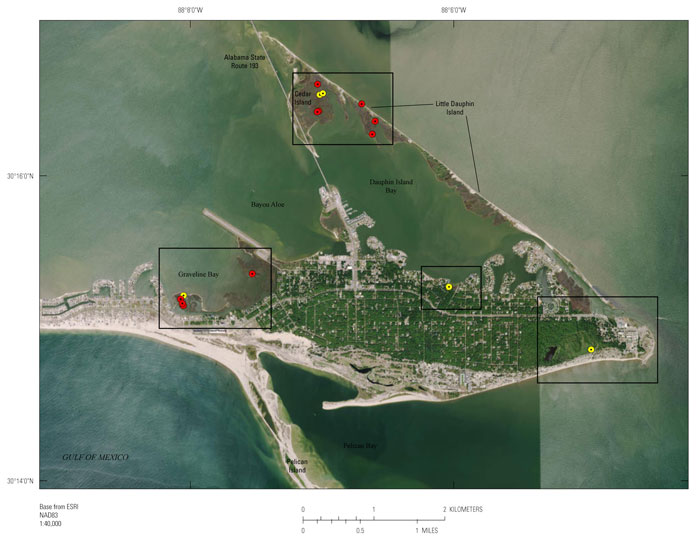 Figure 2. Map showing the location of all marsh push cores collected on Dauphin Island, Alabama, during the August 2015 (red) and April 2013 (yellow) sampling trips and relevant geographic features. Click on the box outlines to zoom in on the sampling areas. All sites are labeled with the core number and corresponding transect number, if applicable.
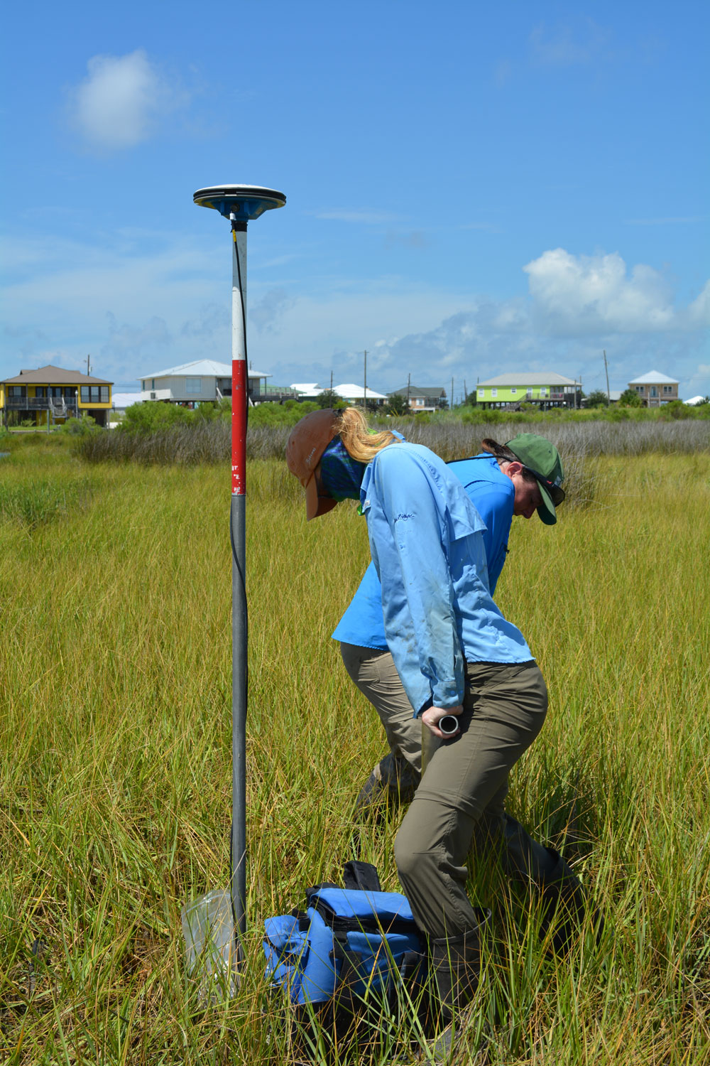
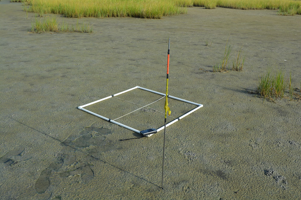
 In August 2015, eleven 11.4-centimeter (cm)-diameter marsh push cores were collected using acrylic tubes during a 9-day sediment sampling trip on and around Dauphin Island, Alabama (USGS Field Activity Number [FAN] 2015-322-FA, project identification [ID] 15BIM09) (figs. 2 and 3). Of the 11 cores, 4 were collected from Cedar Island, the northernmost portion of Little Dauphin Island [referred to as transect 1: DA30M, DA31M(A), DA31M(B), and DA32M]; 3 were collected from Little Dauphin Island (transect 2: DA33M, DA34M, and DA35M); and 4 were collected from the marshes bordering Graveline Bay on the north side of Dauphin Island (DA40M, transect 3: DA42M, DA45M, and DA46M) (fig. 2). These 11 cores complement the 5 push cores collected from Dauphin Island in April 2013 as part of the Barrier Island Evolution Research (BIER) Project, which included looking at barrier island migration (BIM; FAN 13BIM01). Of those 5 cores, one is located on the southern face of Dauphin Island in an Audubon Bird Sanctuary freshwater swamp (DA01M); one is located on a small patch of marsh on the northern face bordering Dauphin Island Bay (DA05M); one is from the marsh bordering Graveline Bay on the north side of Dauphin Island (DA13M, part of transect 3); and two are from Cedar Island (DA04M and DA27M, part of transect 1) (fig. 2). All cores were kept on ice until they were transported back to the St. Petersburg Coastal and Marine Science Center (SPCMSC) where they were refrigerated both prior to and after being sectioned. The location (latitude and longitude) of all sites was recorded on both a handheld Global Positioning System (GPS) receiver and a Differential GPS (DGPS) receiver, which were also used to record site elevation. The DGPS coordinates were constrained by post-processed differential corrections using a base station-to-rover setup. Each site was occupied for a minimum of 30 minutes. For more specific information regarding the locations and setup of the base stations, rover configurations, and post-processing, refer to USGS Data Series 1046 (Ellis and others, 2017). Shear vane measurements were recorded with an AMS inspection vane within a couple of meters of each marsh push core site. At each site, four measurements were collected—one in the center of each quadrant of a 1-square-meter (m2) grid—in order to account for variation in vegetation, sediment, and users (fig. 4). The raw shear vane recordings are available in the data release (Ellis and others, 2018).
|

![]() U.S. Department of the Interior |
U.S. Geological Survey
U.S. Department of the Interior |
U.S. Geological Survey
URL: http://pubsdata.usgs.gov/pubs/of/2017/1165/ofr2017-1165_collection.html
Page Contact Information: GS Pubs Web Contact
Page Last Modified: Tuesday, 20-Mar-2018 14:19:41 EDT